
After being inspired and captivated by the awesome scenery of the South Big Sur Coast and Silver Peak Wilderness on the South Coast Adventure, I was eager to return for more exploration in the region, this time for a very aesthetic loop that comes in around 25-26 miles. Aside from repeat visits to the incredible Mount Mars and Buckeye Trail, this loop added a lot of new terrain for me, including upper Villa Creek, Lion Peak, the Three Peaks area and Dutra Flats. If a point-to-point is too cumbersome to arrange (this is, after all, the most remote section of the Big Sur coast), than this loop is the perfect way to hit hit the highlights and see a lot of the terrain in the region. I’ll definitely be returning for further exploration in the South Big Sur region. Strava GPS route here.


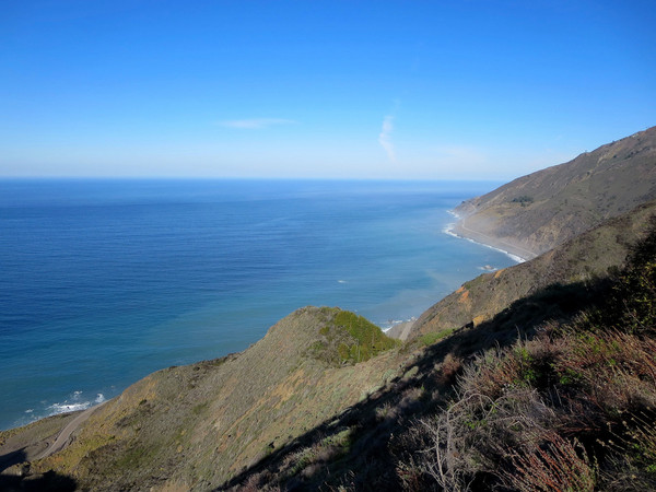
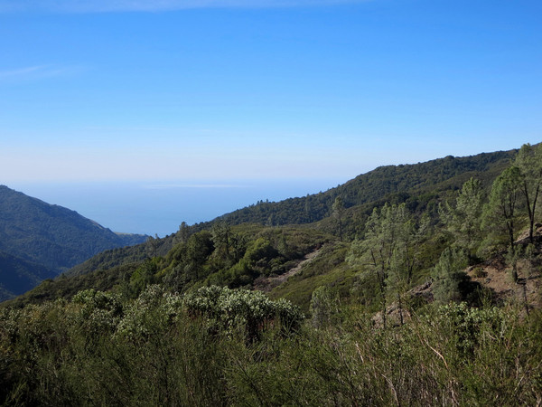
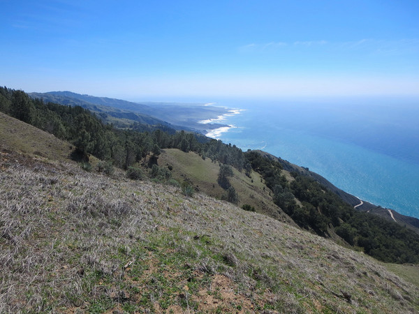
The loop starts with switchbacks on the Cruikshank Trail on a south facing chaparral slope that can be hot even in the morning. However, the trail soon rounds a corner and enters the lovely Villa Creek Canyon and begins one of the best sections of single track in all of Big Sur. From top to bottom, the Cruikshank Trail packs an incredible amount of biodiversity in its six miles, including redwoods, various pine species, Douglas fir, Santa Lucia Firs, Sargent’s cypress, various oak species, and madrone. Note that there is also plenty of poison oak alongside the trail in its upper portion. The trail also has excellent views to the ocean and a rugged section of Villa Creek canyon with reddish rocks characteristic of this region. About 5.75 miles from the start, the Cruikshank Trail crosses a saddle with a young Sargent’s cypress forest where a spur path heads west to Silver Peak while the main trail heads down to the beautiful Lion Den camp. This camp has to be one of the best in Big Sur, complete with a spring, ample shade under the pines, and a commanding view overlooking Salmon Creek canyon, Silver Peak and the Pacific Ocean. Beyond Lion Den Camp, the Cruickshank heads uphill a short distance to meet the South Coast Ridge Road. A short ways south along the road is an optional side trip to Lion Peak. While the road comes close to the summit, a small bushwhack is still necessary to reach the top. Most of the unpleasantness can be avoided by leaving the road at a small saddle near the peak and entering a dense thicket. While not entirely devoid of bushwhacking, travel is reasonable and the distance is short so it only takes 10-15 minutes. It is well worth the troubles with an excellent 360 degree panorama from the exposed reddish summit block. The vista includes Cone Peak and Junipero Serra Peak to the north, Silver Peak and Lion Den camp, Three Peaks, the Salmon Creek canyon, and interior views to Burro Mountain.
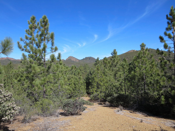
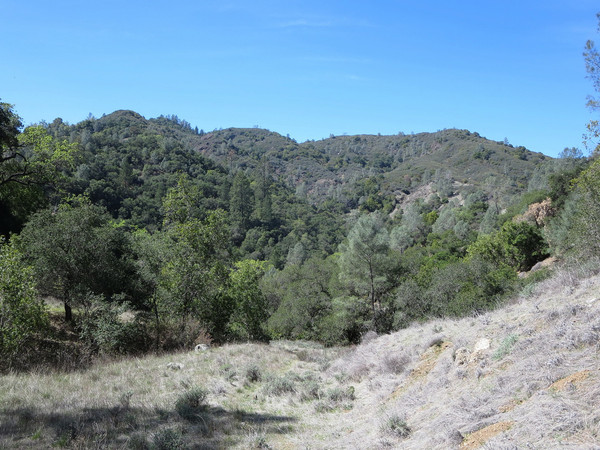
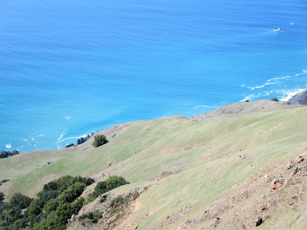
After Lion Peak, more quick running along South Coast Ridge Road leads to the Three Peaks Trail, which is an old firebreak along the ridge with vegetation that has filled in to make it a single track. Overall, the trail is in fairly good condition and largely brush-free save for a couple spots. It’s an efficient way to go from the South Coast Ridge Road to the Dutra Flats area. The land is mainly covered in chaparral and exposed to sunlight, but there are some pretty stands of coulter pine and gray pine along the way with nice views back to Lion Peak and terrain to the south. Most of the way to Dutra Flats, the Three Peaks trail crosses a prominent ridge and on the other side are awesome views of the meadows in Dutra Flat and County Line Ridge. Dutra Flat is a peaceful meadow area with heritage oaks and pines. A camp is located at the flats under cypress trees and it appears this area is used for cattle grazing. From Dutra Flat, the Murray Mine Track which leads down to Dutra Creek and then steeply up to County Line Ridge. This is a pretty section with straightforward navigation and nice views of Mount Mars and the surrounding region. 

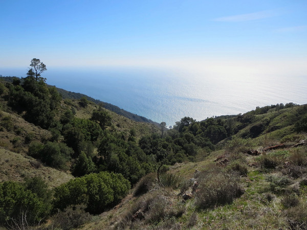
From County Line ridge, take the Mount Mars use path up and over a couple false summits to the summit of Mount Mars, with nice views of Salmon Creek canyon, Lion Peak and Silver Peak. Descend through the vegetation tunnel on Mount Mars and emerge onto the grassy ridge with an outstanding view down the ridge to the Pacific Ocean and Salmon cone. From Kozy Kove meadows at the bottom of the very steep ridge, take the use path to the Salmon Creek Trail which quickly descends to the trailhead along Hwy 1. The Buckeye trail is a short distance away and climbs steeply at first (can be hot) but becomes more reasonable as it enters oak woodland beyond the junction with the Soda Springs Trail. There is typically water in Soda Spring Creek about halfway to Buckeye Camp. The Buckeye Trail features marvelous coastal vistas back to Mount Mars and Piedras Blancas, and is one of the best coastal trails in Big Sur. Buckeye Camp is always a treat with its cool fresh spring water and shady heritage oaks in the meadow. Beyond Buckeye Camp, the Buckeye Trail makes one final climb to Buckeye Vista before entering a pine forest that switchbacks down to upper Cruikshank camp. The final downhill portion along the lower Cruikshank Trail bring you back to the Cruikshank trailhead. 


2 CommentsAdd yours