
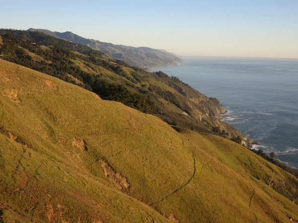
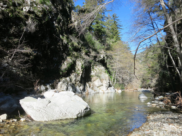
The Mocho Loop is another Big Sur Classic combining spectacular coastal views, a magical walk through a lush river canyon, and a rarely seen waterfall on the main stem of the South Fork Big Sur River. I started the loop with an always-inspiring hike up Boronda Ridge and then ran down the Coast Ridge Road with more marvelous coastal vistas all the way to the top of the Terrace Creek trail. Terrace Creek descends into an old growth redwood grove with a cascading stream along the way. At the bottom of Terrace Creek I took the Pine Ridge Trail to Sykes Hot Springs. The Pine Ridge trail is in awesome condition; the best I have seen it personally. The Pine Ridge Trail is also very runnable with excellent views of the Big Sur River canyon. When the Pine Ridge Trail crosses the Big Sur River, instead of going downstream to the springs I went upstream to the confluence of the North and South Forks of the Big Sur River. This mile-long stretch to the confluence is very pretty with cliffs walls on both sides of the river. At the confluence I went right onto the South Fork Big Sur River. For about 3 miles from the confluence I made my way up the South Fork fairly efficiently as a combination of flood channels, sand bars and rock hopping meant I only had to be in the stream part of the time. Higher flow on the river would make this a more arduous trek as I as continuously crossing the stream. GPS route here.

 After a major tributary, the canyon walls along the South Fork Big Sur River narrow into a gorge and I could sense a waterfall was coming. Indeed around a cliffy corner the lower section of Mocho Falls appeared. Since the falls is on the main stem of the river, the volume is impressive and the pool beneath the falls is big and deep. Perhaps most impressive is the amphitheater of smooth rock surrounding the falls and pool. The vertical walls around the falls meant I had to backtrack to find a route above the falls to continue upstream. A weakness in the cliffs allows one to ascend a very steep slope above the gorge and then traverse steep, sometimes loose slopes above the waterfall gorge. Mocho Falls has two distinct steps, but what was most fascinating about the falls was a twisty chasm of elegantly sculpted and polished rock separating the two steps. The depth of the chasm was such that it was impossible to see both steps of the falls at the same time cleanly (at least without a wetsuit and ropes). Nonetheless, what is visible is an amazing sight and it was a treat to experience this rarely seen falls. I can only imagine what Mocho Falls would look and sound like after a heavy rain when the water is squeezed through the chasm. In fact, after such rains the roaring sound of the falls is so great that it can be easily heard from the Devils Staircase climb up the Big Sur Trail.

 Above Mocho Falls the lovely scenery continues with slick rock pools with fern and moss-covered cliffs a constant. At the junction with Mocho Creek I ate lunch under a lovely canopy of Santa Lucia Firs, incense cedars and redwoods – a rare occasion to have all three of these amazing tree species living side-by-side – yet another wonder of Big Sur! After lunch I went up Mocho Creek a short distance to see Mocho Creek Falls, which is a pretty falls in a lush setting – well worth the visit. Instead of continuing up Mocho Creek to intersect the Big Sur Trail I decided to backtrack to the South Fork Big Sur River to take the river all the way to Rainbow Camp. It was so beautiful I didn’t want it to end and I also wanted to do the Devils Staircase climb a little later in the day when it would be shaded. This turned out to be a good decision with more beautiful pools and cascades along the river lined with Santa Lucia Firs. At Rainbow Camp I turned onto the Big Sur Trail for the climb up to Cold Springs and Coast Ridge, known as the Devils Staircase due to the relentless switchbacks and substantial elevation gain. In all, it took me about 1.5 hours to go from Rainbow Camp to Cold Springs up the Devils Staircase, hardly “impassable” as some have commented (although a big pack would certainly slow things down). Bright green flagging marks the trickiest spots in the riparian zones. There are blowdowns along the climb and the brush is thick at times, but progress is reasonable. Back on the Coast Ridge Road I knew I was setting myself up for another awesome descent down Boronda Ridge in evening light. Going down this special ridge is always a fantastic way to end an adventure run, particularly a classic like the Mocho Loop! GPS route here.


2 CommentsAdd yours