Another phenomenal day on the mountain I call the King of Big Sur! Cone Peak rises 5,155 ft above the Pacific Ocean in less than three miles as the crow flies, making it one of the steepest gradients from ocean to summit in the contiguous United States. It’s nearly a vertical mile above the glimmering ocean with a commanding view of the Big Sur Coast. My first visit to this grand mountain was in 2010 via the “standard” all-trail route from Kirk Creek to Vicente Flat and the Cone Peak Trail. I repeated this route in 2011. It was only in 2013 when I did the Stone Ridge Direct route that the possibilities for off-trail exploration on Cone Peak really clicked for me. Since then I’ve visited Cone Peak frequently exploring the various trails and routes on this amazing mountain. GPS route here.

 On this day, I joined Joey Cassidy for the next step of my personal discovery of Cone Peak by tackling a series of rock scramble routes. In the process we ascended all three of Cone Peak’s prominent ridges: the Southeast Ridge, the North Ridge and the ridge linking Cone Peak to Twin Peak. We also included an ascent of the short but sweet West Rib, arguably the finish of the Cone-Twin Ridge, which makes up for its short length with relatively solid rock (for the Santa Lucia Mountains) and an outrageous setting of stunning views in the background. A special thanks goes to Joey Cassidy for showing me the northeast face and the west rib, routes he had previously scoped out and climbed. It’s always a pleasure to join Joey on adventures, especially since he’s an extremely talented photographer. His photos of me on these scrambles were so awesome I’ve included a few in this post so double thanks goes to Joey for contributing (credit indicated below or above his photos). We started with an ascent of Stone Ridge Direct, as beautiful as ever, rising from the redwood-filled canyons of Limkiln to the exposed grassy slopes and finally the Ventana alpine zone with Santa Lucia Firs, Coulter Pines and Sugar Pines. Once we crossed over to Cone Peak via the Twin-Cone Ridge we took the Cone Peak trail down to a point where we could access the Southeast Ridge, a prominent ridge separating the Limekiln drainage from the San Antonio River drainage.
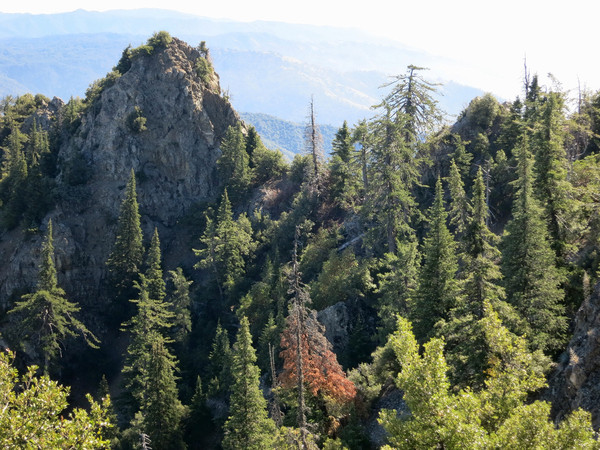
 Southeast Ridge: The Southeast Ridge is extremely scenic with amazing views of Stone Ridge and also the rugged cirque on the northeast side of Cone Peak giving a nice angle on the face that we would climb later that day. The Southeast Ridge included some sections of class 3 scrambles. The more difficult sections could by bypassed by dropping off the north side of the ridge and traversing underneath, but we chose to stick to the crest of the ridge and enjoy as much rock scrambling as we could. The most difficult part of the Southeast ridge is a loose downclimb from the prominent knob along the ridge into a deep notch. Once in the notch the route is finished with a straightforward scramble up to the Cone Peak Trail.

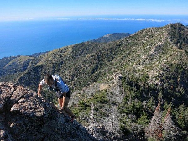
West Rib: The west rib of Cone Peak (pictured above) is a short pitch of remarkably solid rock for the Santa Lucia Mountains. Most rock in the Santa Lucias is very crumbly so when a pitch is fairly solid it’s automatically a gem! However, what makes the West Rib so sweet is its amazing position above Twin Peak, Stone Ridge and the South Fork Devils Canyon. A stunning panorama surrounds you as you ascend the rib to the summit. Instead of traversing around the mountain and taking the switchbacks to the top, simply scramble up the boulder field to the base of the rib. There are easier and looser routes to the summit from this point, but the prominent west rib is the line to climb with its relatively solid rock and mixture of enjoyable 3rd/4th class moves. Credit goes to Joey Cassidy for introducing me to this sweet little finish to summit Cone and it’s going to be hard for me to resist climbing the west rib every time in the future versus taking the trail.  Northeast Face: The Northeast Face is the most dramatic, committing and steepest scramble offered by Cone Peak’s topography. The route starts from a talus field along the North Coast Ridge Trail where you look up into a cliffy cirque with the lofty summit of Cone Peak perched 1,200 ft above. After ascending loose talus, the route enters a gully filled with Santa Lucia Firs. Depending on where you enter the gully dictates how much of the gully you ascend but you ultimately look to exit the gully onto rock on climbers right where you officially start the climb up the northeast face. The rock becomes more vertical and the scrambling begins in earnest. It should be noted that staying in the gully will take you away from the Northeast Face and toward the deep notch on the Southeast Ridge – not the route I am describing. Once you’ve exited the gully and are on the Northeast Face there are numerous possibilities and micro-route finding challenges to ascend the class 3 face interspersed with class 4 climbing. Some lines will be more difficult than others, but the inhibiting factor in tackling the more vertical, exposed rock on the face is the inherent poor quality of the rock. This results in sometimes using vegetation as holds or foot steps. That being said, the rock is solid enough where you need it to be on the 4th class sections that it’s a very fun scramble.The crux moves are near the top where the holds become thin for a few moves but after surmounting this final cliff you emerge onto easier terrain near the top of the north ridge. As with the other scramble routes described, the setting is amazing with a view of the 5th class cliffs along the north ridge, and a vista above a pristine grove of old growth Santa Lucia Firs leading down to the San Antonio River drainage.
  Photos above and below by Joey Cassidy of me ascending the NE Face.
 North Ridge: We descended the North Ridge to reach the North Coast Ridge Trail which we took to the base of the Northeast Face route. The lower part of the north ridge is easy open terrain with a use path in sections. The upper part of the north ridge is more rugged with bits of scrambling in spots and a couple places where it’s most efficient to come off the ridge slightly to the west side to avoid loose rock formations and gendarmes on the ridge crest proper. This upper part of the north ridge has phenomenal views with lots of steep relief on both sides of the serrated rocky ridge, especially on the east side where cliffs plunge several hundred feet, including the cliffs of the northeast face route described above. Old growth Santa Lucia Firs and Sugar Pines are at home in this environment clinging to the cliffy slopes and thereby avoiding the periodic wildfires that sweep through these mountains. The scenery makes for some very enjoyable scambling on the north ridge, a classic route of Big Sur.
  In the photo below Joey enjoys the amazing views from the Southeast Ridge to Stone Ridge, the Middle Fork Limekiln Creek and Hare Canyon.
  Photo below by Joey Cassidy of me ascending the West Rib
 After the scramble routes we cruised down the Cone Peak Trail to Trail Spring and then ran the Gamboa Trail underneath the forest of Santa Lucia Firs and Sugar Pines in the headwaters of the South Fork Devils Canyon to Ojito Saddle, where we took the Stone Ridge Trail back to the lower part of Stone Ridge and down to Limekiln Canyon. The more time I spend exploring Cone Peak, the more I love the mountain!


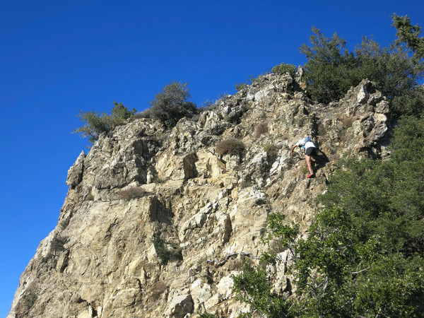


 Photo above and below by Joey Cassidy of me ascending the SE Ridge.
 Photo above and below by Joey Cassidy of the SE Ridge


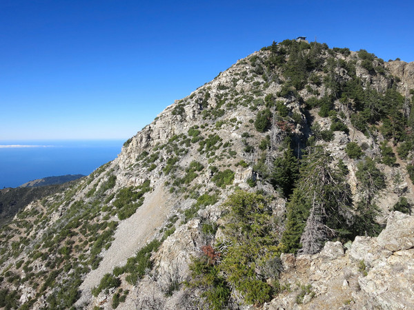


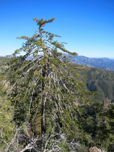


 Photo above by Joey Cassidy of me ascending the short but sweet West Rib.