
I visited Red Mountain and Hell for Sure Lake around the same time of year in 2012 and had an awesome time so I was looking forward to returning. This time I would ascend Mount Henry at the northern end of the Le Conte Divide with a striking vantage into Piute Canyon and the rugged section of the Sierra Crest in the John Muir Wilderness. As I wrote in 2012, the Le Conte Divide is an often overlooked area west of the Sierra Crest that features spectacular scenery and numerous opportunities for off-trail exploration making this region particularly suitable to adventure running. The divide forms the boundary between the John Muir Wilderness to the west and Kings Canyon National Park to the east. Geographically, to the east is the impressive Goddard Canyon and to the west is a series of spectacular granitic basins with dozens of pristine alpine lakes including Red Mountain Basin, Bench Valley and Blackcap Basin. The peaks on the divide are quite rugged, especially on their north and east sides, which belies the fact that these summits are only around 12,000 feet in elevation and higher neighbors to the east are well over 13,000 feet. Once again, elevation is not everything. The Le Conte Divide also one of the more remote sections of the range and therefore solitude can easily be achieved. The region is guarded by a long approach most often reached from Courtright Reservoir with a minimum of 15 miles on trail just to reach the basins. The long approach is ideal for adventure running as they are fairly moderate (runnable) and are within the pleasant montane forest zone for a large portion. Since the LeConte Divide is so remote, only a handful of peaks have names and the remainder are simply identified by their altitude. The basins to the west of the divide are quintessential Sierra scenery with dozens of gorgeous alpine lakes, tarns and meadows. GPS route here.


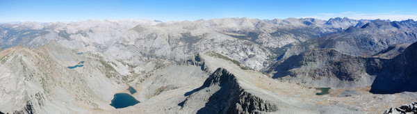
 On this trip I covered familiar ground for the first 12 miles to the junction with the Hell for Sure Pass Trail. Instead of turning right I continued straight covering new trail to Indian Lakes. From Indian Lakes I headed off cross country through forest that transitioned to grassy benches and granite slopes that led to the West Ridge of Mount Henry. Staying on the crest of the ridge yields some class 3 scrambling. An easier route that I took on the descent is to utilize a chute to access the West Ridge further up. Either way, all of the scrambling is on the lower part of the West Ridge as the upper part transitions to easy talus hopping. Mount Henry’s position at the northern end of the Le Conte Divide provides a stellar view of surrounding mountains, especially looking west into Piute Canyon and the range of peaks from Seven Gables to Bear Creek Spire to Mount Darwin. I would put htis view up among the classics, with incredible relief from canyon to peak and lots of intricate layers in the terrain. Moreover, remote Lake 10,223 provides makes for a beautiful subject in the foreground. I spent a lot of time photographing and enjoying the marvelous vantage.
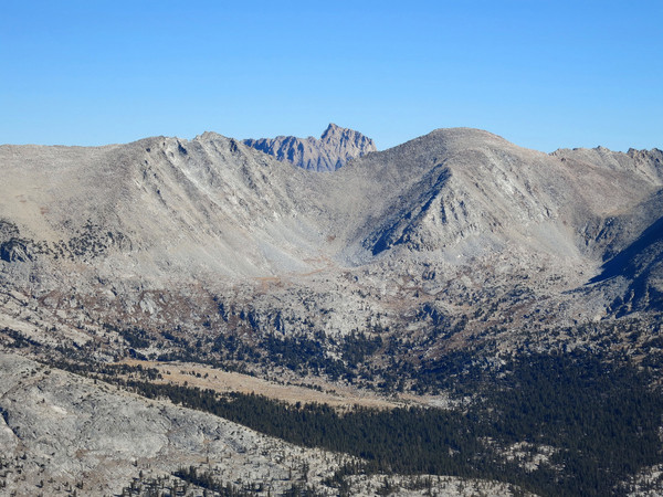
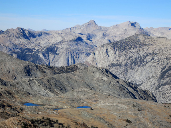
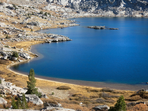
 On the descent I veered off the west ridge at its low point via a loose chute and then easy grass terrain down to aptly-named Turf Lakes with an expansive chunk of tundra between the lakes. From Turf Lakes, I embarked on an easy cross country traverse to Davis Lake and up Red Mountain. On Red Mountain I took the north ridge which had some fun solid scrambling instead of the loose west slopes which looked like a real slog. Red Mountain had the same great views I remembered from 2012, especially looking up Goddard Canyon to Mount Goddard and the Hell for Sure Lake Basin. A use path exists from Red Mountain down to Hell for Sure Pass and from there it was all trail back to Courtright Reservoir. In the future I hope to revisit the Le Conte Divdie for explorations of Bench Valley and Blackcap Basin. I would also like to revisit Red Mountain basin for further exploration including an ascent of Mount Hutton and stops at Devils Punchbowl, Little Shot Lake and Big Shot Lake. GPS route here.


Reds Peak same as red mountain?? curious. I did the 55mi Clark Range loop that took me over Reds peak a few weeks ago. beautiful area. best run ide had it a while. im gonna do it again in summer. i went from yosemite valley, to merced lake, washburn lake, reds peak, ottoway lake n around n along illiouette creek to JMT next to nevada falls n down. 17hours, but i stopped to look at alot of neat stuff 🙂