
The Santa Lucia Three Peaks is classic route that includes the summits of three major peaks in the Ventana Wilderness – Cone Peak, Twin Peak and Junipero Serra Peak. Along the way there are great views of both the Big Sur Coast and the interior Ventana Wilderness. While mostly utilizing trails, the route does feature three prominent cross-country ridges, the North Ridge of Cone Peak, the traverse between Cone Peak and Twin Peak, and the West Ridge of Twin Peak. These prominent off-trail ridges are probably the highlight of the route and make it an adventure. With the exception of redwoods, the route contains the entire array of Ventana vegetation, including perhaps the best Santa Lucia fir forest in existence, the most extensive stand of old growth Sugar Pines in the Santa Lucia Mountains, and rare grove of incense cedars in the Arroyo Seco river canyon. It’s a big route coming in over 32 miles with nearly 10,000 feet of elevation gain and the off-trail portions are fairly arduous and slow compared to the trails. Strava route here.


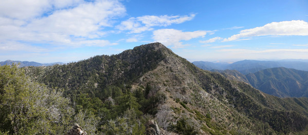
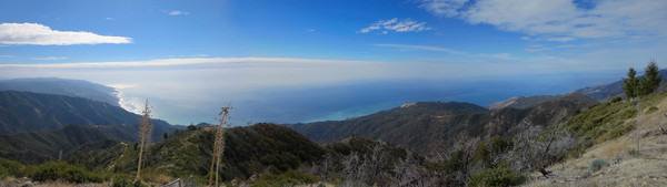
The route starts at Santa Lucia Memorial Park Campground after a drive through Fort Hunter Liggett (note: Del Venturi Road is closed after heavy rain). From Memorial Park, the Arroyo Seco Trail provides quick access to the North Coast Ridge Trail on a great single track. This upper section of the Arroyo Seco canyon is surprisingly lush and enchanting with madrone, oak, Santa Lucia Firs and a rare grove of Incense Cedars. Climbing out of the canyon, the vegetation turns more chaparral with a young forest of knobcone pine. On the north coast ridge, the trail climbs to Tin Can Camp with a great view looking back to Junipero Serra Peak and an awesome stretch through Sugar Pine and Coulter Pine forest. At the junction with the Gamboa Trail, veer left to continue on the North Coast Ridge Trail. Cross a rocky slope and then begin descending on the east side of Cone Peak before finding an easy gap to gain the crest of the north ridge of Cone Peak. The first part of the north ridge is easy open terrain with a use path in sections. The second part of the north ridge becomes more rugged with bits of scrambling in spots and a couple places where you must come off the ridge to the west side to avoid loose rock formations on the ridge crest proper. This second part of the north ridge has phenomenal views and an airy feeling with lots of relief on both sides of the serrated rocky ridge, especially on the east side where cliffs plunge several hundred feet. Old growth Santa Lucia Firs and Sugar Pines are at home in this environment clinging to the cliffy slopes and thereby avoiding the periodic wildfires that sweep through these mountains. The scrambling is very enjoyable on the north ridge, but it doesn’t last long before the familiar fire lookout atop 5,155 ft Cone Peak comes into view. Cone Peak is the King of the Big Sur Coast and third highest point in the Santa Lucia Mountains. It features the most dramatic relief from the ocean in the contiguous United States as only 3 miles separate its summit from the sands. After enjoying the marvelous views from Cone Peak, descend the Cone Summit Trail for a short distance and take the ridge connecting Cone Peak to Twin Peak. This cross country route features a couple scrambling moves but is largely a use path along the ridge. 

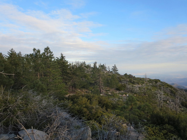
After summiting Twin Peak, continue down the West Ridge of Twin. At first, it is best to stay on the north side of the ridge in old growth Sugar Pine forest with an open understory. Some large downfalls slow travel but ultimately you reach the grassy slopes of the lower part of the ridge. The only paths on this ridge are made by game and their feet are much narrow than humans. The result is steep sidehilling than can become tiring but the views more than compensate. Eventually the grassy ridge terminates at the Stone Ridge Trail-Gamboa Trail junction at Ojito Pass. From Ojito Pass take the Gamboa Trail as it traverses through the headwaters of the South Fork Devils Canyon passing through arguably the most complete Santa Lucia forest in existence. A reliable spring is located at Trail Spings (can be a seep in late summer and fall). Continue along the Gamboa Trail past Trail Springs and climb to the junction with the North Coast Ridge Trail. From this junction retrace steps back to Santa Lucia Memorial Park Campground.


From Memorial Park, head south down the road a short distance and find the Santa Lucia Trail/Junipero Serra Peak Trailhead. For the first couple miles, the Santa Lucia Trail is very runnable as it undulates through grassland and oak woodland. However, the final four miles to the summit of Junipero Serra Peak become steep rising over 3,500 feet over that distance. This climb is a real challenge after the preceding climbs of Cone Peak and Twin Peak. It is not advisable on a warm day, especially in the afternoon since most of the climb is exposed south-facing chaparral. The vegetation changes in the last mile to the summit when the trail rounds a corner onto the north side of the peak where there is a pleasant forest of Sugar Pine and Coulter Pine. The broad summit of Junipero Serra Peak (aka Pimkolam by the Native Americans) is the highest point in the Santa Lucia Mountains at 5,862 feet. The summit has a nice vista looking west to Cone Peak, the Silver Peak Wilderness region, and also north to Ventana Double Cone. If Cone Peak is the King of Big Sur and Ventana Double Cone is the Queen of the Ventana, Junipero Serra is the grandfather of the Santa Lucias (Pico Blanco is the prince of Big Sur and Silver Peak is the princess of the South Coast). There is a summit a register on the east side of the ridge located on a cement foundation. The old dilapidated fire lookout on the west side of the ridge has virtually nothing left but its steel frame. There are also some old artifacts on the ridge, including an old cot frame. Enjoy the descent, which is virtually all downhill to the finish at Memorial Park; you will have earned it! Strava route here.


3 CommentsAdd yours