
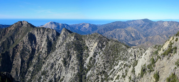
If Cone Peak is the King of the Big Sur Coast, Ventana Double Cone is the Queen of the Ventana Wilderness. Rising 4,853 ft above sea level, no other peak in the Ventana Wilderness possesses such a rugged face as Ventana Double Cone’s west and south aspects. Aptly named, the mountain features twin summits of nearly identical height, but it’s the southern summit that contains an astounding 360 degree view of the surrounding wilderness and Big Sur coastline. The peak serves as the divide for three major drainages in the northern Ventana Wilderess: the Little Sur River, the Big Sur River and the Carmel River. On a clear day, one can look north to Monterey Bay, Santa Cruz, the Santa Cruz Mountains and the Diablo Range. To the south lies the wild and scenic Big Sur River drainage, the Coast Ridge, Junipero Serra Peak and Cone Peak. To the east is Pine Valley, Chews Ridge, Ventana Cone, Pine Ridge, and South Ventana Cone. Immediately below is the immensely rugged and wild cirque that forms the headwaters of Ventana Creek. Across this impressive cirque and close at hand is La Ventana (aka the Window) and Kandlbinder Peak with Pico Blanco’s unmistakable white apron rising directly above La Ventana notch. Strava route here.


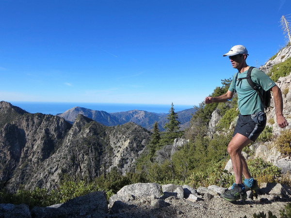
Adding to the allure of Ventana Double Cone is its remote position. The mountain is viewable from the trailhead at Bottcher’s Gap, but it requires nearly 15 miles on trail each direction (nearly 30 miles total) to reach. Moreover, there is quite a bit of undulating up and down en route which means lots of elevation gain can be expected in both directions (nearly 9,000 feet in all). Finally, the trail (particularly after Little Pines) can become brushy with sharp and scratchy chaparral so it’s advisable to cover the legs as much as possible for a more pleasant experience. While it’s a long way to Ventana Double Cone, the route is immensely scenic the entire distance. Largely following the ridge crest that forms the rim of the Little Sur River drainage, the scenery is spectacular and the forested sections are very pleasant. The first miles are in a madrone and oak forest up Skinner Ridge and then up to Devils Peak, which provides the first panoramic views from the route. From Devils Peak to Pat Springs, there are plenty of gorgeous grassy meadows with spectacular vistas to Pico Blanco, Ventana Double Cone and Kandlbinder Peak. Approaching Pat Springs, the vegetation transitions to ponderosa pine with a magnificent stand of old growth trees near the springs that survived the 2008 Basin Complex Fire. Pat Springs features cool, pure spring waters and it’s a must stop for any traveler continuing beyond to Ventana Double Cone. While there may be water in the springs beyond, none are as easy to access and as reliable as Pat Springs.

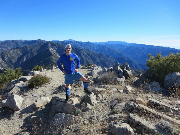
Beyond Pat Springs, the trail ascends through ponderosa pine forest to Little Pines and then gradually descends around the west side of Uncle Sam Mountain to Puerto Suello Pass. At this point the trail becomes more brushy with the worst brush located in the miles immediately south of Puerto Suello. Eventually the trail emerges from the brush on the final ridge leading to Ventana Double Cone. As one nears the summit, Coulter pines and Santa Lucia Firs grow strong next to the trail with increasingly broader views into the valleys and canyons below. The culmination of the journey is an amazing summit panorama where one feels like they’re on top of the world, or at least the Ventana! A fire lookout once stood at the summit, but has long been dismantled (I recommend similarly dismantling the ugly lookout atop Cone Peak which only serves to get in the way of the views). From Ventana Double Cone, it’s hard to not spend a lot of time soaking in the spectacular summit views, staring down into the rugged cirque of Ventana Creek, and admiring the tenacity of the Santa Lucia Firs clinging to the steep and rocky mountainsides. The following photos and route map are from a trip Ventana Double Cone on a clear day in late December, but we have since returned to the region to complete an off-trail traverse from Kandlbinder to La Ventana to Ventana Double Cone, which formed a large loop including the Jackson Creek route and the Ventana Double Cone Trail described above. We have called this route the “La Ventana Loop.” Stay tuned to this blog for details and many more photos from the La Ventana Loop and other Big Sur adventures! Strava route here.


For a 360 annotated panorama from the summit of Ventana Double Cone click here or the image below: 


Spectacular….. look forward to the Ventana/Kandlebinder loop session – that one sounds like borderline madness……great photos and the gps provides great data.
any poison oak in the brushy sections?
Sweet Trip. Good luck on that loop !
The La Ventana Loop was completed! /2014/02/24/la-ventana-loop-kandlbinder-la-ventana-ventana-double-cone/