
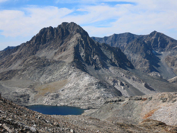
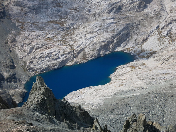
The Ionian Basin is one of the more remote and striking regions in the High Sierra. The feature names within the basin – Charybids, Three Sirens and Scylla – take on a Greek Mythology theme making it all the more intriguing. While the John Muir Trail crosses Muir Pass just to the northwest, few seem to venture into this trail-less region characterized by lots of talus and desolate lakes. A glance at the USGS Mount Goddard Quadrangle, within which the Ionian Basin is located, shows a map with essentially no green manifesting a region virtually devoid of vegetation. While I usually prefer some alpine vegetation, this stark landscape is unique and beautiful. The Ionian Basin is framed by the Goddard Divide to the north, the White Divide to the west and the Black Divide to the east. To the south is the rugged and wild Middle Fork of the Kings River. The basin is drained by a pair of deep canyons, Enchanted Gorge and Goddard Creek, separated by aptly-named Ragged Spur. These canyons are among the most remote and least visited spots in the Sierra. Mount Goddard presides over the basin and dominates the region from all angles. Numerous lakes occupy the Ionian basin, some of which are quite large, but only Chasm Lake has been assigned a name. The remainder of the dozen plus lakes are marked only be elevation. Last year I visited the west end of Ionian Basin on the way down from Mount Goddard to Lake 10,232. On this trip I traveled through the eastern portion and climbed Black Giant and Mount Charybdis. Both peaks featured tremendous views of the surrounding region. On Black Giant, I was particularly impressed with the sweeping view of Le Conte Canyon from Helen Lake to the Palisades. On Charbydis, my favorite view was down to Chasm Lake and the numerous lakes of the Ionian Basin. Charybdis is also a beautiful peak in itself including a fine scramble up its northeast ridge. I look forward to further exploration in Ionian Basin including visiting the shores of Chasm Lake and getting a close-up view of the The Three Sirens across Enchanted Gorge from Charybdis. GPS route here. 
Annotated view of Le Conte Canyon from Black Giant (click for large version): 
 The route starts with a run through Sabrina Basin, including one of my favorite views in the High Sierra at Sailor Lake with aptly-named Picture Peak towering above. Continue off trail beyond Sailor Lake to Moonlight Lake and then up easy terrain to Echo Lake, situated in a bowl beneath the Clyde Spires, Mount Wallace and Mount Powell. Travel becomes more arduous along a traverse above Echo Lake and the final glacial moraine slopes up to Echo Col. The south of side of Echo Col includes a spectacular view of Lake 11,428 with Black Giant’s rugged east face dominating the background. Traverse the west shore of Lake 11,428 and descend slabs to the JMT. Ascend the JMT northbound toward Muir Pass, but leave the trail just past Helen Lake and ascend talus fields toward Black Giant’s summit which is rather nondescript from a western perspective. What Black Giant lack’s in quality scrambling it makes up with fantastic views in all directions. From Black Giant, descend directly to “Black Giant Pass” which leads into the Ionian Basin. It may be tempting to descend toward Lake 11,828 before reaching the pass, but hidden cliffs likely make this more time consuming than the more circuitous route all the way down to the pass. Charbydis is the most prominent peak as viewed on the descent from Black Giant and the Northeast ridge route is obvious. From Lake 11,828 the ridge starts out as granite slabs but transitions to talus and rock near the top. The rock is loose in spots but the scrambling is straightforward. After a false summit is reached there is a tricky sequence of third class descent moves that from my experience is much easier on the return as an ascent. The actual summit is just a couple minutes beyond this section.

 From Charbydis retrace steps over Black Giant Pass and either return to Sabrina Basin via Echo Col or make a loop by traversing to Muir Pass and taking the JMT through gorgeous Evolution Basin. Numerous routes exist from Evolution Basin over the crest and back to the Lake Sabrina including Haeckel-Wallace Col, Haeckel Col and Lamarck Col. Lamarck Col is the easiest but also the longest option by a significant margin. On this day I wanted to run alongside Sapphire Lake and Evolution Lake so I selected Lamarck Col. Evolution Basin is spectacular and often the favorite section of the JMT for thru-hikers. The route to Lamarck Col leaves the JMT at the first switchback below Evolution Lake. A use path leads to Darwin Bench and Darwin Canyon where a series of lakes are passed. The ascent up to Lamarck col is arduous but fairly straightforward. However, I do not recommend travel over the pass at night. Unfortunately, I had lost daylight and the ridge upon which Lamarck Col is located is nondescript with sand and rock throughout. After wandering and scrambling the ridge for over an hour I was able to finally locate Lamarck Col. The path on the other side is in the sand and difficult to follow at night resulting in further delay. While it was probably not as important to be on the trail in the upper part, I needed to follow the path in order to make sure that I was on the trail when it cuts over a ridge and begins it’s descent to Upper Lamarck Lake. All of this is straightforward in the daylight, but not in the dark! The descent to Lamarck Lakes and North Lake is not a scenic as the prior sections, but it’s an efficient way up and over the crest provided there is daylight. The loop is completed by walking the gravel road from North Lake to Hwy 168. The alternative cols – Haeckel and Haeckel-Wallace – entail substantial off-trail travel along with steep terrain with loose rocks and talus fields. I have yet to cross these cols, but look forward to checking them out on my next routes over the crest from Lake Sabrina.


Love where you go, and especially since I’ve had my eye on the IB for quite some time (but over, say, a week, not 1/2 a day).
The only thing I’d ask is if you might take just a wee bit of time now and then to label a few more pics so that we know what we’re looking at.
Thanks! Keep up the great work.
Thanks! I will begin providing the link to the Facebook photo albums (set to public viewing) which has caption descriptions for each photo.
Yay!
Incredible and as usual, awesome shots! What camera do you use?
Thanks! Currently I use the Canon Powershot S110.
1) Thanks for this blog, Leor. As I start exploring the Sierras, its’ an invaluable reference.
2) Hats off for being able to pull that sort of effort/results over this terrain. Truly impressive.
3) Finally – a question for you: Is there an actual trail above the Darwin Lakes? I was out there this weekend and coming out of the Canyon I just ended up scrambling along the water’s eastern edge at the fourth and third lakes & western edges of the remaining Lakes down to the bench … wondering for next time if there was an actual route I missed?
Thanks! There is a use path along the lakes in Darwin Canyon. It’s occasionally difficult to follow through talus or slab sections, but it generally runs close to the lakeshore on the north side of the lakes throughout. The use path becomes well defined and easy to follow from Darwin Bench down to the JMT. Above the lakes, various use path extend most of the way up to Lamarck Col, but since it was dark on this last trip I ended up losing any paths in the sand.
Excellent article. Keep writijng such kind of information on your blog.
Im really impressed byy youjr blog.
Heyy there, You hsve done a great job. I will definitely
digg it and in my view recommennd to my friends.
I am sure they will bee benefiyed from this website.
Appreciate the annotated shot from BG’s summit. Was up there 15 months ago and knew much of what I was looking at, but not all. IB is such a cool area.