
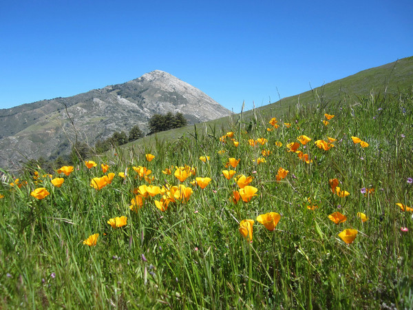
The meadows on East Molera Ridge burst with color during the spring producing one of the best coastal wildflower displays along the Big Sur Coast. The top of Post Summit provides a logical culminating destination with sweeping views of the coast and the interior Ventana Wilderness from a perch 3,455 ft above sea level. The East Molera Ridge Trail begins along a dirt road behind a white barn at the main parking area for Andrew Molera State Park. The trail goes under Highway 1 through a tunnel and then heads uphill, soon joining a wider trail that heads up through oak woodland and then chaparral. The path narrows to single track at the base of the ridge. On this day there was a stunning display of California poppy in incredibly dense patches. The density and vibrant orange color of these flowers was simply amazing. Continuing up, the single track makes a long switchback across the steep slope with views improving with each step. Ultimately the designated trail ends at a point on top of the ridge with a strip of redwoods and views across the Little Sur Valley to Pico Blanco.


 From the end of the official trail, an informal use path continue south along grassy ridges and wonderful meadows for a couple miles. The views of Point Sur, Andrew Molera, the LIttle Sur Valley, and Pico Blanco are remarkable and improve as you progress up the ridge. Pico Blanco, or “white peak,” is aptly named with a large deposit of exposed white limestone composing its distinctive pyramidal summit. The peak forms an aesthetic background for the wildflowers on East Molera Ridge and begs to be climbed! The grassy meadows end at a knoll (2,500 ft) and the final 1,000 feet of ascent to Post Summit is on a steep path through brush (fairly tame by Ventana standards). Note that there are ticks in this brush so make sure to check your skin and clothing after passage. Soon enough we were on the summit and enjoying the views. One can continue along the use paths via a route to Manuel Peak and Pfieffer Big Sur State Park via Cabezo Preito. This route along the ridge crest was obvious, but a continuation of the tick-infested brush is inevitable. On this day, we decided to forgo the ticks and bushwhacking and returned the way we came, enjoying even better light for photography while coming down through the wildflower meadows. The aesthetic loop to Manuel Peak, down to Big Sur Valley, and back to Andrew Molera is definitely on my list for the future, although the best views and scenery are on the grassy meadows of the East Molera Ridge portion.


Stunning images! Very nicely composed. My kind of nature photography. Keep up the good work. I gotta get out to Big Sur one of these days.
I have to thank you for the efforts you’ve put in penning this website. I really hope to check out the same high-grade content by you in the future as well. In truth, your creative writing abilities has inspired me to get my very own blog now 😉
水着 格安
I’ve been doing the East Molera trails for years now, and this summer I decided to move beyond Post Summit to Mt. Manuel via Cabezon Preito. It’s doable (did twice this 2015 summer), but the trail is overgrown and hard to follow, some tricky dead-ends too. What’s especially weird to me is that some of the trail has been clearly bulldozed, and I wonder how they got a bulldozer up there (3000 ft.). If anyone wants to see the path I’ve taken, with elevations, I can email them my gps image. My email address is ‘b @ n n o n . u s’.
Also, does anyone know the story behind that big radar reflector/billboard?