
El Corte de Madera Open Space preserve is one of a collection of parks surrounding Skyline Blvd near Kings Mountain, including Purisima Creek Redwoods Open Space Preserve, Phleger Estate GGNRA, Huddart County Park, and Wunderlich County Park. All told, there is over one hundred and fifty miles of awesome trail to explore in this region, only minutes away from the bustling towns of Redwood City and Palo Alto. El Corte has 36 miles of trails, with about half being true single track and the others are either fire/maintenance roads or abandoned logging roads that are narrowing back towards singletrack. El Corte de Madera is known as a mountain bike park, but it’s so big that it never feels close to crowded and the bikers have never interfered with the running (usually I only pass a group or two). In fact, I usually have a feeling of wilderness and remoteness when running in this park, paricularly on the South Leaf Trail and Virginia Mill Trails. While the other parks in the area are popular with trail runners, I have never seen another trail runner in all the times I have run at this park. I guess the mountain bikers are doing an effective job of scaring off the hikers and runners leaving all the fantastic trail running for me!
There are two loops I do in El Corte de Madera Creek, one is about 10 miles and the other is nearly 14 miles. The 14 mile route is classic and I have called it the El Corte de Madera Periphery Loop. The 10 mile route includes a nice singletrack descent on the Methuselah Trail and a single track climb on the Giant Salamander Trail. I drew in the routes on the map with the red dots indicating the periphery loop and the yellow dotes indicating the cut-off portion for the shorter 10 mile loop.
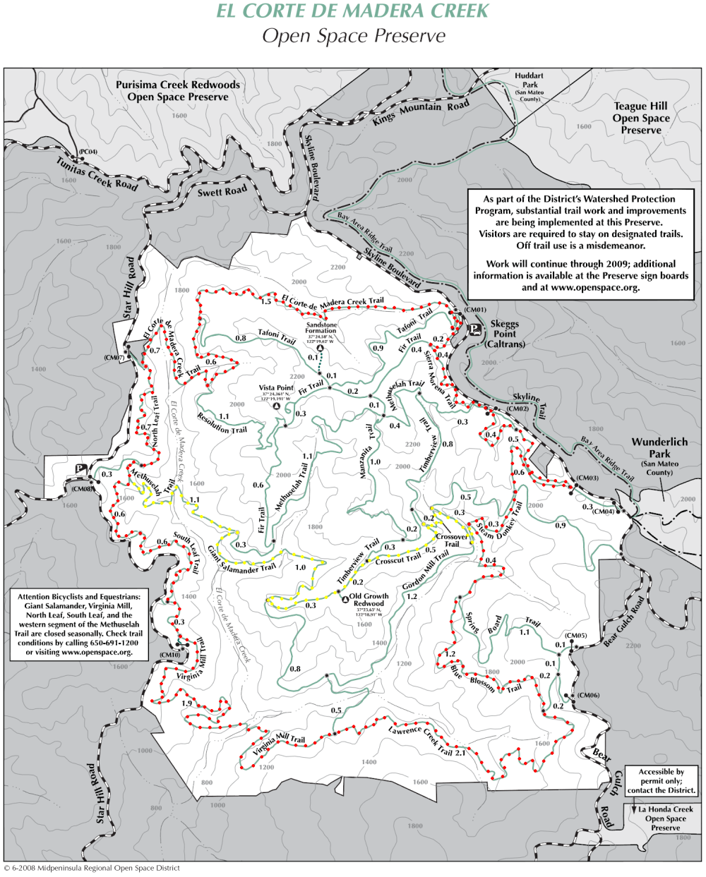
As I mentioned, the periphery loop is a classic Bay Area trail run providing a great tour of the park. The loop is almost entirely under forest canopy of second growth redwood, douglas fir, and hardwood with numerous streams. There is a section of abandoned logging road on the Virgina Mill and Lawrence Creek trails, but they are narrowing back to single track as the forest takes on a mature, natural look making them quite pleasant. Don’t expect to run a blazing pace on this loop with subsantial elevation gains and technical, narrow trails, particularly the portion on the South Leaf Trail. This loop takes me between 1:54-2:00 with moderate effort which yields a pace of about 8:10-8:30 per mile.
This drainage has a long history of being logged several times over between the 1860’s and the turn of the twentieth century. However, aside from some stumps, it’s starting to become hard to tell this place was ever logged. One hundred years later, the redwoods are getting big, the streams are clear, and wildlife is thriving. It’s amazing how it has recovered back to a pristine and beautiful state after all the destruction and distrubance that humans wrecked upon it.
The run starts at 2,200 ft along Skyline Blvd and any run goes down off the ridge so make sure to leave something in the tank because you are going to be climbing on the way out! In fact, the periphery loop drops to the lowest point in the park at ~750 ft, and combined with all the ups and downs, you have about 2,000 ft of gain from the low point of crossing El Corte de Madera Creek along the Virginia Mill Trail to get back to the car.
Aside from the loops I have outlined, the other good singletrack trails in the park are the Resolution Trail and Manzanita Trail. In addition, both of these trails offer nice views of the park and out to the Pacific Ocean.
10 Mile Loop:
- Start – Sierra Morena Trail
- Right on Fir Trail (turns to pavement)
- Left on connector shortly thereafter
- El Corte de Madera Creek Trail
- Left on North Leaf Trail
- Left on Methuselah Trail
- Right on Giant Salamander Trail
- Left on Timberview Trail
- Right on Crosscut Trail
- Right on Crossover Trail
- Right on Gordon Mill Trail
- Left on Steam Donkey Trail
- Left then immediately right onto Gordon Mill Trail
- Left onto Sierra Morena Trail
14 mile Periphery Loop:
- Start – Sierra Morena Trail
- Right on Fir Trail (turns to pavement)
- Left on short connector
- El Corte de Madera Creek Trail
- Left on North Leaf Trail
- Left on Methuselah Trail
- Right on South Leaf Trail
- Left on Virginia Mill Trail
- Right on Lawrence Creek Trail
- Straight onto Blue Blossom Trail
- Right on Steam Donkey Trail
- Left then immediately right onto Gordon Mill Trail
- Left onto Sierra Morena Trail

Here’s a great 23-miler linking Wunderlich and El Corte de Madera that I did a while back (you can skip the “detours” which were there because it was one of my first times there:
Wunderlich/El Corte de Madera Creek. Up via Alambique/Skyline. Sierra Morena, detour to Sandstone, detour to Vista Pt., Methusalah, Giant Salamander, detour to Old Growth Redwood, Timberview, Lawrence Creek, Blue Blossom, Steam Donkey. Down via Alambique, Bear Gulch, Redwood, Madrone, Bear Gulch.
Hi Steve – thinking of doing this route from Wunderlich parking lot for about 17-20 miles. Do you have a map you can share? Thanks! – karen