
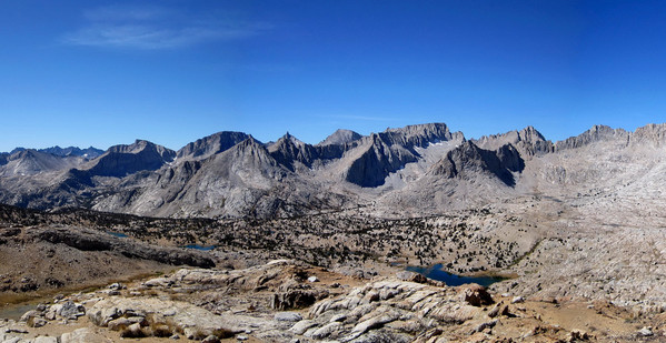
I designed a single large loop that entails nearly 40 miles and 14,000 feet of elevation gain with spectacular views into the heart of the Southern High Sierra. I call the route the “Stanford Loop” because it encircles 13,963 ft Mount Stanford, which is known as the “shyest” major peak in the Sierra because its position makes it only prominent from a small area. The loop includes four passes, two over the Sierra Crest (University Pass and Kearsarge Pass), and two over the Kings-Kern Divide (Forester Pass and Milly’s Foot Pass).
There is extensive off trail travel, first in the climb up and over University Pass, and second in the traverse of Upper Kern Basin to Milly’s Foot Pass and down to Lake Reflection. The travel in the second off-trail portion is particularly arduous and cumbersome with extremely loose (kitty litter) class 3 downclimbing from Milly’s Foot Pass and several thousand feet of loose talus fields to negotiate in the descent to Lake Reflection. In all, the loop took me 13 hours and 45 minutes. Despite the substantial and grueling effort that is required to complete this loop, I think it is the greatest single day tour of the Southern Sierras. Obviously, my travels in the Sierra are not thorough, but this one will be tough to beat. The route is a highlight reel and I was treated to constantly changing views, including Center Basin, Upper Kern Basin, the Kings-Kern Divide, the Great Western Divide, Lake Reflection, Kearsarge Pinnacles, the list goes on. The remote and infrequently visited Upper Kern Basin is especially memorable with close views of the Great Western Divide. This area is typically only reached after a multi-day backpack and I did not see anybody from the JMT all the way to East Lake. This route is a gem!
Complete Trip Report with dozens of photos here.
Aerial Map and splits after the jump!

Location (Elevation): Time Elapsed / Split / Real Time
Onion Valley TH (9,192 ft) : 0 / 0 / 06:05
University Pass (12,640 ft) : 1:48 / 1:48 / 07:53
Forester Pass (13,057 ft) : 4:02 / 2:14 / 10:07
Milly’s Foot Pass (12,240 ft) : 6:38 / 2:36 / 12:43
Jct Bubbs Creek Trail (8,136 ft) : 10:02 / 3:24 / 16:07
Kearsarge Pass (11,760 ft) : 12:30 / 2:28 / 18:35
Onion Valley TH (9,192 ft) : 13:45 / 1:15 / 19:50
Complete Trip Report with dozens of photos here.

Wow, I was just cruising through some of your adventures back there in the Sierras – man, this one was insane! That was an epic loop. Brutal looking at the last climb with the sun going down – got to make it back to the car!! Awesome inspiring stuff – Gus