The Hooper Senger Loop is an aesthetic 27.6 mile complete loop in a scenic region of the High Sierra including carry-overs of Mount Senger and Mount Hooper. Since the region is well west of the crest, the topography and summits are not high relative to the crest, but the views are spectacular and the large lakes that fill the broad bowl north of Selden Pass are wonderful. The route includes about 12 miles of off-trail travel, but for the most part it’s efficient and enjoyable with large sections of granite slabs and alpine meadows. GPS route here. Full photo album here.

The most unaesthetic part of the route is getting to the trailhead at Florence Lake. While technically all “paved,” the drive is anything but a smooth ride along a narrow, winding road that takes just as long as Google maps says it will. Expect it to take even longer if it’s a busy weekend and you run into oncoming traffic that requires careful passing. In particular, the road conditions in the final 7 miles after the final turnoff to Florence Lake are atrocious. The road is riddled with deep potholes and pavement that is so warped and eroded in spots that average speed is only around 10 mph. This is a perfect example of how severe neglect for pavement makes it ultimately worse than if it had never been paved all. At Florence Lake the recreation infrastructure, including campgrounds, parking lots, signs, pit toilet, and picnic tables, are very dated and literally falling apart. It seems the heyday for this area was decades ago and it’s hanging on to fractured pavement and broken picnic tables. On a Friday in October there was nobody else in the parking lot.

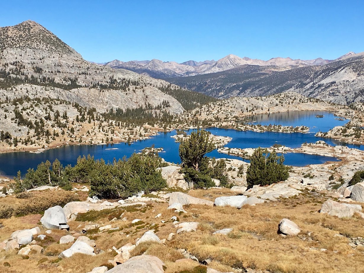
Fortunately the difficultly of the drive is more than compensated by the scenery to be found on the Hooper Senger Loop. The ideal way to do the loop is counter-clockwise leveraging the runnable miles early on and gaining the elevation to Mount Senger via the friendly grade of the John Muir Trail as it climbs to Selden Pass. The first 4 miles traverse around Florence Lake before crossing the South Fork San Joaquin River. The trail continues to Double Meadow and then Blayney Meadows passing through several nice groves of aspen. The trail undulates but is generally runnable all the way to the junction with the JMT connector at mile 9 . Between the boat landing and Muir Trail Ranch the trail oftentimes parallels or even shares the same track as a double track. It looks like the Muir Trail Ranch occasionally uses the double track with a rugged four wheeler to carry supplies or emergencies. Soon after passing the Trail Ranch one reach the JMT connector which makes a short, relatively steep climb to the JMT. However, after joining the JMT the climbing is nicely graded on long switchbacks. Along this climb the forest transitions from aspen, juniper and Jeffrey pines to whitebark pines. After 2.5 miles of climbing, the trail levels off near Senger Creek in a pure stand of beautiful whitebark pines. The trail meanders along this bench with gradual climbing in the dense whitebark pine forest before reaching the pretty Sallie Keyes Lakes basin. For Mount Senger, leave the JMT at the southernmost, smallest of Sallie Keyes Lakes. A black dot to the west of this lake on the USGS denotes a snow survey cabin, which sits in a beautiful stand of whitebark pine near the lake. Head northeast from the cabin, at first through forest, but then emerging into alpine slopes of rocks and gravel. Curve into a shallow gully with somewhat arduous climbing on sandy slopes. The final few hundred feet of climbing transition to large talus blocks interspersed with clumps of stunted whitebark pines. The summit area is broad but the best views are on the northside peering over the north face, and they are impressive. To the northeast is the remote but expansive Three Island Lake and to the northwest is Marie Lake, one of the more beautiful bodies of water that the JMT visits. Seven Gables and Gemini are close at hand as well as the next destination, Mount Hooper, with its characteristic triangular profile. Farther afield, there is a great view of Feather Peak, Mount Humphreys, Goddard Canyon and the Evolution Region.


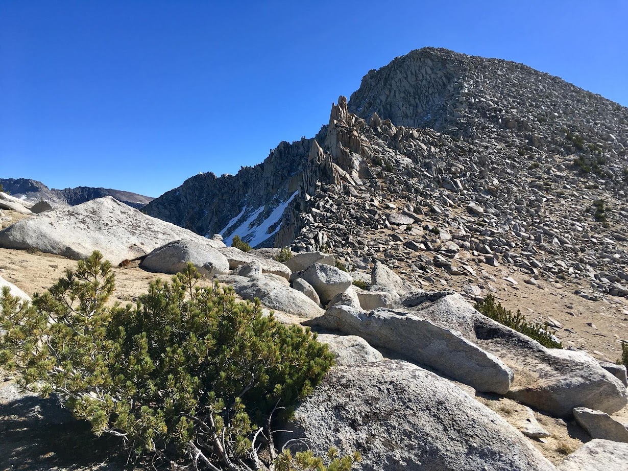
From Mount Senger, descend to the obvious saddle between it and point 12,068. Continue west to a small pass northeast of point 12,068. From this pass descend steeply on gravel, rocks and sometimes snow and ice depending on snowpack. The angle lessens after a couple hundred feet and aim for skier’s right to transition to friendly granite slabs instead of hellish moraine rubble. These granite slabs and meadows can be pieced together all the way down to Marie Lake and the JMT making for a very efficient descent. Depending exactly where you join up with the JMT will dictate whether you simply step over the trail or utilize the path for a short distance. Either way, the cross country travel is relatively easy throughout this region. After leaving the JMT, head west passing though pleasant meadows and granite slabs aiming for Mount Hooper, which towers above with its recognizable triangular shape. Make sure to look back at the deep blue waters of Marie Lake with it’s intricate granite islands and peninsulas. After ascending a headwall, the large, oval-shaped Rose Lake comes into view. A short section of talus hopping ensues before reaching a pair of alpine tarns nestled in a cirque beneath Mount Hooper. In October, one of these tarns was frozen over a half foot thick while the other tarn was ice free. What a difference a few feet makes in the mountains!

From these tarns head for the obvious notch southeast of Mount Hooper. At this notch it is not possible to scramble up to the slopes above without more technical rock climbing. Instead descend a couple hundred feet on the west side of the notch to find a break in the cliff band that spans most of the south face of Mount Hooper. The most difficult scrambling (aside from the summit block) is getting through this third class cliff band. After the cliff band the slope eases and turns into a mix of talus, sand and stunted whitebark pines. After a somewhat long slog the summit block presents itself, a very unique pinnacle with a boulder perfectly balanced on top of other boulders.

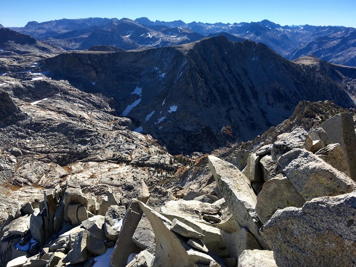
The easiest route rounds the west and north side of the pinnacle with a couple 3rd/4th class exposed moves to surmount the balanced boulder. A fifth class route exists via a crack on the south side. Considering the exposure, the 4th class rating for the easiest route is appropriate, especially because reversing the move on the way down is more difficult. The register is located beneath the summit pinnacle. Mount Hooper has a grand summit view. With it’s position well west of the Sierra crest, the view encompasses virtually the entirety of the High Sierra from Mount Lyell to the Kaweahs. The view down to Rose Lake and across Marie Lake to Seven Gables, the Mono Divide and peaks of the Abbott Group is particularly inspiring. Similar to Mount Senger, the view south includes a great angle to Mount Humphreys and the Evolution Region.

From Mount Hooper it’s only 8 miles back to Florence Lake with three of those miles on road, but the other 5 miles are steep and rugged as 5,000 feet is lost off trail. This rapid loss of elevation is certainly easier on the descent. The most difficult part of the descent is the initial drop to the shores of Chamberlain Lake. Traverse west from the summit and then drop into a broad gully with talus and sand. A small meadow is reached around 10,900 feet. From here it may be tempting to descend to the shores of Chamberlain Lake but there is a granite cliff impasse along the east shore that drops directly into the lake and extends up a couple hundred feet from the lake. Instead, it is easiest stay above the lake contouring above this impasse before descending to the sandy shores. Chamberlain is a wonderful alpine lake fringed with whitebark pines and nestled in a rugged cirque.

Cross the outlet stream of the lake and descend granite slabs and forest generally paralleling the stream. At 9,600 feet bear left traversing away from the drainage and onto a spur ridge. From the spur ridge, make an almost direct descent down to the Diversion Dam. There are many variations in exact path with cairns in seemingly random spots across the hillside. Don’t worry too much about following cairns and instead keep the bearing down the ridge following the path of least resistance. This is a remarkably quick descent considering the amount of elevation lost and the off-trail nature. With good micro-navigating one can avoid most of the brush. There, however, plenty of spots to get disoriented or take a more arduous line. For the most efficient results it’s best to carry a GPS unit or phone with mapping and consult positioning occasionally to make sure one is in the vicinity of the correct line. At the diversion dam, follow the 4wd dirt road a short distance before left at a junction. The dirt road improves and it’s mostly a flat run to Jackass Meadow Campground. At the campground the road is paved for the last mile but includes a final climb above the dam before reaching the Florence Lake parking area to close out the loop. GPS route here. Photo album here.