
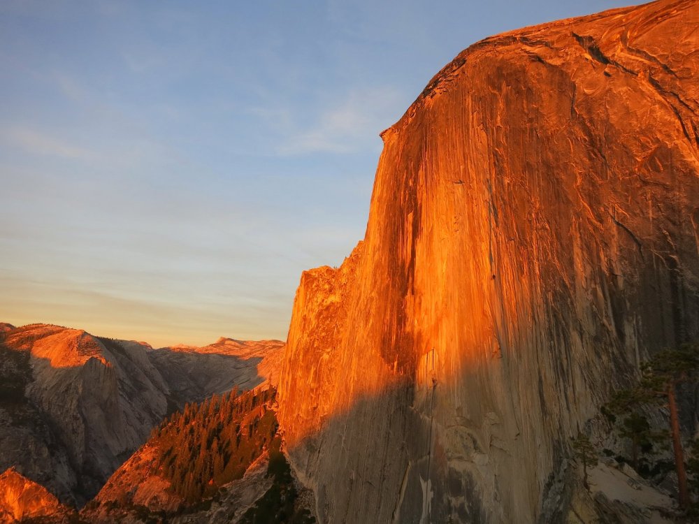
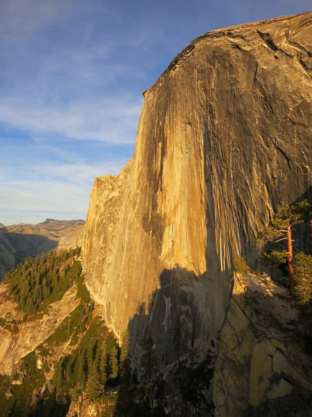
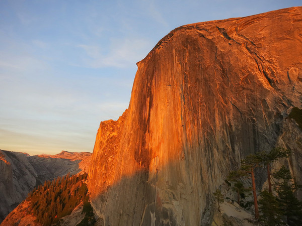
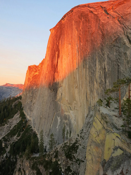
Two spots are referred to as the Diving Board on Half Dome. The most commonly visited, but unofficial diving board is located near the summit on a small overhanging lip above the precipitous northwest face. This feature has also been named “The Visor” and is the preferred name to differentiate with the official Diving Board (as labelled on the USGS topographic maps) located just west of Half Dome and directly below the northwest face. Discussion of the Diving Board hereinafter refers to the official Diving Board. The Diving Board is the location of one of Ansel Adams’ most famous photos, Monolith, the Face of Half Dome, taken in 1927. Ansel was mesmerized by this location and described it as a “wondrous place… a great shelf of granite, slightly overhanging, and nearly 4000 feet above its base…the most exciting subject awaiting me.” 87 years later the Diving Board is just as captivating with the perspective of Half Dome from the Diving Board simply spectacular. The northwest face rises a sheer 2,000 feet and takes on the appearance of a colossal skyscraper. Most of the day the face is in the shade but in the afternoon it is slowly “revealed” from left to right as the sun progresses toward the western horizon. Ansel Adams captured this transition beautifully in his photo, remarking that he saw “the majesty of the sculptural shape of the Dome in the solemn effect of half sunlight and half shadow.” Ultimately, the entire face is illuminated by the afternoon sunlight and the evening progression brings an array of colors from grayish white in the late afternoon to yellow in the evening to orange at sunset and finally reddish at alpenglow.


 The Diving Board is not far from the hustle and bustle of Yosemite Valley, but no trail reaches the point and any route requires some navigation and route finding skills. The most common and easiest route utilizes a use path that starts above Vernal Falls that travels behind Liberty Cap and Mount Broderick to Lost Lake. The use path continues past Lost Lake to a small saddle between Mount Broderick and Half Dome and then descends on the other side of the saddle before beginning a climb up steep slopes to the Diving Board. The more scenic and aesthetic route, known as “The Ledges” takes a different use path uphill from the Broderick-Half Dome Saddle to a series of well-placed ledges that cut across a granite slope. The Ledges route is the rock climbers’ approach to the popular Snake Dike route and other rock climbs in the vicinity. With close attention to cairns marking the path of least resistance, most brush can be avoided on this approach route. When the route reaches the ever-steepening cliffs of Half Dome’s southwest face, the ledges cut across the granite to climbers left. The various ledges are separated by short sections of class 3 climbing and a couple friction moves on the granite. From the ledges there are excellent views of Little Yosemite Valley, Cascade Cliffs, Bunnell Point, Mount Starr King and Mount Clark. Beyond the ledges, the approach switchbacks up to the start of the Snake Dike route. For the Diving Board, leave the approach route before it reaches the base of Half Dome and traverse right across lightly bushy terrain to a forested area in a small bowl. From the forest, travel up steep gravel slopes for the final couple hundred feet of vertical to the Diving Board.

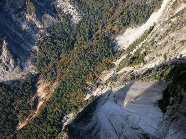

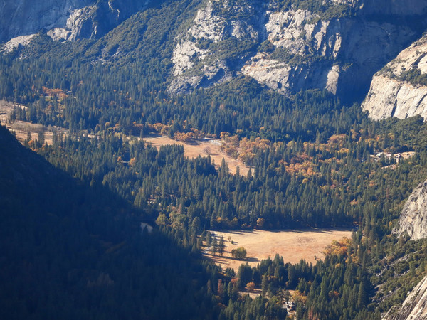
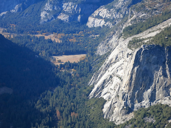
The view from the Diving Board is remarkable. Aside from Half Dome’s massive northwest face front and center, North Dome, Basket Dome and Mount Watkins are prominent across Tenaya Canyon. Most of the major features of Yosemite Valley are visible including Glacier Point, the Royal Arches, Washington Column, Yosemite Falls, Eagle Peak and El Capitan. The view immediately below from the overhanging rock is vertigo-inducing with nearly 3,000 feet of air to the floor of Yosemite Valley. On this day, the black oaks and maple trees in the Valley were in full fall color adding further intrigue to the view at the bottom of the precipitous drop. An alternative approach route to Lost Lake is the small gully between Liberty Cap and Mount Broderick. This narrow corridor is situated between too massive, sculpted granite features and is worth the extra time and effort versus the easy usetrail above Vernal Falls. The route to this corridor between Liberty Cap and Mount Broderick begins at the point where the Mist Trail touches the granite of Liberty Cap. The use path traverses alongside the base of of Liberty Cap before dropping into the gully. Once in the gully it’s fairly obvious to head up the narrow corridor passing by some pine and fir trees along the way and a hanging valley with a meadow. The final portion enters a forest of fir and aspen before joining up with the primary use path to Lost Lake. The first dozen or so photos below are from this alternative route through the Broderick-Liberty Gap corridor and the remainder are from the Ledges Route and the Diving Board in general chronological order as the sunlight exposed the northwest face of Half Dome and the subsequent evening light progression. The Diving Board is certainly a spot I will return to experience in different season with varying light angles and clouds. I also hope to visit the spot when it is snow covered. 


Your photos are amazing!
incredible. And your timing is uncanny, as I was just researching this topic this morning!
Here’s a good one of the diving board: https://www.google.com/url?sa=i&rct=j&q=&esrc=s&source=images&cd=&cad=rja&uact=8&ved=0CAcQjRw&url=http%3A%2F%2Fwww.mountainproject.com%2Fv%2F105971849&ei=0bGIVOqQEYnYoAS23ILgDw&bvm=bv.81456516,d.cGU&psig=AFQjCNGr7XOoQSS3XlE2aO9G_uz_J8t43Q&ust=1418330964590482
Thank you for the write up!!! Ive been to the diving board, a great hike! but went around Liberty cap, I will say the on the “Ledges” and the friction holds, it’s a long slide if you slip… It was also good to find out about the alt. route; the small gully between Liberty Cap and Mount Broderick. I’ll have to try it out, maybe down the first time, Thank you again