

The Silver Divide is a spur of the Sierra Crest south of Yosemite and Mammoth Lakes in the John Muir Wilderness. Unlike the Sierra Crest which is oriented from northwest to southeast, the Silver Divide is oriented from west to east. The divide is entirely under 12,500 feet, which is modest in elevation compared to the Sierra crest and neighboring peaks to the south and north. At first impression the region might also appear to be less rugged than neighboring regions and therefore less meriting of attention. Moreover, the area has much longer approaches compared to virtually anywhere eastern Sierra. Thus, the Silver Divide region is often overlooked. In fact, the vast majority of visitation in the region is confined the John Muir Trail which crosses the divide at Silver Pass. However, the Silver Divide is a gem of the Sierra with an abundance of spectacular alpine lakes, grand vistas, miles of glacial polished granite and solitude. This is also a paradise for efficient off-trail travel with numerous class 2 passes over the divide providing many possibilities for route designs or simple wandering. The western end of the divide, containing the namesake Silver Peak, is probably the least visited, but this where the Silver Divide is arguably at its best as the lakes and scenery are simply delightful. The Silver Peak Loop that I describe in this post incorporates much of this amazing terrain on the western end of the Silver Divide and includes summits of Silver Peak and Sharktooth Peak, passage by the collection of outstanding alpine lakes on the east and north sides of Graveyard Peak, and the fantastic Margaret Lakes Basin. The 32+ mile loop includes considerable off-trail travel and some remote sections of trail that are very faint so off-trail travel skills and experience with map/GPS are required. Full photo album here.


Logical access for the west end of the Silver Divide begins at Lake Edison after a long, winding and bumpy ride on the Kaiser Pass and Lake Edison Roads. Start on the Lake Edison Trail and soon branch to the left on the trail to Goodale Pass. After an ascent the trail flattens at Graveyard Meadows before resuming its ascent to Upper Graveyard Meadows. Here, leave the Goodale Pass trail and take a short spur trail that makes a steep climb to Graveyard Lakes, a string of beautiful alpine lakes nestled beneath Graveyard Peak with steep granite slabs, meadows and whitebark pines. The trail ends at the lowest lake, but a use path continues to the second and third lake. From the third lake turn right and ascend easy slopes to the largest lake. A broad granite dome is positioned at the center of the lakes and provides a superb panoramic view of the region, especially the lower three lakes. From the largest Graveyard Lake it’s a straightforward ascent up to a low 10,700 ft saddle immediately above the lake. The descent off the north side of the saddle is more arduous with some talus and loose rocks, but fairly efficient by high Sierra standards, and one is soon deposited in a lovely, flat tundra-like meadow area. Continue down the valley, passing a small lake, to reach the trail that descends to Peter Pande Lake.


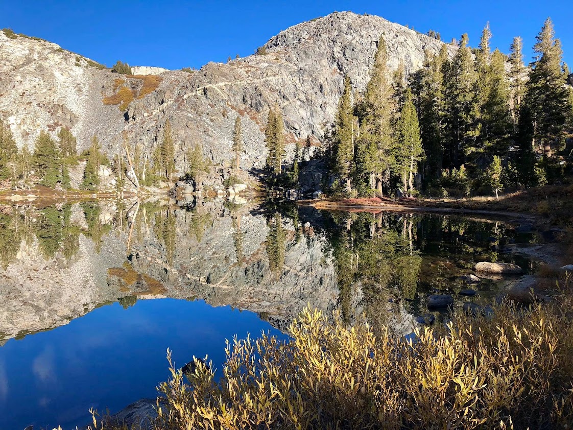
Take the trail down to the expansive Peter Pande Lake, an alpine paradise complete with sandy beaches, granite cliffs descending straight into the water, magnificent vistas to the Silver Divide, and old growth Whitebark Pines. From Peter Pande Lake the next destination is Anne Lake. One can either follow the west shore of the lake or ascend to a ridge separating Peter Pande Lake with Olive Lake (Point 10,283). This ridge provides excellent views in all directions and conveniently leads to Minnie Lake and then Anne Lake. Anne Lake is particularly charming with its crystal clear waters situated underneath the pinnacles and smooth granite slabs that compose the north side of the Silver Divide in this region.


At Lake Anne turn west and ascend a broad granite ramp to 10,800 ft where a prominent spur ridge is crossed into the Long Canyon drainage. Begin a downard traverse staying above the headwall of Long Canyon and descend to the lower of two tarns that hang above Beetlebug Lake. Near this lower tarn one can capture a spectacular view of the smooth, glacier polished granite cliffs descending to Beetlebug Lake. From the lower tarn ascend grassy slopes to the upper tarn which is nestled among slabs at 10,700 ft. This upper tarn is perched high above Long Canyon and contains an amazing view to the colorful peaks in the vicinity of Red Slate Mountain.


From the upper tarn, ascend more friendly slabs and then a section of steep, loose talus to reach a high saddle southeast of Silver Peak at 11,400 ft. From the high saddle, Silver Peak is only 500 vertical feet above. Fortunately, the sturdiness of the rocks improves as the views continue to widen. Silver Peak, with its position well off the Sierra Crest, has a commanding view of the surrounding terrain from the Clark Range and Ritter Range to the north, to the Mono Divide and Sierra Crest to the South. To the southwest one has a bird’s eye view of Big Margaret Lake, a gem of the Sierra. To continue on to Sharktooth Peak it’s most efficient to leave the ridge crest and traverse down to a patch of whitebark pines. Lower down these pines are big enough to where travel is easy between them. Continue traversing north beneath the ridge crest below cliffs until a loose, steep slope can be ascended back to the ridge crest near the lowpoint of the divide between Silver Peak and Sharktooth. The final ascent to Sharktooth is a simple talus slog from here.


The climb of Sharktooth is not remarkable but the views are. The location has a commanding view of the Margaret Lakes basin with seven of the Margaret Lakes clearly visible along with the impressive Cockscomb rock formation. In many ways this is a better view than on Silver Peak. Descending from the Sharktooth into the Margaret Lakes basin can be achieved through a number of possible routes. I chose to head down the west ridge to around 11,050 before angling down toward Shorty Lake. Continue down from Shorty Lake to pick up the faint trail in the Margaret Lakes basin. It seems this area has not seen much visitation for some time as the trail is faint to imperceptible in spots (GPS and map recommended). As such, one is likely to find solitude in this gorgeous lake-filled basin. The crown jewel of the basin is arguably Big Margaret Lake, a large lake with an intricate granite peninsula and shoreline and numerous granitic islands. Beautiful granite cliffs and pinnacles serve as the backdrop.


The faint path continues from Big Margaret Lake up and over a pass next to the Cockscomb before descending to Fern Lake and then down to near Coyote Lake. Be careful to not miss a junction in the meadow where the trail to Frog Lake is found. Once back in the forest on the way to Frog Lake the trail becomes more defined. Shortly after Frog Lake the trail begins a switch-backed ascent to a high saddle. Along the way a short diversion leads to a magnificent arch. After the high saddle the remainder of the route back to Lake Edison is fairly mundane. It’s all downhill to the Onion Spring Meadow OHV site and then its a 3+ mile trek along the OHV track back to Lake Edison. While most of the OHV track is actually pretty smooth, a few rough sections make it dicey without high clearance and appropriate vehicle for four wheel drive. Unfortunately the OHV rises about 400 vertical feet from its low point at Onion Spring Meadow, which isn’t much gain relative to earlier climbs, but it’s just enough at the end of the loop to make it a slog!


Incredible photos. This is an area I want to visit so bad. I don’t think I’ll be able to handle the beauty.
The photos on this post aren’t loading for me. This is an area I want to head back to and would love to see more cross country routes.