
The Forest of Nisene Marks State Park is located outside of Aptos in the Santa Cruz area. The entire park is essentially covered in a redwood forest canopy and the canyons of Aptos Creek and Bridge Creek are exceptionally lush with sorrel, ferns, and moss in abundance. The area has a long history of human extraction and destruction. At the turn of the century loggers ravaged these canyons and pulled out 24 million square feet of lumber. All logging operations ended in the early 1920’s and thankfully, nature has reclaimed these canyons. Many of the redwoods are now over 100 years old and the maturing forest is becoming very pleasant. Moreover, little evidence of the mill sites and logging infrastructure remains. For instance, what once was the Porter House, is now brush and young redwoods. Occasionally, I spotted an old cable track or rusting piece of metal.
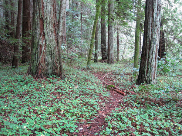
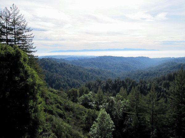
The park contains excellent single track and two remote waterfalls – Five Finger Falls and Maple Falls. On this day I ran up the West Ridge Trail and down the Big Slide/Aptos Creek Trails and then Loma Prieta Grade. I started at the winter closure gate for a total of about 16 miles. The West Ridge trail starts in a lush canyon and then ascends to the ridgeline, occasionally dropping to the south side of the ridge where it traverses small gullies. The trail is well maintained and gains elevation at a moderate pace. It’s a relatively fast trail with minimal technicality and a soft surface of redwood needles. I imagine the trails in Bridge Creek are of similar quality, and I will check them out next time I visit. The upland redwood forest is mixed with oaks and other hardwood. At 1,400 feet, 0.6 miles after Big Stump Gap, a small area of chaparral is reached providing views of Bridge Creek Canyon and Aptos Creek Canyon down to Aptos, Santa Cruz, and the Ocean. After the viewpoint, the trail passes through a nice stand old growth upland redwoods, before reaching the West Ridge Trail Camp, which is currently closed due to budget restrictions. A 1.5 mile section on fireroad was followed by a turn onto White’s Lagoon Road and then the Big Slide Trail.

There is little evidence of use on the Aptos Creek Trail and Big Slide Trail because Aptos Creek Trail has been closed since January 2007 due to a massive landslide. Big Slide trail is followable, but it is covered in a thick layer of leaves and small debris. The trail descends through a generally bland open redwood forest before reaching the Aptos Creek Trail, which runs a couple hundred feet above Aptos Creek. A use path descends down to the stream and up to Five Finger Falls (see Vimeo Video). This use path is overgrown and eroded in spots, but the setting is very lush with moss covered maples and a carpet of redwood sorrel in the redwoods. Aptos Creek is crossed and the canyon becomes narrower with Five Finger Ferns clinging to the rock walls. Around a corner lies Five Finger Falls, which tumbles around 25 feet into a cavernous rock formation. The stream that feeds Five Finger Falls is a relatively small tributary so there is never a great volume of water, although I imagine it is more impressive after a heavy rain. Continuing down the Aptos Creek Trail, I came across the landslide area that has closed the trail since January 2007. An impressive impasse was created and the trail will need significant rerouting when it is reconstructed. Others have sought access to upper Aptos Creek and use path exists which goes up and over the rock cliff using a series of rope handlines.
Overall, The Forest of Nisene Marks has some great trail running and I will definitely return to explore the Bridge Creek Trail and Maple Falls.
More photos after the jump!


Leor,
I enjoyed your account and description of the Aptos Creek Trail. I realize this was written about a year ago, but I’m interested to know how you returned to your starting point. In an effort to reach the “epicenter” of the Loma Prieta earthquake, via a more challenging route, we did what is described as an 11.6 mile loop: the fire road to the big slide trail to the aptos creek trail. The aptos creek trail is exactly as you describe and when we hit the landslide areas (at least two, maybe three of them) we hiked down to the creek basin and scrambled through the slightly hairy “impressive impasse” that you describe. When we regained the trail (by hiking out of the basin) beyond the slide areas, there were a number of giant redwoods across the trail…pretty clearly victims of the earthquake, although that can probably be confirmed. I’m also curious: do you think the park’s maps and other signage adequately prepare hikers for encountering the landslide areas?