
Mount Florence is one of the most prominent peaks in the Yosemite high country visible from many spots along Yosemite Valley’s rim. The peak has a sweeping 360 degree panorama of virtually the entire park. While there are several routes to climb Mount Florence, the easiest and quickest route utilizes the Rafferty Creek Trail and Lewis Creek Trail via Tuolumne Pass and Vogelsang Pass. After ascending Vogelsang Pass, one descends around 1,000 feet along the Lewis Creek Trail before setting off cross country to beautiful Lk 10,541 (around 10.5 miles from Tuolumne Meadows). The cross country travel to Lk 10,541 is fairly straightforward with some boulders and slabs. Lk 10,541 is at the foot of Mount Florence with a stellar view up a remote valley to Mount Simmons, Mount Florence and other rugged unnamed points along the ridge. Beyond Lk 10,541 is a short steep section of talus up to the ridge crest at 11,000 feet. From the ridge, it’s a straightforward class 2 scramble up another 1,600 feet to Mount Florence’s summit – a great workout.
One of my favorite photos of the day was a 360 degree annotated view from the summit of Mount Florence.

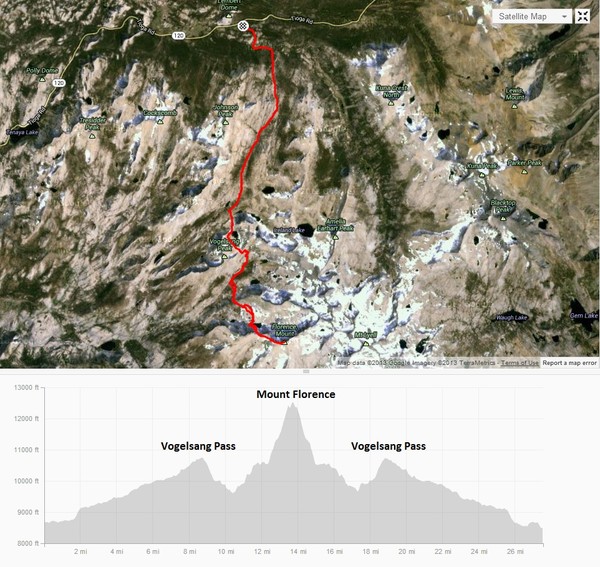
I enjoyed the summit for well over a half hour, enjoying the views, which include the heart of the “roof” of Yosemite at Mount Lyell and Maclure and the entire Cathedral Range. Mount Florence also provides a clear vantage of the Merced River Valley to Half Dome, Clouds Rest and points along Yosemite Valley’s rim. After the summit rest, I retraced my steps back to Tuolumne Meadows. Instead of an out-and-back, one may descend Florence’s south ridge and traverse cross-country up and over the ridge to Lewis Creek Basin and then the pass near Parsons Peak to Ireland Lake. This scenic route would form an aesthetic loop, but includes a substantial amount of tedious off-trail travel. Since I had a very long day planned for the following day, I decided to leave this loop for next time. Even with climbing Mount Florence as an out-and-back, the route comes in at nearly 14 miles each way (28 miles total) with over 7,000 feet of elevation gain. Below are some photos from Florence’s summit, Lk 10,541 and Vogelsang Pass. Strava route here.


One CommentAdd yours