
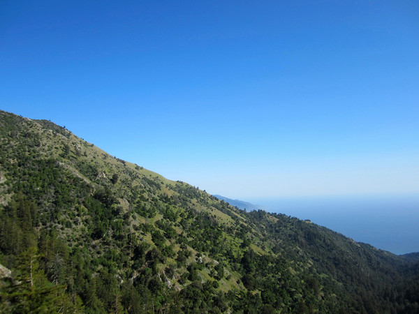
Cone Peak via Stone Ridge Direct is a tremendous off-trail hike and worthy of the title “Sea to Sky.” Stone Ridge is arguably the most prominent ridge in all of the Big Sur coast rising nearly 5,000 ft from the Pacific Ocean at Limekiln canyon to the summit of Twin Peak. It’s an extremely aesthetic route remaining on the ridge crest virtually the entire route and featuring outstanding and uninterrupted scenery with a panorama that broadens with each step. Total mileage from the Pacific Ocean to the summit of Cone Peak at 5,155 ft is only 7 miles via this route, but entails over 6,000 ft of gain (route on Strava). Fortunately, the non-stop views from the ocean at Limekiln Beach to the summit of Cone Peak distract from the difficult nature of this cross-country route. This route features amazing diversity of ecosystems including redwoods, grassland, oak woodland, chaparral, Coulter Pines and a rare forest of Santa Lucia Fir and Sugar Pine on the north side of Cone Peak. Wildflowers were out in force with fields of lupine and California poppy. This is a route I look forward to doing many times in the future, and especially after a winter snow event when I imagine Stone Ridge becomes even more striking.


The route begins with a touch of the ocean at Limekiln Beach. A short walk along Hwy 1 brought us to an old road which has become an overgrown single track trail. The path gradually ascends and enters Limekiln Canyon, passing through a redwood grove with a marvelous carpet of redwood sorrel. Evidence of the 2008 fires remains on the trunks, but the forest has largely regenerated. Beyond the cool and lush redwoods, the track ascends into the chaparral with the foot of Stone Ridge coming into view. The first climbs pass through steep meadows up to a crossing of the Stone Ridge Trail, which travels perpendicular to the ridge crest. From this point, the remainder of the route up the ridge and over from Twin Peak to Cone Peak was fully in view. This section along the grassy ridge was spectacular with some very steep and sometimes loose “steps.” Ultimately, the meadows ended and we entered into a brushy section for the last push up Twin Peak. This portion also contained a rare and unique pine species, the Coulter Pine, which produces the largest pine cones in the world that can weigh up to 10 pounds. After a quick stop on Twin Peak, we headed down the ridgeline connecting Twin Peak and Cone Peak. The easiest way to connect Twin Peak to Cone Peak is to follow the crest of the ridge between the summits beyond the low point between the peaks and then up the ridge towards Cone Peak. Just before the spine of the ridge becomes cliffy, take a steep and open dirt slope on the north side of the ridge down a hundred feet or so to the Gamboa Trail. While the trail is close to the ridge further back, there are lots of down trees and festering poison oak worth avoiding. We ascended the final half mile up to Cone Peak’s summit via the Gamboa and Cone Peak Trails and enjoyed the 360 degree panorama from the top. We descended via the Gamboa Trail and Stone Ridge Trail to the lower portion of the Stone Ridge route. The Gamboa Trail and Stone Ridge Trail are in relatively good shape with trail work actively occurring on the Gamboa Trail. The Gamboa Trail contains a fascinating forest of Santa Lucia Firs and Sugar Pines. The Santa Lucia Fir is the rarest fir in the United States, endemic only to mountaintops of the Santa Lucia Mountains. The firs have a distinctive conical shape and deep green color. While not rare, the Sugar Pine contains the longest pine cone of any pine tree, sometimes over a foot long! It’s amazing to find the largest pine cones (Coulter Pines) and the longest pine cones (Sugar Pines) within close proximity high on the mountain slopes of Cones Peak. Unlike most of my posts, the following photos are in chronological order. 


Beautiful! That looks so fun! Here’s a story: I was at Prewitt Ridge (a few days before you did this hike) going cross-country on an adjacent ridge, when a local rancher with a holstered gun informed my friend and I that we were trespassing. Dude was wearing an ultramarathon shirt! He did inform us of the flora during the armed escort off his property. … hopefully that scare is a fluke around there.