
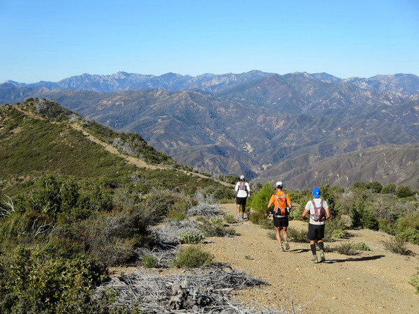
A point-to-point is the best way to maximize covering and experiencing a lot of terrain. The complete Coast Ridge route is no exception with 39+ miles of amazing and constantly changing scenery for its entire length. This aesthetic route is a masterpiece and one of the “super” classics of Big Sur and the Ventana Wilderness. The route essentially parallels the coast from south to north and is mostly right on the crest of Coast Ridge. As you might expect from a ridge of this prominence, there are wide vistas in all directions for virtually the entire route. On the west side of the ridge, the Pacific Ocean and Big Sur Coast are ever present, with views into some of the most wild and rugged drainage basins along the entire coast, including the forks of Devils Canyon and Big Creek. On the east side of the ridge are vistas into the remote interior Ventana Wilderness including the Lost Valley, Junipero Serra and the South Fork Big Sur River. Most of the elevation gain is accomplished within the first 9 miles and after one last climb up to Anderson Peak, a running-friendly dirt road provides a net gradual downhill for the final 15 miles all the way to the terminus of the Coast Ridge Road at Ventana Inn. The middle section on the North Coast Ridge Trail is the most remote and has some brushy sections and a few small blowdowns, but no major bushwhack and route finding is straightforward. Strava route here. 


The route beings with a steep climb out of the redwoods in Limekiln Canyon onto lower Stone Ridge. At the intersection with the Stone Ridge Trail, we took the trail into the West Fork Limekiln Canyon traverseing lovelly oak woodland and redwood-filled ravines. Eventually we climbed out of the canyon to “Ojito Pass” where the Stone Ridge Trail turns into the Gamboa Trail and curves into the South Fork Devils Canyon. The Gamboa Trail is one of the my favorite trails in all of the Ventana and passes through an amazing forest of Santa Lucia Fir, Sugar Pine and Coulter Pine with excellent views down canyon to the Pacific. The trail ends at a junction with the North Coast Ridge Trail which has sublime views of the surrounding terrain. After an open area, the North Coast Ridge Trail enters a spectacular sugar pine forest with a nice smooth trail covered in pine needles. The trail exits the forest near Tin Can Camp, which possesses one of the best views of the entire route. To the west is the remote, rugged and trail-less Middle Fork Devils Canyon and to the east is the imposing massif of Junipero Serra Peak. Beyond Tin Can Camp, the North Coast Ridge Trail descends through one last stand of Sugar Pine and Coulter Pine forest before exiting into a largely chaparral landscape that was burned in the 2008 Basin Complex fire. The trail is easily followed, but contains areas of brush and downfall to negotiate. The firebreak and the trail are mostly in unison on the ridge ridge crest, however they sometimes diverge when the firebreak sticks to he crest religiously while the trail will traversing across the terrain to avoid intermediary high points and unnecessary ups and downs. We mostly stayed to the trail except we took the firebreak over Mining Ridge. As the highest point between Ventana Double Cone and the Cone Peak area, Mining Ridge has a fantastic 360 panorama. We enjoyed lunch here and then continued down the east side of the firebreak to rejoin the North Coast Ridge Trail near the junction with the Redondo Trail (which leads down into Memorial Park). 


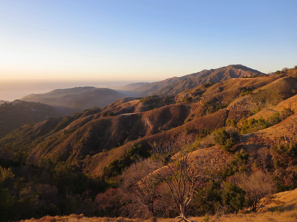
The next section was one of the best ridge sections with excellent views to Ventana Double Cone, which appears noticeably closer at this point. Along this ridge we were happy to find water at the Coast Ridge Spring (aka Redondo Spring). This indicates the spring is fairly reliable even in dry years, but with as dry as it’s been this year, I wouldn’t count on it much longer. The final portion of the North Coast Ridge Trail is becoming more overgrown. It was nice to see some pine trees survived the fire in this section as well as many new pine saplings emerging from the chaparral. After about 20 miles, the trail emerges onto the Coast Ridge Road, which is a dirt road that would take us all the way to Ventana Inn. While closed to the public vehicular traffic, pedestrians have a right of way on this dirt road that is in reasonably good shape to allow access to a few homes and private properties along the way. I made a side trip to climb Marble Peak which has another A+ view of the surrounding region. I also found a nice use path on my way down that emerges from a vegetation tunnel onto the Coast Ridge road directly across from a sign that says “Marble Peak.” I also ascended to the top of Anderson Peak by skirting fences (but not surmounting any) and ascending steep grass. The summit of Anderson Peak is federal government property with some old flight radio equipment and a few buildings. The top of the peak is paved with a signal at its center. It’s an odd sight after hardly seeing any infrastructure all day, but the summit “platform” has great views of the coast and the rugged ridge between Kandlbinder and Ventana Double Cone. After Anderson Peak, it’s mostly all downhill along the dirt road with amazing views throughout. At Timber Top we briefly left the road and ascended over Timber Top instead of taking the circuitous road. The views of the Big Sur coast from Timber Top are truly spectacular. The final section of Coast Ridge Road was marvelous with the grassy hills and Mount Manuel illuminated by the soft evening light. We arrived at the finish just as the sun had set to wrap up a special day in the Ventana.

Click on the image below for a 360 degree panorama from Marble Peak:

Note: Save for the very last image, the remaining photos are basically in chronological order. 


These photos and your description of the trail are fantastic. I was searching for some information about remote areas south of Monterey to do some astronomy and see that this Coast Ridge Road is not going to work but what a spectacular trail for running and hiking. I hope 2014 has been going well with you. -K