
October 13, 2009 was a day for the record books in Bay Area weather and a bonanza for weather geeks like me 🙂 Numerous daily rainfall records were set across the Bay Area as the strongest October storm since the 1962 Columbus Day storm battered the region. Impressive rainfall totals were tallied in the usually wet spots but also the typically drier locations. The high precipitation rates were due to the fact that this storm was infused with copious amounts of tropical moisture from ex-Super Typhoon Melor that impacted Japan last week. A strong jet stream picked up the moisture and propelled it towards the West Coast. The tropical nature of the system was also apparent today as it was quite muggy outside with temps in the mid 70s despite cloud cover. Highest precipitation totals occurred in the Santa Cruz Mountains, as expected, where several gauges recorded over 10 inches of rain and 3,486 ft Mount Umunhum tallied 13.23 inches, the highest total in the Bay Area. Highest totals produced by the system anywhere occurred in the Santa Lucia Mountains along the Big Sur Coast where some gauges topped 16 inches! Strong winds also accompanied the storm with peak gusts over 50 mph common across many Bay Area locations.
Precipitation Summary:
- 2-5 inches at Coastal, Valley, and Bay locations: SF downtown (2.48), SF Int’l (2.64), Oak Int’l (2.37), Oakland (3.86), San Jose Int’l (2.33), Stanford (3.02), Woodside (3.93), Redwood City (3.52), La Honda (4.94)
- 6-12 inches in the Santa Cruz Mountains: Ben Lomond Mtn (10.60), Mt Umunhum (13.23), Uvas Canyon (11.65)
- 5-6 in the Marin Hills: Mt Tam (7.14)
- 4-6 in the East Bay Hills
- 5.72 on Mount Diablo
More details and post-rain photos at Huddart Park after the jump!
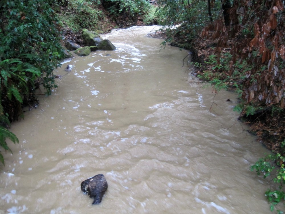
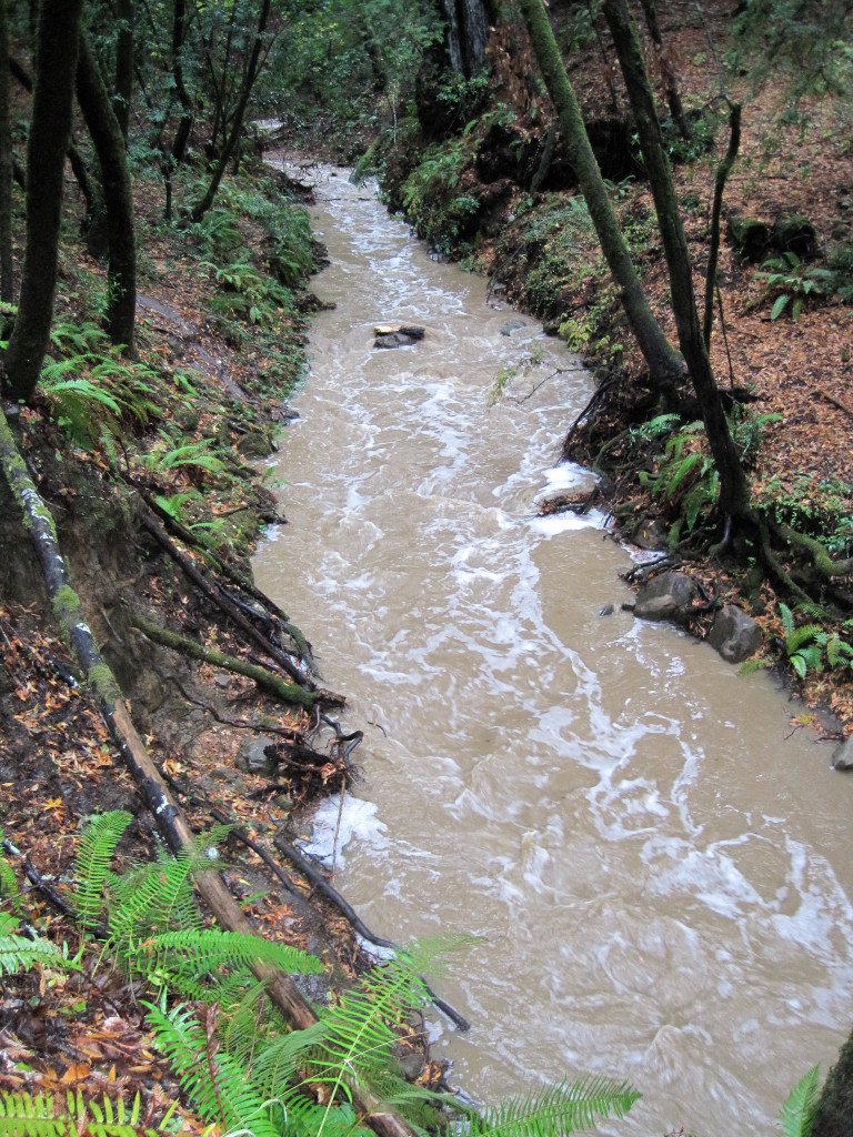
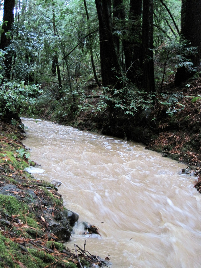
Over 6.5 inches fell on Kings Mountain and West Union Creek in Huddart Park went from bone dry to a swift and muddy flow, as seen in these photos taken shortly after the rains subsided. Last February, the storm totals in the region were similar, but the ground was wetter and there was water flowing in the streams beforehand resulting in higher volumes. While I have seen substantially higher volume, what makes this event so impressive is the rapid change from dry to wet. Since the precedent conditions were so dry, much of the rain was either quickly flushed out in the runoff or soaked up by a thirsty ground. The result was a sharp drop-off in stream levels beginning immediately after the rainfall ended with probably only 30% of the volume remaining by the afternoon of October 14th.
The question now is will the Bay Area return to a typical fall pattern of sunny skies with pleasant temperatures? Or will this storm herald more stormy fall weather? I’m going to go with the former. After all, this is California and not Western Washington. However, I do expect this winter to be wetter than average with more precipitation than the last three winters due to the strengthening of an El Nino pattern which is strongly connected to wetter than average winters in California. Since El Ninos typically only crank up the storms in California beginning in mid to late December, I’d bet on some fine fall weather yet to come.

I really expected the trails to be alot muddier than they were on Wednesday, and you are right, the ground really sucked it all up.
No way. It must be fun to slosh through the air when it’s raining like that. I noticed by your May 2008 post on the Cougar Mountain Trail series that we (the Seattle Running Company) put on that you used to live up here, so you probably noticed that we rarely have huge downpours, just a steady stream of rain throughout the fall and winter. How often does it rain there?
we rarely have huge downpours, just a steady stream of rain throughout the fall and winter. How often does it rain there?