
The Shouey-Plaskett Loop is one of the best short loops (<15 miles) on the Big Sur Coast with excellent variety including a lush redwood forest, expansive coastal vistas, picturesque grassy ridges, and oceanside views of rugged beaches and sea stacks. In fact, I enjoyed this loop so much that I returned here a couple weeks later with Erica (stay tuned for photos from that outing). The loop originates in Pacific Valley, one of my favorite spots on the coast, and comes in around 12 miles with nearly 4,000 feet of gain.


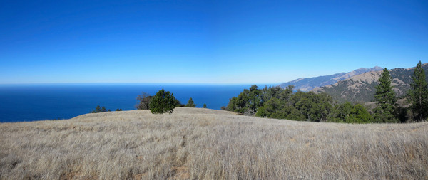
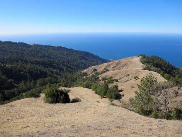
The route starts at the South Prewitt Trailhead behind the Pacific Valley Fire Station. The South Prewitt begins with some climbing on an old road and less than a mile up the trail, the Prewitt Loop veers to the left while the Willett Trail (here an old road) continues straight. The Willett Trail (aka Mansfield Ravine Trail) soon narrows into single track and switchbacks up a steep hillside amid a lush setting of redwoods with sustained elevation gain. There is some encroaching poison oak and brush in spots, but otherwise the trail is in good condition. At ~1,800 feet it is best to leave the trail and ascend a spur of Shouey Ridge. This is open forest at first and after a few minutes of climbing you pop out into grassland with marvelous views of Pacific Valley below. Continuing up the spur ridge, the views open up further, including the familiar craggy face of Cone Peak, the King of the Big Sur Coast. The spur ridge joins Shouey Ridge proper at ~2,200 ft, where a more defined use path can be found heading uphill along Shouey Ridge.Before heading up the ridge, I recommend first going down to a spectacular vista at 1,700 ft. The trail peters out on this lower portion of the ridge, but travel is easy through the grassy meadows. The vista at 1,700 ft is perched over Pacific Valley with a breathtaking panorama from Cape San Martin all the way to Lopez Point, including Sand Dollar Beach, Pacific Valley Bluffs, Limekiln, Stone Ridge, Prewitt Ridge, Cone Peak and Twin Peak. 


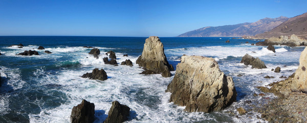
Heading back up Shouey Ridge, the amazing views never abate on the exposed ridge crest. There are some particularly photogenic Coulter and Ponderosa pines lining the ridge. After a short steeper section between 2,400-2,800 ft, the use path begins to traverse the hillside at ~2,800 ft below private property with excellent views of Plaskett Creek canyon. The use path ends at Plaskett Ridge Road, which seems to only be used by the two residents who live up there. Head downhill along the road and find more amazing views along the way; one of the prettiest roads I have ever been on! There are numerous side paths along the road that can be taken to viewpoints. Of particular interest is a series of paths that head down a spur of Plaskett Ridge to a great view of the Willow Creek drainage (we explored this area two weeks later). After a bend in the road at 2,400 feet, take another use path that follows the spine of lower Plaskett Ridge. This use path provides more stellar views before entering a pine forest and ultimately popping out on Plaskett Ridge Road for the last 1.5 miles back to Hwy 1. The views keep coming with excellent views to Sand Dollar Beach on the run down the dirt road. After a couple hundred meters on the highway, enter the Sand Dollar recreation area. A short diversion down a staircase leads to the beautiful Sand Dollar Beach (surfing, swimming, beach walking), otherwise a use trail heads north along Pacific Valley Bluffs. Exploration abounds as there are numerous interesting rock formations and beaches tucked into the seascape. Find an inspirational spot and enjoy the beautiful setting before heading back to the parking area at the Pacific Valley Fire Station. Strava GPS route here. 


WOW! That looks like a simply AMAZING place to run!