Since the non-winter travel season in the Sierra ended I’ve been fairly active in Big Sur but have not blogged on those trips, partially due to time constraints, but mostly because I have already posted on these particular routes many times in the past. The Soberanes Fire burned a good deal of the Ventana Wilderness and the resultant closure means a lot of potential new and interesting routes and waterfall explorations will have to wait until the closure is lifted. As I will explain, this doesn’t mean there won’t be any new Big Sur adventures and I’m also looking forward to winter adventures to the Sierra now that we’re finally building a good snowpack of years of snow drought.


The Soberanes Fire was the most expensive in U.S. history and caused a great deal of damage to homes and structures in the north part (outside the wilderness) where it burned through decades old chaparral fast and hot. However, from what I have seen of the burn scar in the Ventana, it looks patchy which generally reflects the fire’s slower moving, lower-intensity nature once it crossed into the Basin Complex footprint where the fuels were only 8 years old vs decades old. Make no mistake, some hillsides and ridge lines in the Ventana burned severely, but the canyons look surprisingly green. From what I can see, the ever-resilient redwoods that survived the Basin Complex in 2008 appear to have largely made it out of the Soberanes Fire as well. I am hopeful many of my favorite ponderosa pines in Pine Valley and near Pat Springs also survived. I’m also hopeful groves of the endemic Santa Lucia Fir that were fireproof enough to withstand the Basin fire also survived the Soberanes. The worst burn areas seem to be where the burnout operations took place and a “scorched-earth” strategy was intentionally implemented by fire managers to contain the fire’s spread. Other zones badly effected look like mostly south facing chaparral zones which are basically evolved to burn vigorously and grow back even more vigorously in the years after fire. It should not be forgotten that only a few years after the Basin Complex fire in 2008 many of these chaparral communities were already firmly reestablished and I have no doubt these plants will come back even more vigorously this year, especially with the very promising start to the rainy season. Overall, my initial impression is that the fire did not leave a moonscape and I’m hopeful nature will bounce back fast as it has done in the past in these mountains.

I’ll have more on my thoughts on the fire in posts to follow, but suffice to say that explorations into the wilds of the Ventana will be limited this year. I say limited because unlike the Basin Complex/Chalk Fire in 2008 which closed the entirety of the Ventana, the southern part did not burn in the Soberanes Fire leaving plenty of opportunities for adventure. This unburned region includes Cone Peak, the King of Big Sur, which is the mountain that has captivated me more than any other mountain on the planet. In addition, the South Coast/Silver Peak Wilderness was also spared fire as the Chimney Fire by Lake Nacimiento was stopped before reaching the Silver Peak Wilderness. I’ve already got a number of adventure ideas in these regions unaffected the fire.
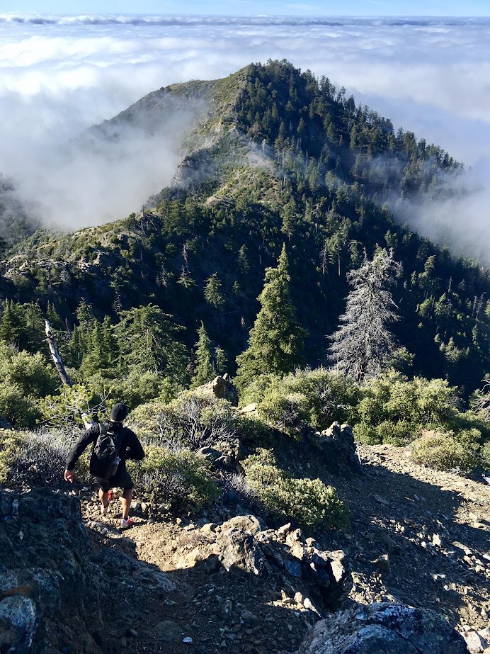
 I’ve blogged on Cone Peak many times, so there are several trips that feel similar enough to past posts that it’s not worth sharing again. However, on New Years day I joined Joey Cassidy for a unique day on the mountain that will certainly be remembered for a long time. Instead of the usual sunny and clear conditions with vistas of the deep blue Pacific, we had a dynamic scene with a relatively stable 4,000 ft cloud layer swirling around the canyons and peaks. It’s not like the clear views of the ocean aren’t stunning, but we’ve seen that dozens of times and taken thousands of photos. This was something different. The cloud layer was constantly changing and dynamic and at the perfect elevation to be dramatic from the mountain tops. Climbing up Stone Ridge in the morning we entered into the cloud layer at ~3,000 ft. Joey felt confident we would emerge from the cloud based on cloud experiences and I was a little more suspicious. There’s been plenty of times where I’ve been caught on a summit not quite high enough to emerge from the clouds. It turns out Joey was right and we emerged from the clouds into the blue sky at around 4,000 ft. While Joey called the breakout, neither of us could anticipate how the cloud layer would transform familiar sights in the high country into dramatic and constantly evolving scenes. This was a day that demanded a lot of photography and while most of the photos I’m sharing are from iPhone, Joey’s album includes amazing shots from his DSLR and it’s worth checking out every photos in the album which I’ve shared on Facebook page. To help organize those memories and share the experience the following is a photo blog of my favorite photos from the trip and a few time lapse scenes along the way. Full photo album here.


 After emerging from the cloud layer on the high slopes of Twin Peak we traversed over to Cone Peak finishing off with the West Rib scramble route which is a short and sweet scramble in an amazing setting perched above the South Fork Devils Canyon. The clouds filling the canyon and surrounding Twin Peak only enhanced the scramble and we took turns photographing each other as we climbed the pitch. At the summit we sought shelter from the fiercely cold winds by hanging out on the south side of the lookout building. This was a rare time when I actually appreciated the building as a wind blocker. Most of the time it looks like a metal trash that I’d rather see removed. After pausing for some time lapse photography we continued down the North Ridge. As we descended the wind abated and it became pleasant once again encouraging even more photography. I always marvel at the beautiful stand of Sugar Pines, Coulter Pines and Santa Lucia Firs along this narrow ridge with tremendous views of the South Fork Devils Canyon on one side and the upper San Antonio River watershed on the other side. The cloud play also continued with a tendril from Devils Cranyon cresting over the low point in the ridge. From the end of the north ridge we took the North Coast Ridge Trail to the Carrizo Trail. The upper part of the Carrizo Trail has seen a lot of brush growth since I last visited (spring 2016) with quite a bit of tall brush now encroaching. Eventually we rounded the corner into the Sugar Pine forest and left the Carrizo Trail for the Cook Spring connector use trail which passes through a lovely section of the forest. This area around Cook Spring is is a large north facing bowl, perfect growing habitat for the Sugar Pine which prefers cooler conditions and naturally resistant topography to fire. The result is the most impressive grove of Sugar Pines in the Ventana with many large and tall trees (Sugar Pines are only found in the Cone Peak region and on top of Junipero Serra Peak). Unlike the forest in the Sierra Nevada where the Sugar Pine is often a cohabitant with other species of pine, the forest here is almost purely Sugar Pine. The stately tree is tall and bears the longest cones of any conifer in the world. The weight of the cones on the trips of branches pulls branches downard resulting in horizontal branches or even download sloping branches on mature trees. The Sugar Pine was considered by John Muir to be the “King of Conifers” and I have to agree. Save for a few Santa Lucia Firs and incense cedars mixed in it’s nearly a pure stand of this magnificent tree. It’s always a pleasure to walk among the giants in this forest.


 From Cook Spring we connected back to the North Coast Ridge Trail and made an out-and-back to Tin Can Camp where one can gaze across the Arroyo Seco River headwaters to the Indians and Junipero Serra Peak. The west side of the ridge features a wonderful view of the Middle Fork Devils Canyon with it’s own stands of Sugar Pines and Santa Lucia Firs. We returned along the North Coast Ridge Trail and took the Gamboa Trail down to Trail Spring reentering the cloud layer. Trail Spring flows more like a creek after winter rains and after drinking the delicious water we headed up the Cone Peak Trail back toward Cone Peak. We traversed the Cone to Twin ridge in evening light and another extensive photography session we headed back down Stone Ridge heading back into the cloud layer and leaving the amazing world above the clouds for good, but the excitement of what we saw will stay with us much longer!


*Pictures Missing (70 %) Repost please!!!*
On Fri, Jan 6, 2017 at 7:19 PM, Leor Pantilat’s Adventures wrote:
> pantilat posted: “Since the non-winter travel season in the Sierra ended > I’ve been fairly active in Big Sur but have not blogged on those trips, > partially due to time constraints, but mostly because I have already posted > on these particular routes many times in the past. T” >
All photos are up and you can view the full album: https://goo.gl/photos/7EBc7GvGBUH7sGQg8
*42 photos Mp4’s missing!!! please repost!!!*
On Fri, Jan 6, 2017 at 7:19 PM, Leor Pantilat’s Adventures wrote:
> pantilat posted: “Since the non-winter travel season in the Sierra ended > I’ve been fairly active in Big Sur but have not blogged on those trips, > partially due to time constraints, but mostly because I have already posted > on these particular routes many times in the past. T” >
42 photos missing please repost w full caption of photos incl view compass Directions Cone Peak jewel of Big Sur!!!
Hi Galen, Sorry about the uploading issues. All photos are up now, but it’s busy at work so no time for captioning and compass directions. Enjoy the photos!!
Amazing as always! 🙂
Can you share your gpx tracks?