
Photos here. Deep within the Ventana Wilderness along a high ridge that separates the Carmel River drainage from the Big Sur River drainage lies some of the most remote, wild and unforgiving coastal terrain in the United States. Along this ridge are the three “Ventana Cones” including Ventana Double Cone, Ventana (single) Cone and South Ventana Cone. While there is a history of exploration and climbs along this ridge, Bob Burd was the first person to envision a traverse of this entire ridge in a single day including summits of all three Ventana Cones, a route he coined the “Ventana Triple Crown.” After a couple failed attempts, Bob succeeded his dayhike aspirations in 2006, a feat that has not been repeated until now. I have done several routes to get acquainted with the terrain of this amazing region including visits to Kandlbinder, the Window (aka La Ventana), Ventana Double Cone, Ventana (single) Cone and the Ventana Spires. Over time I became intrigued by the ridge and the collection of rocky summits between Ventana Double Cone and Ventana (single) Cone. Completing the Triple Crown offered a great way to explore this extremely remote and rugged stretch. The volume of experiences I’ve had in the area enabled me to carefully study the terrain and utilize the path of least resistance. Admittedly, the path of least resistance still entailed much resistance, but I knew what to expect and doing my homework certainly helped as I was able to complete the Triple Crown in 14 hours, 15 minutes roundtrip from the China Camp TH of the Pine Ridge Trail. It was both a mentally and physically challenging journey, but it was also incredibly rewarding and a route that I enjoyed a lot, as manifested by the nearly 500 (!) photographs that I took. I look forward to further explorations in this amazing region and also repeating the Triple Crown. GPS route here. Full photo album here. 
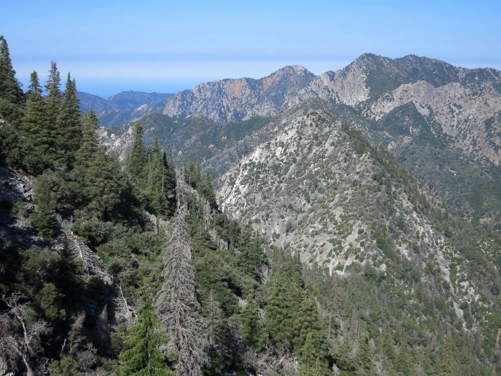
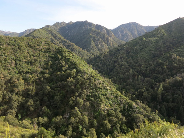
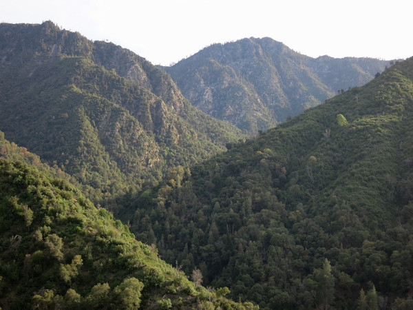
 Overview of the Triple Crown from Mount Manuel below:

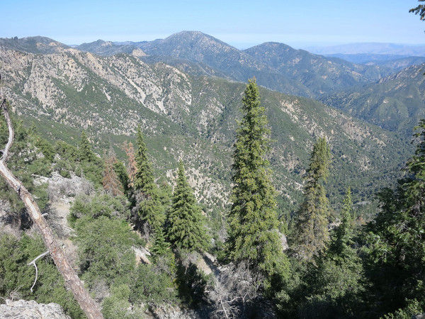
 Chaparral & Santa Lucia Firs: Much of the difficulty of the Triple Crown is due to the unavoidable bushwhacking through California chaparral, a hardy, drought-adapted mix of shrubs that covers much of the land and includes ceanothus, chamise, oak scrub and manzanita. The chaparral provides copious fuel to fires that periodically sweep over the ridges and down into the canyons. The same fires also encourage explosive reproduction of the shrubs and in as little as four years the chaparral can return as thick as ever, sometimes so thick that it is virtually impenetrable. On rocky, mostly north facing slopes, a rare forest of Santa Lucia Fir can be found. Endemic to the Santa Lucia Mountains and the rarest fir in the world, the Santa Lucia Fir is not fire resistant, but has survived in these mountains by habituating fireproof terrain on rocky slopes and the bottom of moist canyons. This amazing tree is symbolic of the Ventana Wilderness with its slender, spire-like form. The largest concentration of Santa Lucia Firs in the world can be found in the canyons and peaks of the upper Carmel River watershed. Often times, the steep, rocky terrain characteristic of the Santa Lucia Fir habitat is the ticket to efficient travel. The 2008 Basin Complex fire roared through this area of the Ventana with ferocious speed and heat leaving a maze of deadfall in spots. However, it appears the Santa Lucia Fir forest largely survived, a testament to the fir’s unique adaptability in a region where fires occur periodically.

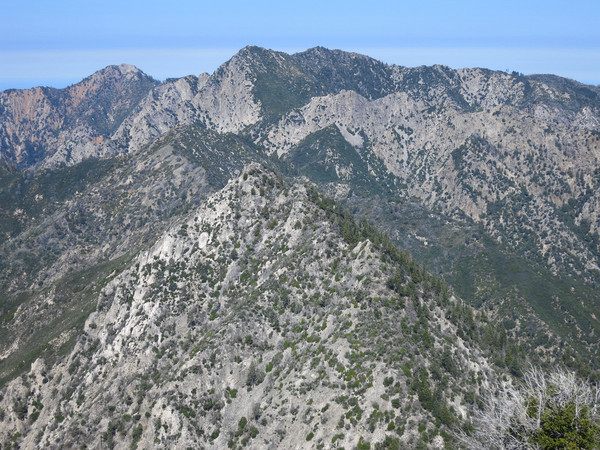
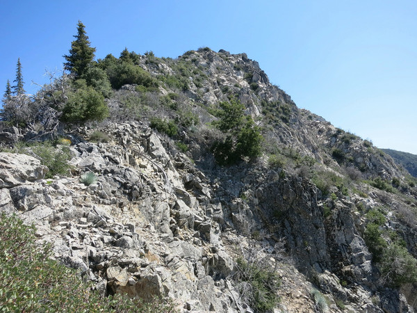
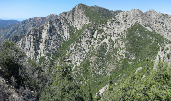 The Intermediary Summits: There are several intermediary summits along the ridge connecting the three Ventana Cones with no official names. Several of these summits are worthy of distinction for their prominence, location and outstanding character. Moreover, passing over these intermediary summits entail some of the most arduous terrain on the route. For reference, I have dubbed Peak 4,455 between Pine Ridge and Ventana Cone as “Blue Peak” since it has a commanding view of the Blue Creek drainage. Peak 4,387, located north of Ventana Cone is arguably the most impressive unnamed summit in the Ventana with steep, cliffy terrain on all sides. In particular, the southwest face of Peak 4,387 is an impressive cliff facade overlooking the Lion Creek drainage. Thus, “Lion Rock” seems like a fitting name for this awesome summit. Peak 4,260+ does not even get a marker on the USGS map, but it’s a prominent summit along the ridge and also overlooking the wild headwaters of the East Fork Ventana Creek. The point is also a milestone on the Triple Crown traverse. When viewed from Ventana Double Cone, Peak 4,260+ has a rounded top characteristic of knobs with a Santa Lucia Fir forest in a scree gully on its north slope. Thus, “Ventana Knob” seems like an appropriate name. Finally, Peak 4,452 is labelled on the map, but there are actually three high points along the narrow ridge separating Ventana Mesa Creek and the unnamed creek draining the north side of Ventana (single) cone. The label on the USGS map is placed on what is the middle high point, but the highest point is actually the southern point (verified by GPS) by a few feet. The northern point along the ridge is considerably lower than its southern neighbors, but is still a prominent point along the ridge. All three high points contain impressive cliff faces, particularly on their southeast sides, with sharp drops on all sides and pointy summits so the “Ventana Spires” is a very apt name to describe these three rugged pinnacles with south, middle and north spires used to identify each of the three high points.

 Preparation: There are several aspects of this route which require planning. First, and perhaps the most critical aspect of this route, is water, or lack thereof. There is no water source from Pine Ridge all the way to past Ventana Double Cone. Essentially the entire off-trail portion of the route does not have water. There is water in the canyons beneath the ridge but the water is several hundred to over a thousand vertical feet below ridge and difficult to access at best. Thus, one must plan to carry sufficient water for several hours of bushwhacking on an exposed ridge or risk dehydration. The first reliable source of water on the trail without a side trip is beneath Puerto Suello Gap. Reliable water can be found near Lone Pine Camp with a short detour. The lack of water on the ridge is closely related to the second important aspect: weather. As the ridge is exposed to direct sunlight most of the way, it is not a good idea to be up there when it is hot or when there is any kind of inclement weather or limitation on visibility. I did the traverse on a relatively cool spring day and I still found it hot in the middle of the day. Attempting the route on a warmer day increases the difficulty proportionately and being on the ridge on a hot day (typical of late spring and summer) would be tortuous and would require substantially more water, amounts that could be prohibitively heavy and cumbersome to carry efficiently through the brush. Third, come prepared for full-on bushwhacking. There is some unavoidable brush and sharp deadfall, particularly between Ventana (single) Cone and Ventana Double Cone, that will shred any exposed skin. It is critical to cover the legs with durable material. You cannot have hesitation charging through the brush and dead vegetation to get through some sections with any kind of decent forward progress. For clarification, decent forward progress can be as little as 1 mph in this brushy, complex terrain. Fourth, understand the topography. The first leg between Pine Ridge and Ventana (single) Cone has fairly gentle topography with light to moderate brush. Most of the time-consuming complexities and arduous terrain is located after Ventana (single) Cone and it persists all the way to Ventana Double Cone. There are several sharp drops between the intermediary summits of Lion Rock, Ventana Knob and the Ventana Spires with incredibly thick brush to avoid and copious sharp deadfall and trees to engage in bushwhacking gymnastics. The terrain is much steeper and contains cliffs with some unavoidable rock scrambling. It definitely pays to study this section carefully and anticipate that the segment between Ventana (single) Cone and Ventana Double Cone will take significantly longer than the segment between South Ventana Cone and Ventana (single) Cone.

 The Route: The route begins at the China Camp TH with the first several miles along the Pine Ridge Trail to Church Creek Divide. This stretch of trail is immensely scenic with excellent views into the Church Creek drainage and also views to Ventana (single) Cone and Ventana Double Cone. From Church Creek Divide, the Pine Ridge Trail traverses a number of drainages as it traverses to Pine Ridge. The most prominent drainage contains the headwaters of the Carmel River and is the last reliable source of water all the way to Lone Pine Spring or the stream below Puerto Suello Gap. It may be tempting to climb South Ventana Cone directly from the Pine Ridge Trail but the upper section is choked with thick brush. Better to save the energy for later. Instead, continue along the Pine Ridge Trail to the junction with the Black Cone Trail and take the Black Cone Trail south to the southwest side of Ventana Double Cone where there is a corridor of light brush to the summit. The SW side requires pushing through a short section of very thick brush beside the trail, but just above the southwest slope is user friendly and becomes less brushy as one ascends. The SW slope is likely the most efficient way to reach South Ventana Cone in present conditions (i.e. no fire in a number of years). After South Ventana Cone retrace steps to the Black Cone/Pine Ridge junction and head toward Pine Ridge on faint use paths. A few majestic ponderosa pines survived the Basin fire and the view from the reddish summit rocks is spectacular. The descent from Pine Ridge is fairly efficient as there are wide swaths of open ground between the bushes. Eventually the open ground becomes lesser and the brush closes in requiring some light to moderate bushwhacking. This bushwhacking continues through the low point between Pine Ridge and Blue Peak but once on the upper part of the ridge to Blue Peak the terrain opens up and the final part is an easy walk on rocks to the summit of Blue Peak.

 From Blue Peak there is more brush to contend with leading to another intermediary summit. I found it best to stay a few feet below the ridge crest on the south side on this section. At the intermediary summit Ventana Cone appears close and the brush becomes lighter for the final stretch to the summit of Ventana Cone. The view from Ventana Cone is stellar and includes all of the remaining highpoints on the way to Ventana Double Cone. From Ventana Cone, descend several hundred feet on the north side of the ridge through Santa Lucia Fir forest and traverse talus slopes and Santa Lucia Firs toward the pass between Ventana Cone and Lion Rock, but stay below the pass. Ascend Lion Rock remaining on the north side of the ridge utilizing more talus in Santa Lucia Firs. Near the top of Lion Rock regain the ridge and ascend the final rocks to the summit. The summit area is surprisingly spacious with some relatively flat rocks. Descending the north side of Lion Rock entail some downclimbing through rocks. The next section was severely burned by the Basin fires leaving a maze of dead trees and branches to navigate. New brush is beginning to sprout through the dead vegetation in spots making forward progress especially taxing. The going is especially tough just after a small pass between Lion Rock Ventana Knob. Eventually, the brush gives way to a pleasant open stretch of grass and yuccas that leads almost all the way to the top of Ventana Knob. Ventana Knob has one of the best views in the Ventana looking across to the rugged South Arete of Ventana Double Cone and the towering Ventana Spires and down the wild East Fork Ventana Creek.
 From Ventana Knob, downclimb some rock and then take a scree gully down through Santa Lucia Firs. Once below cliffs on the skiers right, veer toward Heartbreak Pass, so named because of incredibly thick brush that grows in this low point. Before reaching Heartbreak Pass, traverse west through some brush to a talus gully, which is the ticket to avoiding the thick brush above Heartbreak Pass. Most of the way up the talus gully is a convenient chute that leads to the ridge below the South Ventana Spire. This chute has some fun third class scrambling on solid rock in the lower part which transitions to second class loose talus on the upper part. From the ridge, the summit of South Ventana Spire, the highest spire, is a short third class scramble away. At Ventana Spires most of the complexities of the Triple Crown have already been overcome. It may appear that brush has taken over the entire saddle between the Ventana Spires and Ventana Double Cone, but the thick brush can largely be avoided by staying on the left side near the cliffs that drop into the East Fork Ventana Creek. In fact, this terrain includes some enjoyable scrambling on blocky third class rock. From Ventana Double Cone, it’s all trail back to the China Camp Trailhead, but still many miles fairly of overgrown trails. As of this writing, the Ventana Double Cone trail is overgrown but has seen some substantial work to clear out the brush and blowdowns. The upper mile of the Puerto Suello Trail was cleared of dozens of blowdowns which is incredibly helpful. The middle part is still a challenge with some overgrown parts and blowdowns while the final stretch into Hiding Canyon Camp is in good condition. From Hiding Canyon Camp, cross the Carmel River and head up Hiding Canyon on the Carmel River Trail, which has become quite overgrown through this section. The trail becomes better on the final climb into Pine Valley. It’s a pleasure to come through Pine Valley with its lovely pastures and forest of ponderosa pine. From Pine Valley, it’s up to Church Divide and retracing steps on the Pine Ridge Trail back to China Camp Trailhead.


Thank you for sharing. A great TR on a little used route. The ridge is a classic. Enjoyed reading your other trip reports in that area.
I went out to VDC, then to peak 4387 this past weekend. If you head out there again, you will find the challenging brush has been eradicated. When viewing with powerful binoculars it appeared that all brush was burned off with the exception of the last section between the “ventana spires” and the VDC summit.
Ventana Cone to Pine Ridge did not burn so there will still be some brush on the route. Did you get a special permit to go into the burn scar?