
I don’t often visit the Whitney Zone due its long distance from the Bay Area (7 hours) and convoluted red tape associated with the permitting process. However, I’m always looking for new scenery to explore and parts of this region I have never seen. Snagging some last minute day use permits for the weekend, I came up with a couple good routes to tour the highlights of the region. One route was a point-to-point starting at Whitney Portal to Cottonwood Lakes taking me up the Mountaineer’s route on Whitney, followed by a traverse to Crabtree Pass, through Miter Basin, up the west face of Mount Langley, and finally down Old Army Pass through Cottonwood Lakes. For the second route I hoped to tour Tulainyo Lake with summits of The Cleaver, Mount Carillon, Mount Russell and the north Face of Whitney. The first objective (detailed in this blog post) went off without a hitch, but the second route was stymied by some ice and snow on the exposed class 3 section on Mount Russell’s east ridge. Turning around was a relatively easy personal decision as very exposed third class scrambling on slippery rock is out of my comfort zone with no technical gear. No doubt I will be back to finish off the second route, but I accomplished my primary goals of visiting the astoundingly beautiful Tulainyo Lake area (photos and more details in the next blog post) and the spectacular region between Whitney and Langley. Strava route here.


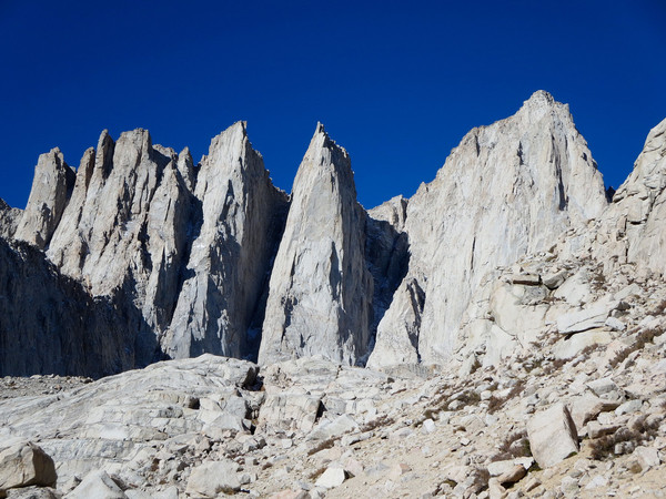
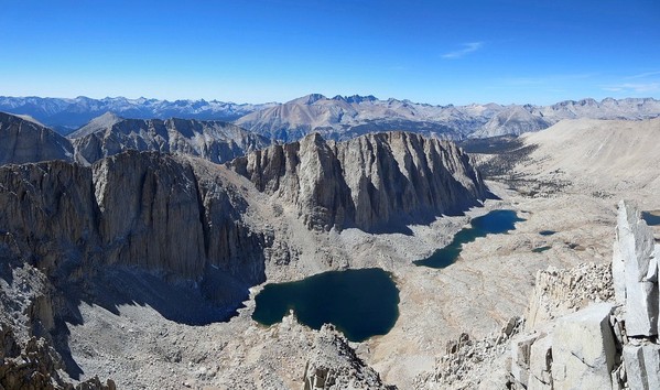
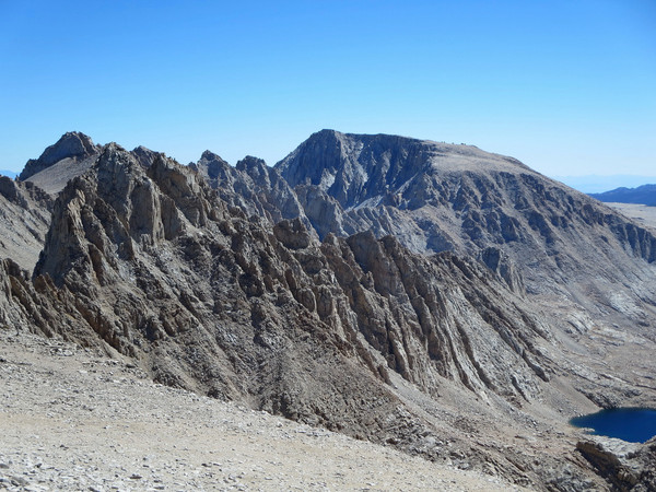
 Driving from the Bay Area on Friday night with a short rest outside of Mammoth Lakes left me with little sleep on Saturday morning, but I was pumped and ready to go up Mount Whitney’s Mountaineer’s route departing the Portal just after 8:15 a.m. The N. Fork Lone Pine has largely become a trail, but since this was my first time up the drainage I managed to stray off the best use-path a couple times. Route knowledge will surely allow for a faster ascent next time. As I ascended above Upper Boy Scout Lake, I was particularly inspired and impressed by the massive pillars of the Whitney massif, especially Keeler Needle and Crooks Peak. I passed by Iceberg Lake and continued up rocks on the left side of the chute which merged with the primary chute where the rock became much more loose and tedious. I encountered some snow along the way that I carefully avoided. Once at the top of the Mountaineer’s I traversed across the north face to the summit plateau since the class 3 rock directly above looked slippery with snow and ice. I was at the summit 2h50m after starting; not bad for my first time with lots of photography stops. The Mountaineer’s route is definitely a more efficient route than the Whitney Trail. See the above panorama for an annotation of the sweeping view from Whitney’s summit (click image for larger version). From Whitney’s summit, I went down the Whitney Trail/JMT and then tagged Mount Muir. There are a couple class 3 moves to contemplate, but once you know the route it takes a matter of minutes to ascend the pinnacle. Muir is one of the many “blips” on Whitney’s south ridge, but since it has prominence and tops out over 14,000 feet it is included in the select group of “14ers”, the subject of fixation among many mountain enthusiasts. From Mount Muir I went to Trail Crest and then ascended Discovery Pinnacle. While only a couple hundred feet above Trail Crest, Discovery Pinnacle had my favorite view of the day, including an unobstructed view of Hitchcock Lakes, Hitchcock Peak, the Kaweah Range, the Great Western Divide, the Whitney massif and points south. From Discovery Pinnacle I was expecting a straightforward descent into the cirque above upper Crabtree Lake that would deposit me just below Crabtree Pass, but I encountered a cliff band that required some navigation. Looking back at this cliff band from Crabtree Pass, I now know the most efficient route for next time which descends almost all the way to upper Crabtree Lake and then contours back up to Crabtree Pass. Descending from Crabtree Pass I first encountered some small tarns and then Lake 3,697 meters, a rather large alpine lake in a desolate setting of rock and granite. My route from this lake to Sky Blue Lake requires a bit of a circuitous route to get around a granite headwall. I stopped to photograph the small tarns with incredible scenery along the way including The Miter and the serrated ridgeline that composes Mount LeConte and Mount Corocoan. I was soon at the shores of aptly-named Sky Blue Lake with a tremendous view of The Miter, Miter Basin, and surrounding peaks. Travel from Sky Blue Lake into Miter Basin is very easy as the terrain is almost flat and composed of granite slabs and grassy meadows. A clump of southern foxtail pines is particularly picturesque set against the granite cliffs of The Miter, Mount LeConte and Mount Corocan. I had my doubts about the west face of Mount Langley, but committed to a chute that looked like it contained fairly solid rock. Indeed, travel was efficient up to the west ridge. However, once on the west ridge, the trip up Langley became an arduous slog through unstable gravel. Fortunately,the ridge grew more rocky the higher I went. A long walk across the summit plateau brought me to the breezy and cold summit. After snapping a few photos and signing the register I started to head down to Old Army Pass. Along the way I spotted a group of four Sierra Nevada Bighorn Sheep. They stopped to stare at me and then continued on their way across the desolate plateau; a surreal moment as the sun was beginning to set over the Sierra. I continued down through Old Army Pass and the Cottonwood Lakes and pulled out my headlamp for the last few miles to the Cottonwood Lakes Trailhead. I arrived at 7:50 pm and it was already totally dark, a sign that winter is fast approaching. The Whitney to Langley traverse through Crabtree Pass and Miter Basin was an excellent route. I look forward to climbing Mount Pickering and visiting Iridescent Lake next time I do this route.


Leor, I am planning on heading up the mountaineers route this coming week from the portal. I have not quite finalized my return route, I was wondering how you found the temps and snow ( or lack of). Any information would be helpful. Great photos!
Giles