
2012 was a fantastic year of adventure running with a diverse set of outings, each with amazing scenery. The following is a recap of the year’s adventures with some of my favorite photographs.
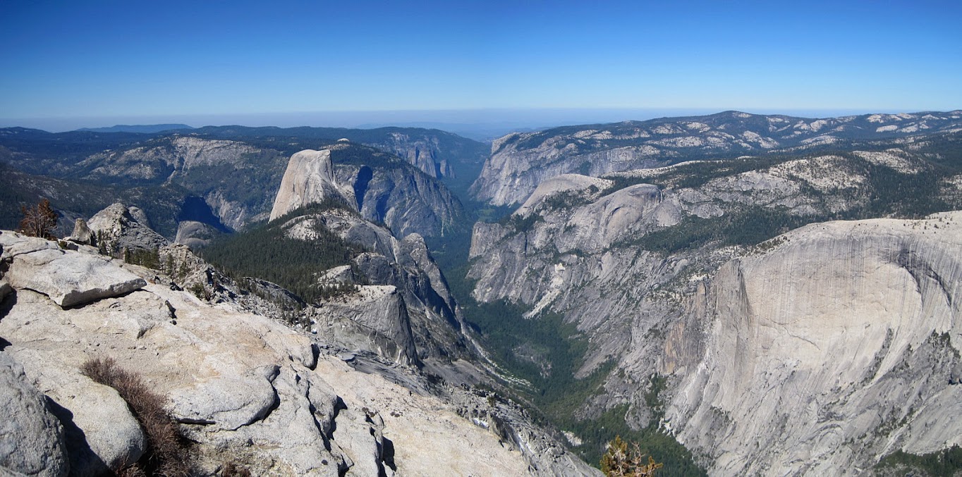
Clouds Rest via Yosemite Valley (May 20, 2012): Clouds Rest is a colossal granite formation with striking prominence. At 9,926 ft, it is not nearly the tallest mountain in Yosemite, but it’s close proximity and unobstructed perch above Yosemite Valley provides spectacular views and a unique vantage of both the high country and the valley. In a 360 degree panorama, one can gaze over to Half Dome, the Clark Range, Tuolumne Meadows. The most impressive feature of Clouds Rest is its northwest face, an immense granite slab polished by glaciers and descending 5,000 ft below to the base of Tenaya Canyon. I have hiked up Clouds Rest previously via Tioga Rd, but this was my first time via Yosemite Valley and it’s a great route and worth the extra efforts. Photos here and here.

Grand Canyon of the Tuolumne (May 28, 2012): The Grand Canyon of the Tuolumne is a rugged, wild and remote corner of Yosemite National Park. I completed this point-to-point adventure in 2010 and couldn’t wait to return this year. In 2010, we did the trip in July, but due to the unusually dry winter season resulting in meager snowpack, the trail was snow-free and we found similar water volume this year in late May as we did in mid-July 2010. Due to the fact that White Wolf campground and lodge were not opened yet, we decided to leave the car at Lukens Lake which added a few extra miles to the trip, bonus over the standard 50k distance (~33 miles total). Complete photo album here.

Emigrant Wilderness 30 Mile Loop (June 3, 2012): The Emigrant Wilderness is located north of Yosemite National Park and accessed via the Sonora Pass Highway. There are several trailheads that access this vast wilderness of glacier polished granite, lakes and meadows. For my first exploration into this region I decided to do a 30 mile loop out of the Crabtree Trailhead above Dodge Ridge/Pinecrest to visit a series of lakes. It’s nice that this trailhead is under three hours from the Bay Area, probably the closest area of the Sierra mountains from the Bay. Each of the lakes on the route deeper into the wilderness became progressively more scenic starting with Camp Lake, Piute Lake, Gem Lake, Jewelry Lake and the highlight of the loop was Upper and Lower Buck Lakes, which featured a great backdrop of granite walls. I also enjoyed Wood Lake as I began my return via Pine Valley. Photos here.


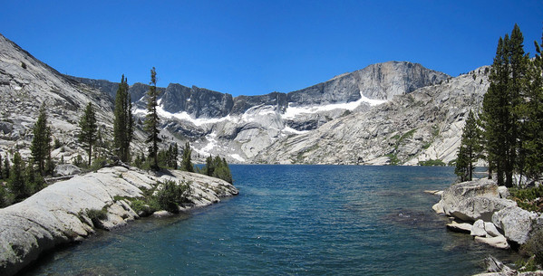
Forsyth Peak & Sister Lakes (June 9, 2012): The Sister Lakes region describes a chain of lakes that straddle the northern border of Yosemite National Park and Hoover Wilderness. The name “Sister” aptly describes the names of these lakes, which include Stella, Harriett, Helen, Ruth, Bonnie, Cora and Dorothy. Forsyth Peak serves as a rugged backdrop for all of these lakes with its permanent snowfields and impressive north face. Dorothy Lake Pass (on the Sierra crest) marks the actual boundary line between Yosemite and Hoover and Dorothy Lake is the only lake that actually lies in the national park (south of the pass) and flows into the Hetch Hetchy drainage and ultimately the Pacific Ocean. The other lakes (north of the pass) drain into the Walker River and the Great Basin. Photos here.


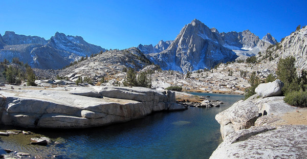
Granite Dome & its lakes (June 10, 2012): Aptly named Granite Dome is an immense granite massif with numerous basins occupied by stunning alpine lakes. All of the lakes are located on the northern side of the massive ridge that culminates in the summit while the south side features much less rock and more meadows. The region is accessed via Kennedy Meadows and features a moderately steep trail to reach Relief Reservoir and beyond, and then off-trail travel along granite slabs to reach a series of lakes including Lewis Lakes (lower, middle, upper), Sardella Lake, Ridge Lake and Iceland Lake. In my opinion Ridge Lake is the centerpiece nestled beneath the towering cliffs of the Granite dome summit. Photos here.


Big Bird & Deadman Canyon (June 17, 2012): The Great Western Divide region of the Southern High Sierra is one of my favorite spots in the entire range. On this day I scoped out a spectacular figure-8 loop out of Wolverton in Sequoia National Park that is mostly off-trail and stays high above the tree line nearly the entire way. The eastern loop of the figure-8 is the more challenging portion with big elevation changes and slab scrambling while the western loop is easy, open cross-country terrain. There was amazing clarity for mid-June with the Central Valley clearly visible over 10,000 feet below.Total time for the ~40 mile route was 13:36 roundtrip. Photos here.

Hyatt Lake Loop (June 24, 2012): Another adventure run into the Emigrant Wilderness, this time a spectacular off-trail loop departing the Pine Valley trail at Louse Canyon and including Hyatt Lake, Big Lake and Pingree Lake (complete photo album here). The stretch between Big Lake and Hyatt Lake was my favorite section with a continuous slab of granite arcing across the entire basin, a stretch that I called the “Granite Highway.”


Lost Coast – King Range (July 7, 2012): The Lost Coast is a spectacular meeting of land and ocean along the most undeveloped, remote and rugged stretch of coastline along the U.S. West Coast. I was eager to return here after an amazing experience in 2010 (see 2010 TRs: King Range, Sinkyone). The northern portion of the Lost Coast is protected by the King Range National Conservation Area and 42,585 acres received Federal Wilderness designation on October 17, 2006. The southern portion is protected in Sinkyone Wilderness State Park, named after the Sinkyone Indians that lived on this part of the coast. The two sections are split by Shelter Cove, a small community of mainly vacation homes, but the parts are completely different in terms of the overall feel and experience. The northern 26 mile section in the King Range NCA from the Mattole River to Black Sands Beach at Shelter Cove is primarily a beach walk with two-thirds of the distance spent on sand, gravel, and rock-hopping and the remaining third on trails just above the beach on the bluffs. The southern 27 mile section from Hidden Valley to Usal Beach in the Sinkyone is entirely on the bluffs above the ocean with arduous climbs and narrow, brushy trails in the forest – a true adventure run with over 7,000 feet of elevation gain. The northern part features sweeping oceanside views at every step while the southern part has inspiring vistas from atop rugged cliffs. Complete album here.


Lost Coast – Sinkyone (July 8, 2012): Part II of the Lost Coast adventure run is from Chamise Mountain to Usal Beach. Due to the remarkably persistent fog, the coastal vistas that I knew existed from the 2010 trip were not visible. Complete album here.

Desolation Six Summits (July 15, 2012): The Desolation Wilderness is the most rugged region near Lake Tahoe with the star attraction being Lake Aloha set amidst the granite slopes of the Crystal Range. Since it’s relatively accessible to Lake Tahoe, it is the most visited wilderness area in the United States per square foot. While there is no shortage of people on the trails on a busy summer weekend, I still found plenty of solitude in this granite playground. This adventure entailed an aesthetic ridge route climbing the six highest summits in the Desolation Wilderness over 11h42m roundtrip out of the Mount Ralston Trailhead. Complete photo album of the six summits loop here.


Ritter-Banner Loop (July 29, 2012): Mount Ritter, Banner Peak and the Minarets are collectively the centerpieces of the Ansel Adams Wilderness. With numerous lovely alpine lakes surrounding these mountains and their close proximity to Mammoth Lakes it is no wonder this region is so popular with hikers and backpackers. It had been since 2007 since I last climbed Ritter and Banner and three years since I was in the Ansel Adams Wilderness (I did a climb of Clyde Minaret in 2009) so it was time to return this past July 29th. I aimed to do an aesthetic loop of the region and tour as many of the spectacular alpine lakes as possible (and take a ton of photos), particularly timing Garnet and Thousand Island Lake in the early morning when I figured (correctly) that lighting would be ideal. Many photos here.


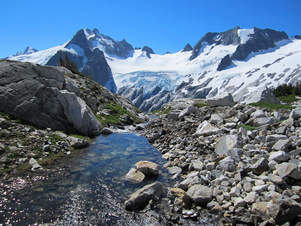
Ptarmigan Traverse FKT (August 16, 2012): Uli Steidl and I completed the Ptarmigan Traverse in 12h17m a new FKT. It has been three years since I last enjoyed the Ptarmigan Traverse so it was time to come back to see some of the most beautiful scenery in the Cascades and refresh the prior FKT. Complete photo album here.


Suiattle Crest 50 Mile (August 20, 2012): I returned to repeat the Suiattle Crest 50 mile adventure run on August 20th. The original run was done on August 4, 2009 in 13h37m. Last week I completed it in 11h44m (1h53m faster). This complete loop, entailing six passes, covers most of the highlights in this region of the Glacier Peak Wilderness including a breathtaking view from Little Giant Pass, a tour through wild Napeequa Valley, 360 vistas from the High Pass area, verdant wildflower meadows, stunning Lyman Lakes, and Spider Gap. It’s quintessential North Cascades scenery – well worth a revisit after three years. Compete photo album here.


Desolation Marathon (August 25, 2012): My second visit to the Desolation Wilderness was in late August for an extremely pleasant loop entirely on trails that hits most of the highlights in the region including great views of Emerald Bay, vistas from Dicks Pass, and gorgeous Lake Aloha. Total mileage according to GPS was just under 26 miles, hence the “Desolation Marathon Loop” name. Complete photo album here.


Cottonwood Lakes (September 1, 2012): An acclimation hike the day before the High Sierra Trail with visit to these lovely lakes beneath Mount Langley.

High Sierra Trail FKT (September 2, 2012): I ran the 72 mile High Sierra Trail from Whitney Portal to Crescent Meadow in 15h46m starting at 3:19 am and finishing at 7:05 pm, a new FKT (previous mark was 18h39m). The High Sierra Trail is a masterpiece of Sequoia National Park traveling from the iconic giant sequoias to the highest point in the lower 48, and passing through some of the most stunning scenery in the Sierra Nevada Mountains en route. It was a great experience in an immensely scenic region of the High Sierra. Complete photo album here.


Parsons Loop (September 8, 2012): I remembered looking at Ireland Lake on the map and thinking it would be a neat spot to visit. I had also viewed the Lewis Creek Basin from Vogelsang Peak and wanted to explore the many alpine lakes I saw in the basin. A high pass separates Ireland Lake from Lewis Creek Basin including some cross country travel and scrambling on the west side of the pass making for a logical loop. We could also ascend to the summit of Parsons Peak about 700 vertical feet above the pass for sweeping views of the Yosemite high country.


Mount Dana (September 22, 2012): An acclimation hike the day before the Evolution Loop with great views of the Yosemite high country.


Evolution Loop (September 23, 2012): The Evolution Loop is a magnificent route through some of the most inspiring terrain in the High Sierra. Technically the route is not a loop as the start and finish are at different locations (more accurately, it’s a horseshoe) utilizing the North Lake and South Lake trailheads (note: the trail and/or road segment that links these two trailheads would not be fun). On ran the “loop” in 12h15m from North Lake to South Lake, which set a standard for speed on the route, starting at 5:01 am and finishing at 5:15 pm. The adventure entails ~55-56 miles and 10,000+ ft elevation gain including three high passes – Piute Pass (11,400 ft), Muir Pass (12,000 ft), and Bishop Pass (11,960 ft). About 25 miles of the route are on the John Muir Trail passing by the famous Muir Hut at Muir Pass. The scenery was stunning as expected, and even enhanced by afternoon cumulus clouds that created shade contrast on the granite. I couldn’t resist spending a fair amount of time on photography on both sides of Muir Pass from Evolution Lake to Helen Lake.The loop was later done in 10.5 hrs so I guess I’m leaving the camera at home next time instead of taking 300 photos. Complete photo album here.


Rae Lakes Loop & Mount Cotter via Sixty Lakes Basin (September 30, 2012): It has been a couple years since I visited the marvelous Rae Lakes region so it was time to return. However, having run the loop straight through twice in the past (deep snow in 2009 and FKT of 7:29:50 in 2010) I thought it was time for something new and Sixty Lakes Basin was intriguing place I’ve been wanting to explore. It also made sense to climb Mount Cotter as part of my explorations in Sixty Lakes Basin. After completing a photography extravaganza in the Sixty Lakes Basin, I decided to finish out the loop and descended towards Woods Creek and Paradise Valley. Complete photo album here.


Sabrina Basin (October 20, 2012): I was last in Sabrina Basin in May 2007 for an overnight peakbagging outing with amazing memories of this strikingly beautiful region. My photo session at Sailor Lake on that trip produced one of my all time favorite mountain scenery photos. It was time to return. I had just enough time to squeeze in a morning run to Hungry Packer Lake and make it back in time for a run to Dusy Basin later that afternoon. On this morning there was some breeze that precluded the type of mirror-like reflection in Sailor Lake that I had witnessed in 2007, but further explorations to Hungry Packer Lake’s outlet yielded some nice shots. I climbed up the ridgelines on both sides of Hungry Packer Lake to gain 360 degree views of the Sabrina Basin. The crisp and clear autumn air produced superlative clarity. A dusting of snow on the north and east facing slopes made it magical. Among my favorite scenes from this outing was a patch of pine snags above the Hungry Packer Lake. The contrast of the reddish orange snags with the deep blue lake and granite was mesmerizing. Complete photo album here.


Dusy Basin (October 20, 2012): While I have made the trek from South Lake to Bishop Pass and into Dusy Basin several times, the magnificent views of the Palisades never cease to inspire. Mount Agassiz, Mount Winchell, and North Palisade collectively form a wall of granite that towers above the basin filled with numerous alpine lakes. Aptly named Isosceles Peak is especially striking from the southern part of the basin and perfectly frames the Palisades “wall.” Columbine Peak and Giraud Peak complete the 360 panorama of rock and ruggedness. On this day, the concept was to do a loop through the upper part of the basin, a “tour de Dusy” and hit some of my favorite photography spots in the process. Complete photo album here.


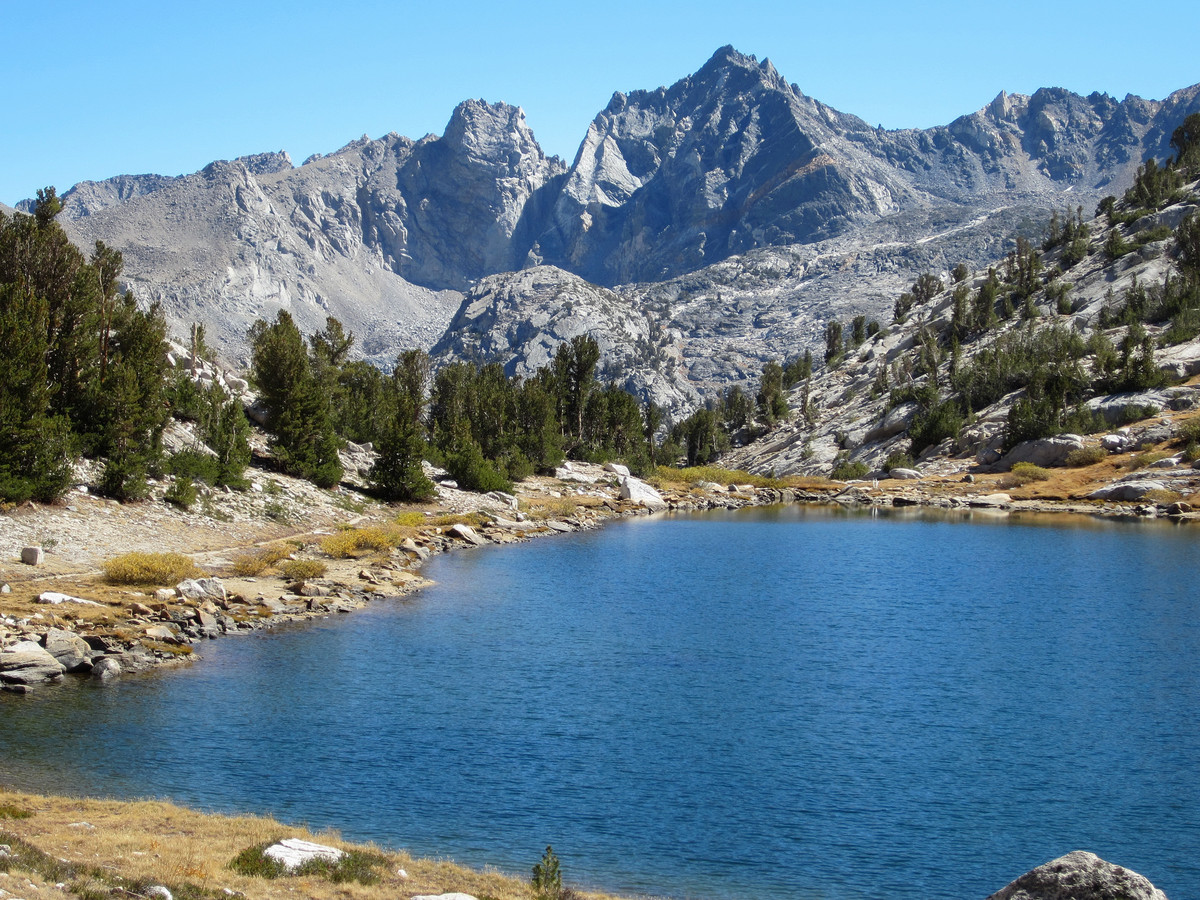
Finger Lake (October 21, 2012): Finger Lake is a Sierra gem beneath the towering walls of Middle Palisade and Norman Clyde Peak. The aptly named lake is flanked by granite cliffs and features a glacial turquoise color emanating glacial remnants above. Complete photo album here.


Kuna & Koip (October 28, 2012): At just over 13,000 feet, Kuna Peak is the third highest point in Yosemite National Park behind Mount Lyell and Mount Dana. The summit provides a spectacular view of the Yosemite high country and Ansel Adams Wilderness including the entire Cathedral Range and Ritter Range. To the south lies Mammoth Mountain and the southern High Sierra while the north features Tuolumne Meadows, the Grand Canyon of the Tuolumne and peaks of Northern Yosemite. The centerpiece of the view is from the rugged peaks of Banner Peak, Mount Ritter and Rodgers Peak to the “Roof of Yosemite” including Mount Lyell and Mount Maclure. The view is not dissimilar from that achieved on Mount Dana, but Kuna is perched much closer to the Cathedral Range and Ritter Range with a direct and unobstructed view into Lyell Canyon. Complete photo album here.


Dinkey Lakes Wilderness & Three Sisters (November 3, 2012): I made a small tour of this Wilderness Area west of the Sierra crest including Cliff Lake, Rock Lake, Second Dinkey Lake and Island Lake. The trails in this region are moderate and very runnable. I also climbed the highest point in the wilderness, Three Sisters, at 10,619 feet.


Hell for Sure & Red Mountain (November 4, 2012): Fall is a beautiful time in the High Sierra and some of my most memorable experiences have come during this season. This year was no exception with many great outings. On my last adventure run in the High Sierra before the peaks became buried in snow, I explored a region of the range I have yet to see (as hard as that might be to believe) – the LeConte Divide. This often overlooked area west of the Sierra Crest features spectacular scenery and numerous opportunities for off-trail exploration. The LeConte Divide is quite rugged belying its lower elevation compared to it’s neighbors to the east. It’s also one of the more remote sections of the range and therefore solitude can easily be achieved. For my first trip to this region, I started out at Courtright Reservoir (which features numerous domes for quality rock climbing) and headed to Red Mountain Basin where I ascended to Hell for Sure Lake, over 15 miles from the trailhead and much of that mileage in the forest. I’m curious what is the origin and etymology of the name “Hell for Sure” since this region is simply stunning – beautiful for sure! I ascended Red Mountain where I marveled at the 360 degree views including the Sierra Crest, Goddard Canyon, the LeConte Divide, and the Sierra foothills. The best view of all, however, was Red Mountain Basin immediately below, with at least seven shimmering lakes tucked beneath Mount Hutton and Hell for Sure Lake being the large centerpiece. Perhaps the prettiest lake in the basin is Horseshoe Lake, situated among polished granite cliffs, clumps of trees and the north face of Mount Hutton towering directly above.


Such a wonderful experience! I visited Sequoia park too and the Kings Canyon National Park accommodation is one of the finest in the area.
So impressive!!! I’m so jealous!