
 Photos here. This post is the third installment of a series on the Ventana Double Cone region, which features arguably the most rugged and wild coastal terrain in the contiguous United States. The first post described a repeat of “The Drain” route with a mini-loop addition to visit the stunning “Ventana Spires” and the second post detailed the Ventana Triple Crown which is a spectacular high ridge traverse from South Ventana Cone to Ventana Cone to Ventana Double Cone including several rocky and remote intermediary summits. This last posts describes a point-to-point route up beautiful Ventana Creek past 50 ft Ventana Falls to La Ventana (aka The Window) and Kandblinder Peak carrying over into the Little Sur drainage to finish at Bottcher’s Gap. This was one of the more rugged adventures I’ve done including Ventana Creek’s beautiful gorges and cascades amid old growth redwoods, the extremely remote and stunning Ventana Falls, an ultra-steep climb up to the namesake geographical feature of the Ventana Wilderness (La Ventana aka The Window), and spectacular views from Kandlbinder. From Ventana Camp to Jackson Camp it was an arduous but rewarding adventure over terrain that is grand, awe-inspiring and humbling at the same time – the heart of the Ventana. Full album here. GPS route here.
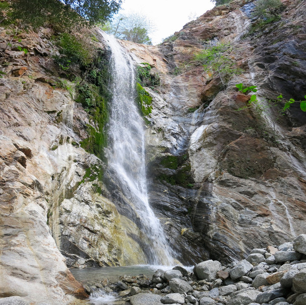
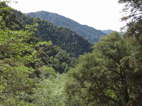
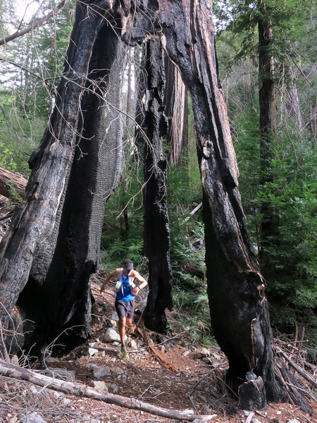
 The route begins at Big Sur Station with some trail miles on the Pine Ridge Trail above the Big Sur River gorge. After 4 miles on the Pine Ridge Trail descend to Ventana Camp along the Big Sur River. Follow the Big Sur River downstream a short distance and then take a use path to the entrance of Ventana Creek. Ventana Creek is an amazing creek walk including narrow gorges with small waterfalls and rapids in a setting of lush redwoods, ferns and moss. The creek wading is often not optional since the walls of the canyon periodically come right down to the water course. Walking up Ventana Creek there is a strong sense of remoteness as few have traveled up this unspoiled waterway. Ventana Creek is not an advisable place to be in higher volume creek flow and there is ample evidence of the power of the water that comes down this canyon during winter storms. It’s fairly slow going wading in the creek with innumerable step overs, immense redwood log jams, clear pools, small waterfalls and other obstacles to climb through, up and under. However, as creek walks go Ventana Creek is fairly efficient. Near the confluence with the East Fork Ventana Creek the forest canopy parts for a moment providing glimpses of the cliffs and rocky buttresses of Ventana Double Cone, the Queen of the Ventana, presiding over a rugged region that is unmatched in the coastal mountain ranges of the west coast of the United States. After about 5.5 miles of creek walking in Ventana Creek, one gets a sense of the canyon walls closing in with a headwall approaching. First there is a thin falls coming coming in from the right on a tributary flowing off Kandlbinder. Then, a few feet later one rounds a corner and is treated to Ventana Falls, which tumbles an estimated 50 feet over reddish and white cliffs into a nearly circular amphitheater. Evidence of rocks and vegetation strewn about the base of the falls indicates it is very flashy during periods of heavy rains, but since it’s very close to the headwaters it appears flow returns to relatively light shortly thereafter. Ventana Falls is not particularly high and it does not maintain high volume, but it’s extremely remote setting in a reddish amphitheater of cliffs is stunning.


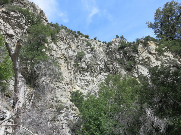
 Getting around Ventana Falls to access the terrain upstream is perhaps the crux of the route. A few feet downstream of the falls is a loose gully in an active rock slide zone. There appears to be two options to get around the falls from here. The first option is to ascend the gully a short distance and find a way to climb a short vertical step of reddish rock. This rock is crumbly so extreme care must be taken. The second option is to ascend the gully about 100 vertical feet. About midway up the gully the loose rock is interspersed with solid bedrock. Carefully ascend the rock and look for a non-technical traverse that can be taken to exit the gully and access easier terrain that leads back down to Ventana Creek above the falls. Regardless of which route is chosen, the rock is extremely loose so caution must be taken with each move. Above the falls, the creek is characterized by a lot of large talus blocks which provide an efficient means of travel and gaining elevation as the grade becomes steeper. The creek disappears at times under talus so make sure to fill up water while it’s still easy to access.
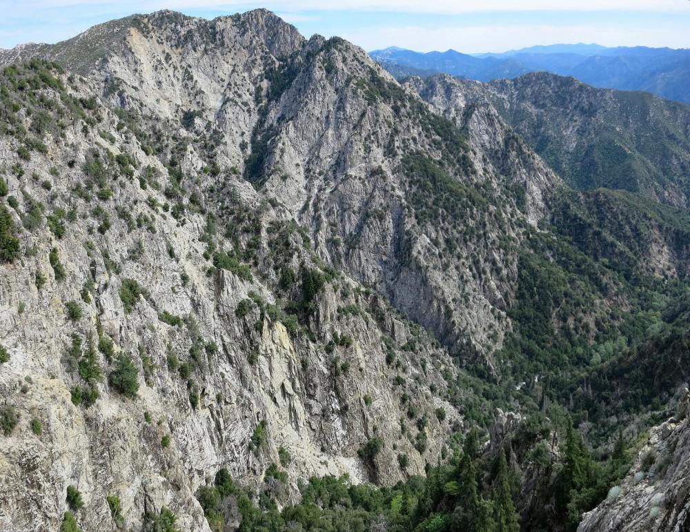
 At a broad, open section of talus, the main drainage curves into the Drain which flows up toward Ventana Double Cone, but to access the Window take a smaller gully to the left. This gully ultimately leads toward Kandlbinder, so one must be on the lookout for shallow gullies that trend up and right toward the Window. It seems there are several shallow gullies at the bottom but the correct one ascends toward the vertical cliff band that descends off the east side of La Ventana. I found the most solid talus to be immediately beneath these cliffs on the right side of the gully. The route up to La Ventana is a straightforward, albeit steep talus climb with no technicalities encountered. While the views from the Window proper are mostly obscured by the vegetation, there are excellent vistas of Ventana Double Cone and the Ventana Creek drainage on the way up. Immediately above La Ventana is a pinnacle that forms the western high point of the window frame. This pinnacle has arguably the best view of the Ventana Double Cone region. At your feet is a sweeping vista of the rugged cliffs and buttresses above the east side of the Window stretching down into the Drain and the western face of Ventana Double Cone. It’s an awe-inspiring panorama that is unmatched in the Ventana in terms of the sheer ruggedness.
 From The Window or its western pinnacle it may be tempting to stay on the ridge crest which contains plentiful deadfall and brush. While this route on top of the ridge is feasible, it is definitely easier and likely faster to traverse on the north side of the ridge utilizing open terrain amid Santa Lucia Fir and talus. After some traversing a talus gully leads back toward the ridge crest where the final climb along the ridge to Kandlbinder is on open terrain with excellent views looking back to Ventana Double Cone. Kandlbinder is an awesome spot to soak in the 360 degree views including the entire Little Sur River drainage with Pico Blanco, Post Summit and Cabezo Prieto, Ventana Double Cone and the Drain, the Big Sur River drainage and distant views all the way to Cone Peak and Junipero Serra. The descent off Kandlbinder is a bit arduous on loose talus and scree fields, but one can find some plunge stepping lanes on the edges of the main rock gully. From the bottom of Kandlbinder’s gully, walk down the drainage (the headwaters of the LIttle Sur River) until a very small climb leads up and over a saddle into the Jackson Creek drainage. At this point a use path becomes more defined and as one descends into Jackson Creek it’s important to stay on this use path which is fairly efficient in its upper portion. As the use path descends further into the Jackson Creek drainge there is increasing deadfall to negotiate but the general idea is stay near the creek alternating sides to utilize the path of least resistance. While going down Jackson Creek is certainly easier than going up, it’s not a great deal amount faster due to all of the blowdowns. Near the bottom of Jackson Creek is pretty Firehose Falls with a small but beautiful pool. The confluence with the Little Sur River is just beyond. While there are several crossings of the Little Sur River, the trail becomes much easier to Jackson Camp and on to Pico Blanco Boyscout Camp and finally the dirt road up to Bottcher’s Gap.


You guys are nuts, but don’t stop. I will be exploring that area in a few years.
Great photos and nice TR. The ‘window” is a great trip, nice to see it is as beautiful as I remember it.