

It’s late April and the window for snow on Cone Peak (aka a “Snow Cone“) has all but closed. Winter (finally) came to California this year with an intense 6 week period of storms lasting from early February through mid March. The result is quite a bit of Snow Cone to talk about this season. However, half way through January it wasn’t certain we would receive any snow. With strong high pressure in the forecast some very smart meteorologists and climate scientists had declared winter in California all but over predicting that the high pressure would become entrenched with weeks of dry and warm. These predictions were not unfounded. Model data was showing the polar vortex heading to eastern North America which typically produces persistent high pressure ridging in western North America. The long range models were almost all pointing to warm and dry in an all-too-familiar pattern reminiscent of the drought years. Most Februaries in recent memory had not delivered anything resembling winter weather to California. At this point the spectre of another drought year loomed large.
Fortunately, nature had other ideas. What followed was basically the opposite of those predictions. Persistent low pressure troughing developed in the Pacific Northwest and a series of cold storms ensued throughout the month, some of which tapped into modified arctic air from Western Canada and the Gulf of Alaska. These cold storms had been conspicuously absent over the past seven years and were a welcome sight. The storms produced prodigious snowfall in the Sierra and a series of memorable snow events for the coastal mountains of California including the Diablo Range and the northern Santa Lucia Mountains, including Cone Peak on the Big Sur coast. I was fortunate to visit Cone Peak for five “Snow Cones” this season during four separate storm sequences. Three of the Snow Cones were moderate size and two were major Snow Cone events. According to my personal scale, 2-4 inches is small event, 4-8 inches is medium, and 8+ inches is a major Snow Cone event (anything less than 2 inches is a non-Snow Cone event). Four of the Snow Cones were in February and one was in March. Here is a summary of the Snow Cones and key takeaways from the season farther below.


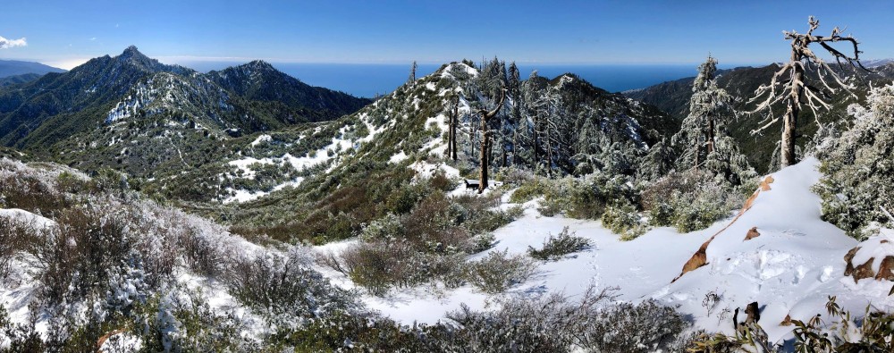
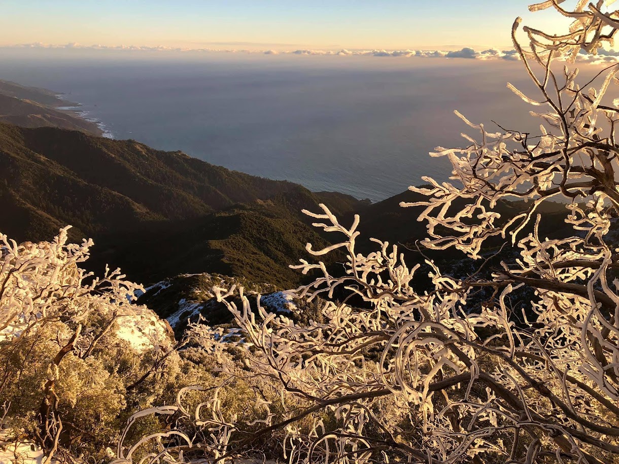
February 5th: The first snow (always the hardest!) resulted at the conclusion of a three part storm which started with a tightly wound up mid-latitude storm, then a cold front from the Gulf of Alaska, and finally a modified arctic front descending from British Columbia ushering in some very chilly air. The final part of the storm burst open the snow season for coastal peaks and resulted in the lowest snow levels observed in years in the SF Bay Area with snow reported near sea level and accumulating snow below 2,000 feet in spots. The cold air pool and best moisture with this first storm was generally north of Big Sur. Cone Peak had accumulating snow (>1 inch) down to just below 3,000 feet and the summit had around 8 inches of accumulation, which is a high end medium size snowfall for Cone. Toward Tin Can Camp and Cook Springs the snow depth was closer to a foot so if I were more generous this could be classified as a major event. What this event lacked in moisture it made up with wind and cold temperatures as a tremendous amount of rime ice accumulated on all of the vegetation along the ridges. The strong winds also blew off most of the snow from the vegetation leaving only the ice. Fortunately, the ice was so thick that the winter wonderland effect was still strong along the ridges. Very cold air swept in after the system exited and kept temperatures locked in well below freezing all day. When the clouds parted in the afternoon I was ready to capture the icy wonderland during evening light and sunset. February 5th photo album here.


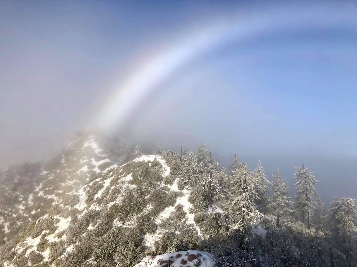
February 9th: Another multi-part system from the Gulf of Alaska tapped into modified arctic air from British Columbia and brought renewed cold rainfall and hail to the lowlands, and snow to the coastal mountains of Big Sur. This storm took a similar track to the first storm resulting in a similar overall pattern, but additional waves of moisture produced higher snow totals. On this day there was about 8 inches of new snow on the summit and areas that failed to melt in the intervening days after the February 5th event were now well over a foot. The most memorable part of this storm was in the early morning which featured a parting of clouds revealing a well defined fog bow, and a wonderful view of the Pacific Ocean complemented by some cumulus clouds. Those cumulus clouds would then enshroud the mountain for most of the day before briefly parting in advance of the next wave of the storm sequence. This storm was not as cold as the first and temperatures rose above freezing in the afternoon resulting in a melt-off of south facing slopes but north, shaded slopes held onto the snow all day with little to no melt. The snow line was a bit higher at about 3,200 ft with substantive snow (>1 inch) relegated to about 3,500 feet and above. This storm was also windy preventing much snow from accumulating on the trees and chaparral. In summary, this was another high end medium sized event. February 9th photo album here.


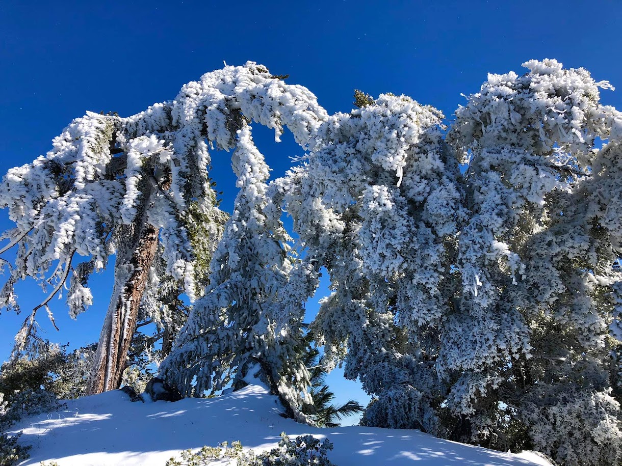
February 10th: Another wave in the second sequence passed through overnight depositing an additional 8 -10 inches on the summit. The actual amount of new snow was difficult to measure due the underlying snow from previous storms. By now snow depths on the summit were becoming deep and measured at 16 inches. On favored aspects of the north ridge snow depths were well over 2 feet as drifting snow was piling up and even creating mini cornices. Rime ice on the vegetation near the summit and along the north ridge was truly spectacular as Santa Lucia Firs were entirely cloaked in several inches of ice. The snow line was once again about 3,200 feet and snow amounts really only became substantial above 3,800 feet with an exponential increase between 4k and 5k. Similar to the February 5th event, the mountain was mostly cloudy in the morning but a marvelous breakout occured in the afternoon into sunset. Temperatures stayed cold throughout the day (below freezing), but perhaps not quite as cold as the February 5th event. This Snow Cone easily marked the deepest snow of the season and also the thickest rime ice I have ever observed on the mountain and qualified as a major Snow Cone event. February 10th photo album here.


February 18th (President’s Day): A tropical airmass invaded California during the week after the February 10th event and several inches of rain washed away most of the snowpack. If it were not for this atmospheric river the snowpack would have been ridiculous, but for the most part we were starting from scratch on most of the terrain. The atmospheric river was short lived and another cold storm out of the Gulf of Alaska descended over California with renewed snow on the peaks above 3,000 feet in Big Sur. Snow amounts on the summit were around 8-10 inches with over a foot to the north at Tin Can and Cook Spring vicinity, qualifying as another major Snow Cone event. After the storm’s departure it stayed clear and cold on the 18th with spectacular wintry views across the snowy landscape to the Pacific Ocean. February 18th photo album here; panoramas album.


March 10th: After a few week hiatus in which most of the snow melted, nature provided one more Snow Cone. This was a moderate sized event with ~6 inches at the summit. Unlike the past events, it was much less windy during this storm so more snow accumulated on the trees resulting in more of a snowy winter wonderland effect on the vegetation. Spectacular early morning views gave way to rising temperatures and rapid cumulus development in the late morning and afternoon. When things became slushy and foggy I knew there was a chance that the Snow Cones for the season were coming to an end. March 10th photo album here.


Takeaways:
- Big February: Total accumulation for the season on Cone Peak was around 40 inches, most of which fell in February. This makes February one of the snowiest months in the Santa Lucia Mountains in recent memory. However, the greatest summit snow depth I observed was only 16 inches so a good deal of the snow melted between the storm sequences and the snow depth did not reach full potential considering the high seasonal total. However, on the north ridge snow drifts reached over 2 feet deep with cornices forming along the ridge so it was still impressively deep. At times this corner of the Ventana Wilderness looked more like the Sierra Nevada than merely 3 miles from the Pacific Ocean. Moreover, coverage and depth (especially drifts) near the summit was easily the deepest I have personally seen on Cone Peak. For a day or two some of the chutes were probably skiable! In retrospect, California (finally) had a real winter for about 6 weeks. After mid-March winter gradually relinquished its grip, and as of this writing April is actually well below average in precipitation.
- Wind & Rime: The storms in February were all extremely windy so snow had a difficult time staying on the vegetation. This reduced the winter wonderland effect somewhat, but that was partially made up by the tremendous amount of rime icing that occured with these windy storms. The ferocious winds drove clouds over the ridges at high speeds and the water vapor in the clouds froze to the vegetation which was below freezing. After many hours of this process the rime ice had accumulated several inches thick to the point some of the firs and pines were barely recognizable.
- The Sweet Spot: Cone Peak was consistently south of the “sweet spot” where the cold pool and moisture combined to produce lower snow levels. Therefore, the snow line was not as low as points farther north in the SF Bay Area. If the trajectory had been more favorable for the Central Coast snow levels could have easily lowered to 2,500 ft or even below 2,000 feet as in 2011. The lowest observed accumulating snow (>1 inch) was with the first storm when the snow line came down to ~2,800 feet. After the first storm the snow line was generally above 3k, and a 3k snow line is not particularly remarkable for a Snow Cone. However, snow amounts increased rapidly as one ascended, especially between 4k to 5k resulting in the impressive seasonal totals on the summit.
- The Gold Standard: While February 10th had the deepest snow I have seen, especially in the drifts on the north ridge, the 2017 Snow Cone still remains the gold standard for overall best snow cone event. In 2017 the snow line (>1 inch) was down below 2,500 feet and the winter wonderland effect was at its best as less wind allowed the snow to pile up on the trees and chaparral well down into the depths of Devils Canyon. Snow amounts then were measured at 15 inches on the summit so only marginally less than February 10th, but it looked like more with the snow piled up on all of the vegetation and the snowline lower down the mountain.
- Cold Evenings: This season’s events were the coldest I have experienced. In all of my prior Snow Cones, the temperatures rose above freezing at some point in the afternoon; it was not a question of if but when. However, on two occasions this season temperatures stayed below freezing all day and therefore the tremendous rime icing that occured with these storms was locked in with no melting. This enabled special opportunities to experience evening light and sunset while everything was still completely frozen. Above all else, I think these cold evenings were the highlight of the season for me. Standing in a frozen, snowy landscape with the turquoise waters of the Pacific Ocean below while catching the soft evening rays of sunlight is an experience I won’t soon forget.
- Multiple Factors: Many factors besides depth of snow at the summit determine the overall beauty of a Snow Cone. A major factor that is often present is rime ice. A heavy rime ice accumulation can make a magical experience on the ridges even if the snow pack is relatively thin. Conversely, if it is very windy the snow is blown off the vegetation. Since most of the ground is covered by dense chaparral a windy event will generally yield a much less wonderland-y outcome than a smaller accumulation during a relatively calm snowfall that was able to stick and accumulate onto the vegetation. Temperature is also critical. A cold airmass after the snowfall can keep the ice and snow locked in for longer, and as shown this year, when that lasts into sunset it’s magical. Finally, the snow line is key as the difference in the amount of land surface area covered between a 2.5k snow line and a 3.5k snow line is huge. The wonderland effect is at it’s best when the snow line reaches well down Stone Ridge and into Devils Canyon. While all of the events in 2018 were small, they possessed some of these other factors that made them memorable. As mentioned above, the 2017 Snow Cone continues to be the gold standard for combining all of these factors.


Fabulous explanations and pictures, I trust no other winter on Snow Cones has been as well as documented those! And I can’t imagine the number of hours you spent up there to capture all this. Thank you for sharing!
Thanks! I spent about 50 hours up there total, but many times that following the weather models in anticipation!