
Photos here.
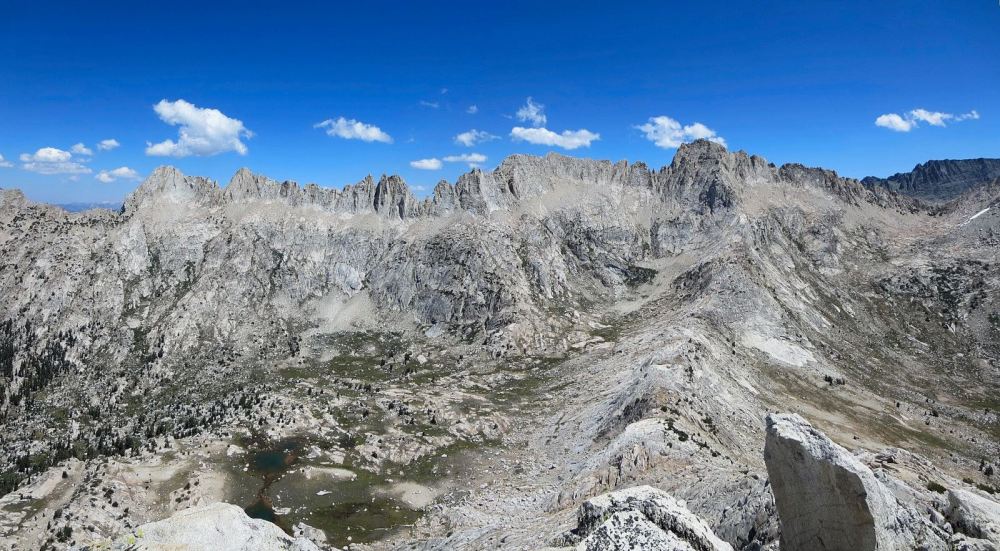
The “Sawtooth Loop” is a spectacular route through one of the most scenic regions of the High Sierra and a personal favorite. I call this particular route the Sawtooth Loop since it circumnavigates an impressively rugged subrange of the Sierra crest known as Sawtooth Ridge that straddles Yosemite national park’s northern boundary and the Hoover Wilderness. This deeply serrated ridge resembles a sawblade and contains features with enchanting names like Three Teeth, The Doodad, Dragtooth and Sawblade. On my route I chose to climb Matterhorn Peak, Finger Peaks and Kettle Peak, but there are numerous other variations and objectives in the region to include on such a loop, including the aforementioned points along Sawtooth Ridge, Eocene Peak, Crown Point and Slide Mountain. The north side of Sawtooth Ridge is conveniently close to Twin Lakes and Mono Village, even allowing for straightforward access during the winter months. This area has numerous popular destinations like Barney Lake and Peeler Lake for hikers and the world famous Incredible Hulk for climbers. However, the south side of Sawtooth Ridge, located in northern Yosemite, feels remote and wild with comparatively a small fraction of the visitors. Matterhorn Canyon and Slide Canyon are spectacular glacier carved canyons lined with smooth granite walls and lovely meadows. A carry-over Matterhorn Peak, the highest point on the ridge, is an excellent way to access the outstanding scenery and wilderness of this region south of Sawtooth Ridge. Strava route here.


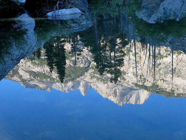
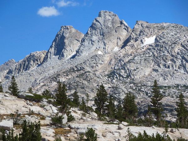
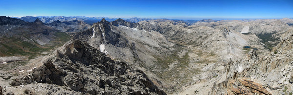
The most straightforward ascent of Matterhorn is via Horse Creek Pass. The going is very reasonable up to a shoulder above Horse Creek Pass, but once around the corner there is a section of tedious gravel slopes on Matterhorn’s southeast slopes (two steps up, slide a step back). The east couloir route, which I did on my first trip ever in the Sierra, is the preferred early season route when the couloir is still snow covered. Right now it looks like a loose, steep mess for a taxing ascent (i.e. more tedious than the Horse Creek Pass route). After enjoying the view from the summit I scrambled down to a small col where a sandy chute provides access to Matterhorn Peak’s southwest slope and Matterhorn Canyon. The descent through the chute is loose and also much preferable as a descent route. The chute deposited me fairly rapidly into the headwaters of Matterhorn Canyon. From upper Matterhorn Canyon I traversed over to Finger Peaks and scrambled up the east Finger. I wound up in hard class 3 and class 4 but it probably could have been easier if I was more careful with my route selection. I traversed the south side of the middle Finger and then ascended it via the class three route (starting from the notch between Middle and West Fingers) to gain summit and the highest point of Finger Peaks. This class 3 route seems improbably with a narrow natural ledge cut into a steep and smooth granite face piecing together two class 3 scramble portions. Without this ledge, the scramble looks like it would be at least class 4. The view of Sawtooth Ridge, Matterhorn Canyon and Slide Canyon from both the east and middle Fingers are stupendous – one of best panoramas I have seen in the Sierra. I was happy to see the couloir west of the middle Finger was largely snow free so I descended more steep and loose slopes (carefully skirting around ice) and then pleasant alpine meadows down to the Burro Pass Trail. After a couple miles of running along the Burro Pass Trail, I headed cross country through meadows and granite benches to Ice Lakes Pass where I continued up to Kettle Peak. I had initially thought about tagging Eocene, but the route looked to require a bit more time than I had on this day. Kettle Peak was an awesome replacement objective with arguably the best view of the Incredible Hulk rock wall. From the summit, it’s as if you’re in a helicopter staring down at the sheer rock with climbers that look like specs on the immense granite face. Descending from Kettle Peak the views of the Incredible Hulk and Maltby Lake continued. I passed by some climber camps and then picked up the good use path through Little Slide Canyon. It’s an arduous climbers path to be sure, but it would be an incomparably more arduous trek through Little Slide Canyon without this path. The Incredible Hulk is all that I imagined it to be and more – a precipitous rock spire rising nearly vertically from the talus slopes below. It’s quite awe-inspiring to stand beneath this rock, especially in the afternoon with ideal lighting. It goes without saying that I’ll be back for more adventures to this wild and remote corner of northern Yosemite. Strava route here.


Dolomite California !
Great photos! I’ve been up Matterhorn twice via Horse Creek Canyon, but it is not so easy anymore, having moved to Denmark in 1991. Keep them coming, you’ve got me hooked!
What time of summer was this trip?