
Photo album here.
Tulainyo Lake sits in a desolate bowl 12,828 feet above sea level nestled between four peaks – Mount Russell, Mount Carillon, Tunnabora Peak and The Cleaver. It is one of the highest lakes in the contiguous United States and impressively large for its altitude. Due to its elevation and shadowing effects from nearby peaks, the lake often remains ice and snow covered well into the summer. In late summer and fall, with the ice and snow melted, the lake reveals a cerulean color with turquoise along its shores. The photogenic setting is stark with the lake’s pure waters set amid granite boulders and cliffs. I have wanted to visit this lake for some time and it did not disappoint.

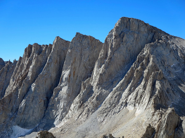
 I accessed Tulainyo Lake via Cleaver Col. I took the North Fork Lone Pine trail to Lower Boy Scout Creek and then headed uphill on easy cross country slopes. As I ascended into the cirque below Cleaver Col, The Cleaver’s immense south face of smooth granite came into view. This amphitheater of rugged granite walls is spectacular. I found the route to Cleaver Col straightforward except for some loose rock and snow in the final chute. After a little over a couple hours I was at Cleaver Col peering over at the broad expanse of Tulainyo lake. While warming nicely on the eastside of the crest, I found a sharp and cold wind blowing over the col and I quickly put on my jacket. It would stay cold and breezy most of the morning, especially in the shade. I descended almost down to the lake shore before heading up to The Cleaver. The Cleaver is mainly a boulder hop except some class three near the top. The summit provides a breathtaking view of Tulainyo Lake framed by Mount Carillon, Mount Whitney and Mount Russell. Coming off The Cleaver I traversed Tulainyo’s east shore and ascended up to Russell-Carillon saddle. From here I made the short hike up to Mount Carillon with its outstanding view of the east ridge of Mount Russell. Back at Russell-Carillon saddle I started my way up Mount Russell’s east ridge. While this route is called the east ridge, it is not possible to stay on the ridge proper without technical climbing and one must drop onto the north side. This shaded north side held new snow and ice from a storm a few days prior. After carefully scrambling through the slippery snow along most of the ridge I got to a point where I did not feel comfortable continuing in the current conditions and I returned back to Russell-Carillon saddle. On the way back to Whitney Portal I stopped at beautiful Upper Boy Scout Lake and then returned down the North Fork Lone Pine Creek. While I did not complete Russell, I achieved my goal of exploring the Tulainyo Lake basin. I will definitely be back to this area to complete my intended route, which includes completing the East Ridge of Russell, an ascent of the North Face of Mount Whitney, and finishing off with a run down the Whitney Trail.


Breathtaking.
What date in October did you climb Carillon?
Awesome views! Thanks for sharing!
Incredible photos. What a fantastic trip and report. This lake has been on my list for years, too… there’s nothing else like it.
Thank you so much for sharing this. It is something I would have done when I was younger. The photos are spectacular.
Just stumbled upon this post. I did a linkup of Russel and Carrilon last summer. Thanks for bringing back some fun memories!