

Arroyo Seco means “Dry Stream” in English but the Arroyo Seco River is anything but dry after winter storms when 1,000+ cubic feet of water per second regularly flow down the winding, narrow canyon. In fact, the Arroyo Seco River drains the east side of some of the wettest ridges in the Santa Lucia Mountain Range. This immense flow of water through a tight space has sculpted a series of magnificent gorges and pools. The “Complete Arroyo Seco” is arguably the best creek walking adventure in the Ventana Wilderness passing through all of the premier highlights on the river. It starts near Escondido Campground and goes all the way down the river to the Arroyo Seco Gorge Day Use Area where the river effectively exits the canyon. One can shorten the route by exiting at the Marble Peak Trail bridge (skipping two highlights in the Keyhole and Rocky Creek Falls and many pools and cascades) or extend the route by getting into the river upstream of Escondido at Memorial Park (which will add a few additional pools, most notably the Escondido Pool). However, for a day trip, the route as described from Escondido to the Day Use Area is the most logical and allows the most time for the slower portions where swimming is required. The full loop runs about 28 miles with about half in the Arroyo Seco River canyon. The route is basically only available during the summer when the river slows to <25 cfs and the narrow gorges become safe to explore. Moreover, the water temperature can be quite cold until midsummer when the hot summer days characteristic of this region have sufficiently warmed up the water temperatures. As such, it may be prudent to wear a wetsuit in early summer. By midsummer the water is usually warm enough for swimming without a wetsuit, especially if it’s a hot summer day typical of this canyon, but even then one may find a wetsuit jacket or spring suit helpful as considerable time is spent in the water. By late summer and early fall, the river may slow to the point that the pools are somewhat stagnant and unappealing, especially in the upper part, and features like Eagle Creek Falls may be a trickle. Thus, the ideal time is usually between June and August.


At essence, the route description is simple: follow the river downstream. From the trailhead at the end of the paved road in the Arroyo Seco area (the “Upper Gorge” Parking), take the Indians Road for roughly 13 miles to Escondido Campground. The road is closed to vehicular traffic and is a highly scenic trip in its own right with excellent views of the Arroyo Seco canyon below and interior Ventana Wilderness. The road ascends to a high point of ~2,800 feet before descending to Escondido Campground. Hanging Valley, just after the highpoint, can serve as a nice place to camp if doing the route as a backpack. At Escondido Campground, descend through the campground to find the Lost Valley Trailhead which descends to the Arroyo Seco River. At the river, simply begin heading downstream.


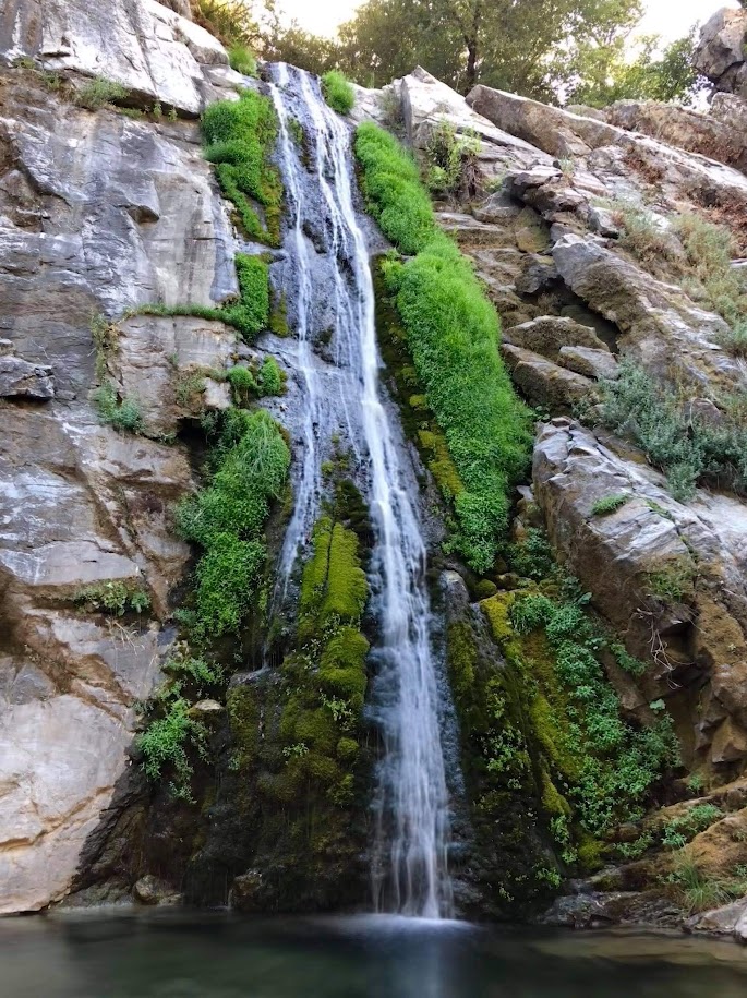
The first part of the trek downstream is mostly benign with rock hopping and occasional crossings of the river (more like a creek during the summer at this elevation). A large boulder section is encountered with some easy scrambling on the left. The river has some shallow pools through this section that can be avoided if one wants to keep from swimming so soon (hint: swimming is required downstream). This upper section is heavily wooded and includes a sprinkling of incense cedar and Santa Lucia Firs. The first highlight of the route is Eagle Creek Falls which is a beautiful tall falls on a tributary that is very close to the Arroyo Seco River. The falls includes a pretty plunge pool surrounded by grasses and old sycamores. This upper part of the route can be quite buggy so be prepared for face flies!


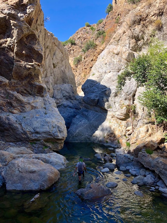
Downstream of Eagle Creek Falls the river includes additional shallow pools and plenty more rock hopping. At the confluence with Lost Valley Creek, flow in the river increases substantially, and consequently the pools become deeper and more polished. Efficient travel varies on either side of the river as obstacles present themselves. There are also increasing situations where simply wading/swimming in the river is the most efficient path downstream. If you have gear which you intend to keep dry, bring a dry bag, or it will get wet! After several miles of creekwalking one reaches another highlight of the route known as the Yin Yang Pools. At first the river enters a nice polished section over bedrock with small cascades before culminating at a pair of large pools with cavernous cliffs. Located in the most remote corner of the Arroyo Seco River, the Yin Yang Pools are shaped like the Yin and Yang symbol with the two large pools connected by a small waterfall. The larger lower pool is very deep and the polished rock manifests the power with which the river flows through the canyon after winter storms. The wonderful pools combined with the wilderness character make this is a spectacular spot.


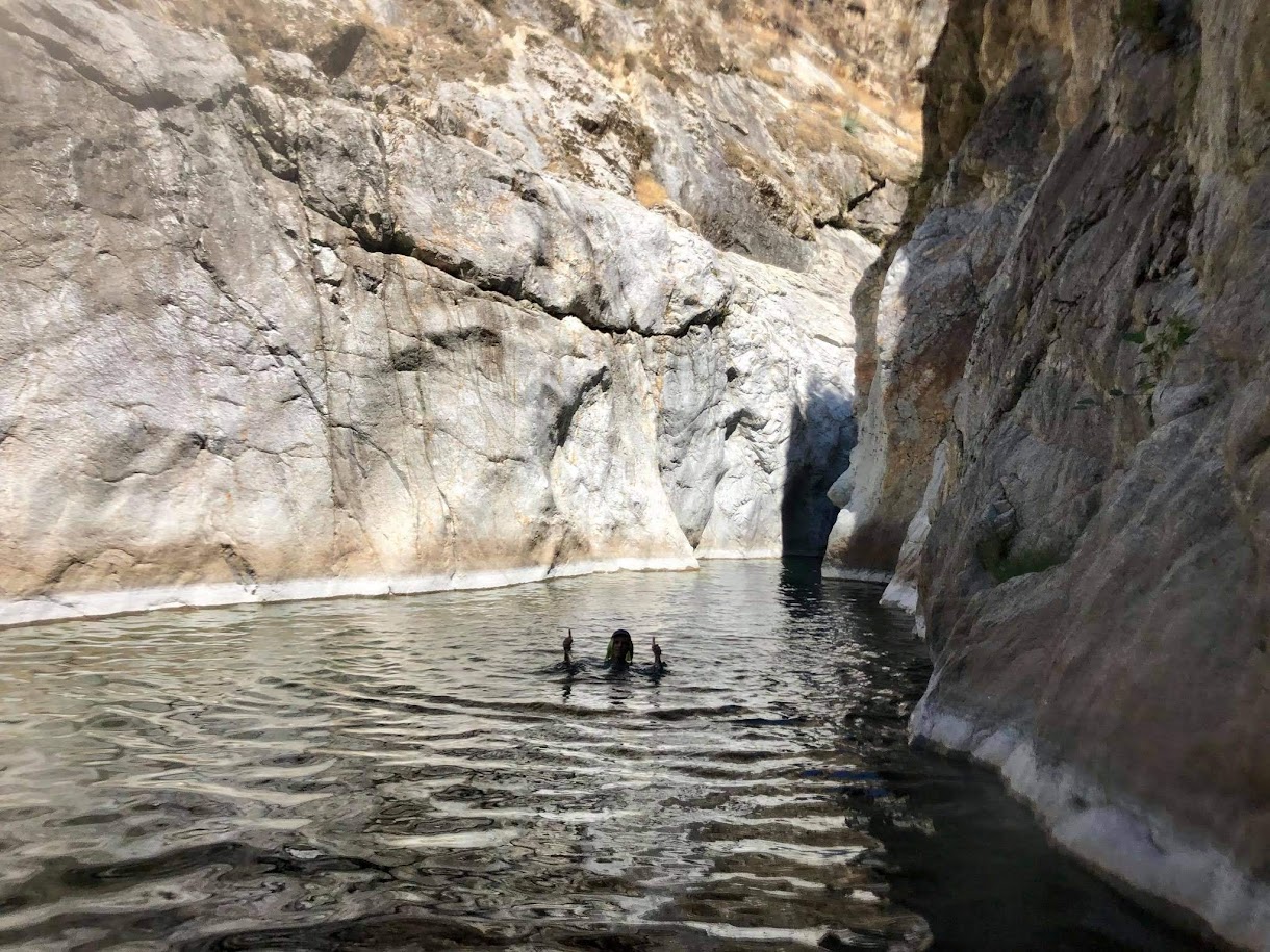
Downstream of the Yin Yang Pools the river returns to a more benign state with quiet pools separated by sections of rock hopping. Many the pools are now best crossed by wading or swimming. Eventually one reaches the top of the Narrows, which is arguably the most dramatic highlight feature of the Arroyo Seco River. Almost immediately, the river goes from a peaceful meander through the canyon to a narrow slot canyon. At the top of the narrows is a waterfall that guards entry in which even moderate flow would prove highly dangerous to the traveler on foot. It’s chilling to imagine the ferocity of the water when it reaches this constriction during periods of high flow. A small downclimb is required alongside the waterfall and a fixed rope may provide assistance. After the descent into the slot, one is required to swim through the remarkably long slot with vertical to even overhanging cliffs towering above. At the end of the slot, the river opens up into a huge pool with cavernous walls. The fun does not end here as the canyon stays tight for a considerable distance with numerous sculpted pools and passages between cliffs, all of which are stunning. Most people reach the Narrows from downstream and conclude their adventure at the waterfall. As such, expect to see an increasing amount of visitors from here to the conclusion of the route.


Eventually the Narrows section ends and the canyon walls open up. Soon the bridge crossing the river of the Marble Peak Trail is reached. One can cut the adventure here and return to the Indians Road as a 3 mile walk back to the parking or continue down the river for more highlights. While this last section is very accessible and does not have the wilderness character of the preceding part, it’s still deserving of inclusion in any “Complete” Arroyo Seco route with many spectacular cascades and pools (which require swimming) and the notable Keyhole feature, which is a smaller version of the Narrows but still dramatic and scenic in its own right. Similar to the Narrows, the river passes over a waterfall and descends through a slot (the “Keyhole”) before emerging into a large and deep pool that is famous for cliff jumping. Downstream of the Keyhole the pools and cascades continue. Near the bottom is the last feature worth mentioning: Rocky Creek Falls. This is a small falls just off the Arroyo Seco River. In high flow the falls is visible from the Indians Road a short distance from the Arroyo Seco Campground and Day Use Area, but approaching the base of the falls requires wading in the river. After a couple more wades downstream of Rocky Creek Falls the final stretch is a sand walk. One last crossing of the river at the picnic tables completes the river portion. Here it is evident that the rugged terrain of the preceding 14 miles of riverway are now over and the “Complete” Arroyo Seco is finished! Exit the river and head up the campground road to the upper parking lot to complete the loop.


The Complete Arroyo Seco also gives one the opportunity to experience the full breadth of human impacts on the canyon. Between Escondido Camp and the Narrows human impact is minimal with only a few items of trash encountered, likely carried by high river flows from much higher upstream. Solitude and wilderness character are strong. The setting and pools are pristine. Downstream of the Narrows more people will likely be encountered. However, those willing to make the trek to the Narrows seem to be cognizant of their impact and people are mostly respectful judging by the lack of trash. This begins to change downstream of the Marble Peak Trail bridge where the pools and gorges become much more accessible and closer to the parking area. Consequently, trash and noise pollution (boom boxes and parties) increases. The level of detritus becomes disheartening and reprehensible in the final 0.25 miles to the Day Use Area. The type of trash is wide ranging: bottles, coolers, broken inflatables, watermelons, cigarette butts, you name it! These users seem to have no respect for the environment which they came to enjoy. The good news is that if doing this route as a day hike, the party scene has long wrapped up by the time one reaches the Day Use Area, but it’s still sad to pass by so much trash even if the offending visitors have long left. I’d like to think that a more concerted education effort could help the situation in the lower gorge. More signs (both in Spanish and English) educating park visitors might help. Perhaps some more strategically placed trash bins would also help. I’d like to encourage each person who visits the Arroyo Seco to make a pledge to follow the Seven Principles of Leave No Trace. In particular, pack out all trash and be considerate of other visitors. The entire Arroyo Seco is a special place and it’s sad to see such disrespect for even a portion of it.
Edit 1/9/2018: Soon after publishing this post the Ventana Wilderness Alliance alerted me that they nominated the Arroyo Seco as a 2019 Leave Not Trace Hot Spot and it was accepted! A team of travelling trainers will be camped out to make visitor contacts, ideally for a week in this upcoming August. The VWA will be working on messaging and educational materials, and also collaborating on a clean-up while the trainers are here. Stay tuned to future announcements from the VWA on this extremely important project, which sounds like a fantastic plan to begin making significant headway on this problem!


Awesome country. I used to live nearby but now am in the Sierras. Regarding the trash situation, it’s a situation that happens everywhere and more and more. Governments don’t put the funding needed into maintaining our natural places, especially with increased visitation every year as our population grows. If we expect/depend on our government to fix the situation we will be waiting a long time. Novel as it sounds, WE can make signs, WE can pick up trash, while also writing letters to our local officials. I love seeing homemade signs made with love educating the public on what is needed to maintain these places they visit. Here in Truckee, CA we have huge issues with trash/broken sleds at roadside sledding hills. Some well made hand painted signs were made (by both local elementary children and their parents) encouraging people to pack out their trash and, combined with a dumpster strategically available during the winter, our local sled hill is no longer the disturbing monument to human indifference that it once was. If people have time and resources and frequently visit a particular locale, I would encourage them to 1) hike with trash bags 2) paint your own groovy well-made sign to help encourage leave no trace, and 3) be dogged in contacting your local officials whom you can work with to address situations.
Erik, I totally agree. Case in point: Soon after publishing this post the Ventana Wilderness Alliance alerted me that they nominated the Arroyo Seco as a 2019 Leave Not Trace Hot Spot and it was accepted! A team of travelling trainers will be camped out to make visitor contacts, ideally for a week in this upcoming August. The VWA will be working on messaging and educational materials, and also collaborating on a clean-up while the trainers are here. This sounds like a fantastic plan to begin making significant headway on this problem!
does anyone know how many miles it is, starting from Escondido campground all the way to the arroyo seco gorge, I did this hike the other day but ended up turning around once it started getting late
Awesome news Leor. Thanks for being an ambassador for mother nature!
cool post – I’ve done various positrons and excursions, like Santa Lucia Creek and Tassajara, but never the full sweep of Arroyo as depicted here. and yeah – its sad so many people are clueless about trash and impact. I agree with post above – more and more it really depends on those that use and love the land to encourage ‘leave no trace’
I found your excellent article after searching for more info on this trail prompted by the news of a trapped family that was rescued on the trail. Frankly, I’m still skeptical on how they could not find their way out of the gorge and had to request help and ultimately being airlifted from there. https://www.washingtonpost.com/lifestyle/2019/09/09/trapped-waterfall-this-man-sent-out-an-sos-message-bottle-someone-actually-found-it-downstream/
Curious – from where you hit the river from Escondito, how far downriver are the yin yang pools and narrows? We’ve made it to Eagle Creek Falls, but wondering how much longer of a trek it is to get to those two spots (is it doable as a dayhike?). Would it make more sense to hike upriver from Arroyo Seco campground to get to these two spots? Thanks for your help!
Hi there. Thanks for sharing about your adventure. I have been coming to Arroyo Seco for many years and have explored the Indians side and the area between the day use area and the narrows/waterfall. I am considering making the connection and am wondering how long you estimate it takes for a quick fit person to get from Indians to the horse bridge (Marble Peak Trail)? I would be doing this mid September so it should be quite low. I am assuming 1-2 days but I can’t tell from your writing. Thanks for any info you can provide!