
Pescadero Creek runs through a deep, shady canyon guarded by Butano Ridge, an aesthetic mountain that is over 15 miles long and rises over 2,200 feet. The snake-like shape of the ridgeline is unmistakable from Skyline Ridge and Long Ridge. The impressive relief in the area results in copious rainfall and an extremely lush environment where redwoods grow like weeds. The forests near Pescadero Creek are mature with some old growth, but the slopes of Butano Ridge have been logged more recently. Fortunately, the area is so conducive to growth that the redwoods have made a remarkably fast comeback. While some canyons have a dark, bland look characteristic of younger redwood forest, other parts are extremely pleasant. Aside from some stumps and lack of old growth, there is no longer any evidence of the logging operations and the Butano Ridge/Pescadero area looks like a carpet of green (as it should!). The north side of Pescadero Creek is also hilly with several redwood-filled canyons including Tarwater Creek and Towne Creek.

I have run the Butano Ridge Loop as well as the trails on the north side of Pescadero Creek, but never both together. Yesterday I put together both loops in a fantastic ~21 mile giant loop. I call this loop the pendulum, with Pescadero Creek the bottom, and the ridges on the north and south sides of the creek the top. I started at Tarwater Trailhead (~1,000 feet) taking the Upper Coyote Trail (brushy near the top) and then the Lower Coyote Trail down to near the Portola State Park visitor center. Pescadero Creek is crossed at around 350 feet, the first low point, followed by some ups and downs along the creek in Portola Redwoods State Park. A short run along Old Haul road leads to the Portola Trail entrance. Once on the Portola Trail, a long climb up to 2,000 feet along Butano Ridge begins. After some ridge running, the west end of the Butano Ridge loop drops all the way back to the bottom of the canyon where Pescadero Creek is crossed again at Shaw Flat (~300 ft), the second low point. The second climb is along the Brook Loop Trail up to Towne Ridge and the Sierra Club hikers hut at (~1,250 ft). From the hikers hut, a gorgeous stretch of ridge running leads to the Canyon Trail which switchbacks down into a canyon with lush redwood sorrel and old growth redwoods. The final 600 feet of elevation gain is along the Tarwater Loop passing by the rustic shed back to the Tarwater Trailhead.
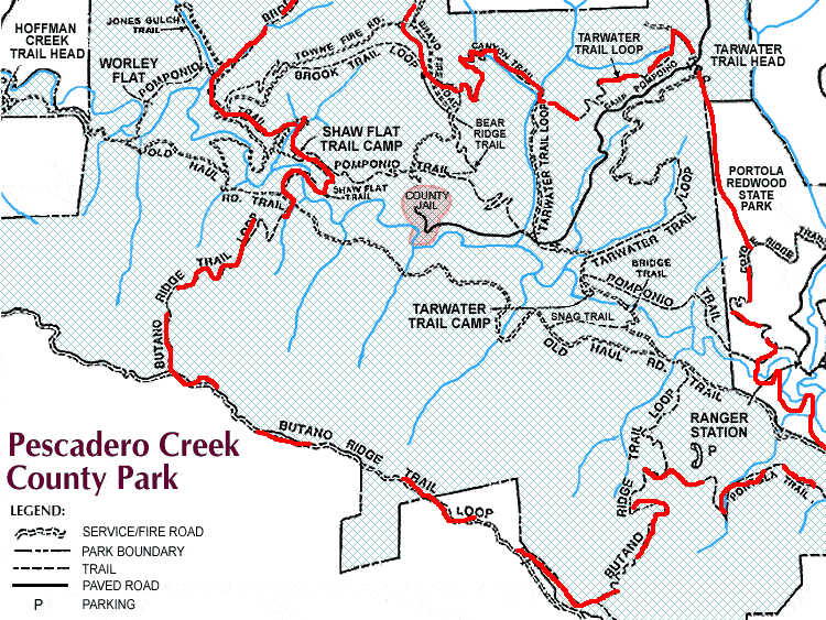
In all, there is around 4,000-4,500 feet of elevation gain on this loop and all but a couple miles are on awesome single track trails. Almost the entire distance is under forest canopy. There is a real feeling of wilderness and solitude in this area, which is remarkable considering its close proximity to the Bay Area population center. The 21 mile route took me 2:46. There are numerous potential extensions to this loop that could push the total length beyond 25 miles.
