
I had a great visit to Badger Pass at New Years so I was excited to return for a new objective – Ostrander Lake, Horse Ridge and Buena Vista Peak (see Glacier Point XC ski here and Dewey Point Snowshoe here). This is a fantastic route with stupendous views. The total mileage was 26.5 miles according to GPS (Strava route here, and first 4.2 miles here).


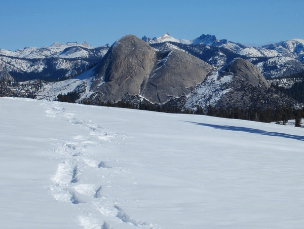
We stayed at Mariposa the night before and drove into the park with great anticipation as skies were clear and fresh snow coated the fir trees. We enjoyed a cup of coffee and breakfast snacks at the Badger Pass lodge before setting off down the Glacier Point Road at 8:30 a.m. I strapped on the microspikes for this four mile stretch which helped with traction while running. At the junction with the Bridalveil Creek trail, I switched to snowshoes and soon turned onto the Horizon Ridge trail. I was the first to travel this trail in several days, but the prior tracks were still easy to follow. While it was still only 10:00 a.m. the sun exposure on Horizon Ridge was already making it feel hot. Some sections of snow were getting thin, manifesting the warm nature of this ridge. As I ascended up Horizon Ridge proper, views of Yosemite opened up, including a fantastic and unique angle on Half Dome and Mount Starr King. I took photos from the top of Horizon Ridge and then descended to the junction of Bridalveil Creek trail (which I would descend). I continued up for 1.5 miles to the Ostrander Hut. I had passed a large group of skiers departing the hut and their turns in the powder were evident on the slopes above Ostrander Lake.


Continuing beyond Ostrander, the climbing became steeper on the final slopes approaching the summit of Horse Ridge. The breezes also began to pick up near the summit. Horse Ridge is a fascinating escarpment feature. It’s quite long and the ridge is a tale of two sides: the north side has a consistent cliff drop and steep open slopes below while the south side is gentle sloping with a forest of large trees. I enjoyed the panorama from Horse Ridge, including Half Dome, Tuolumne area peaks, the Clark Range, Buena Vista Crest, and even distant peaks like Mount Conness and Tower Peak. I gazed over at Buena Vista Peak as I checked my watch and figured I had enough time to at least attempt to reach Buena Vista so I set off down the south forested side of Horse Ridge. I soon found myself at a saddle between Horse Ridge and Buena Vista. It began to feel like true wilderness on this side of Horse Ridge since few people venture beyond Horse Ridge’s summit. I began climbing up the open slopes of Buena Vista with views opening up once again. The climbing was pretty straightforward until I reached the point where I had to access the northwest ridge of Buena Vista. Here the snow became step and icy for a small section and an ice axe would have been beneficial. A few steps later I was happy to be on the ridge snowshoing up the final part of the ridge to the summit. All in all, it took a little over an hour to go from Horse Ridge to Buena Vista Peak.


Buena Vista Peak is aptly named with a magnificent 360 degree view. The panorama also includes a impressive views of Gale Peak and Sing Peak on the southern border of the national park. In addition, there was a great vista of the high Sierra to the south including the evolution area of Mount Goddard and Mount Darwin. On the way down from Buena Vista, I went further down the northwest ridge before angling off which was an easier route and retraced my steps down to the saddle and then up to Horse Ridge, taking many photos along the way. On the way down from Horse Ridge, Half Dome was uniquely photogenic with a tongue of clouds surrounding its lower slopes. After some snacks at Ostrander Hut, I made my way down to the Bridalveil Creek trail. This route felt much longer than Horizon Ridge, partly because it is in fact 1.5 miles longer, and also because it’s quite monotonous meandering through the woods with not much to look at. I finally reached the Glacier Point Road and traded snowshoes for microspikes for the last 4.2 miles. I soon caught up to Erica and we traded photos before making the last push to the car. We both made it back to Badger Pass before dark with big smiles, extremely satisfied with the day’s adventure (Erica made it to Ostrander Hut for a 19.5 mile snowshoe).


Wow, just reading this got me tired––tried to make it up to Ostrander this weekend, but due to a late start and my lack of skill on tele-skis, mixed with a lot of ice and . . . a 25 lb pack . . . I got close and happy enough . . . they need some snow up there.
I figured snow conditions might not be ideal after a week of sunshine and warm temps. Glad you enjoyed the outing!
Nice! We must’ve passed each other… we were on our way out when you were on your way in. We stayed at Ostrander for 2 nights. You have some nice pics of our groups tracks… here’s my buddy pace ready to ski down from Buena Vista Peak… http://telek.smugmug.com/Backcountry-Skiing/2012-winter-2013-spring/Ostrander-Hut-Feb-8-2013/i-NppzMfc/0/XL/IMG_1696-XL.jpg we had a 2 min window before we were enveloped in fog again.
Awesome you found this post! That was a nice line off Buena Vista and lots of great lines below Horse Ridge. It looks like your group had a lot of fun!