
Big Sur/Ventana Wilderness Adventure Running Map HERE.
Annotated Photos: Check out the complete set of Annotated Panoramas on Flickr. All Photos and annotations by Leor Pantilat.


Annotation Key:
- View from unnamed dome in Tuolumne Meadows, Yosemite NP
- Cathedral Range View from High Sierra Camps Loop, Yosemite NP
- Glaicer Point View winter & summer comparison, Yosemite NP
- Stone Ridge Direct, Cone Peak, Ventana Wilderness
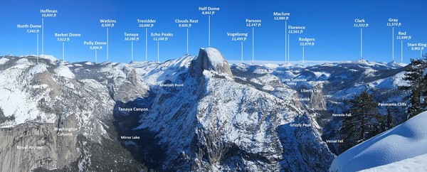
- Winter view from Glacier Point, Yosemite NP
- Winter view from Dewey Point, Yosemite NP
- Wide panorama from Winter Alta, Sequoia NP
- Route up Winter Alta, Sequoia NP
- Great Western Divide from Mount Silliman, Sequoia NP
- Palisades from Mount Silliman, Sequoia NP
- Palisades from Mount McDuffie, Kings Canyon NP
- Northern Yosemite from Volunteer Peak, Yosemite NP
- Eldorado Ice Cap from Austera Peak, North Cascades NP
- View from Primus Peak, North Cascades NP
- Yosemite High Country from Mount Dana, Yosemite NP
- Ritter Range and Cathedral Range from Kuna Peak, Yosemite NP
- LeConte Divide and Red Mountain Basin from Red Mountain, John Muir Wilderness
- The Great Western Divide & Tablelands from Winter Alta, Sequoia NP
- The Great Western Divide from Winter Alta, Sequoia NP
- Southern Pickets from Luna Peak, North Cascades NP
- Southern Pickets, North Cascades NP
- View from Mount Williamson, Sequoia NP
- Northern Palisades from Dusy Basin, Kings Canyon NP
- Dusy Basin, Kings Canyon NP
- Northern Palisades from Palisade Glacier, John Muir Wilderness
- The Kaweah Range from Milestone Mountain, Sequoia NP
- The Picket Range from West McMillan Spire, North Cascades NP
- Northern Pickets from East Fury, North Cascades NP
- The Great Western Divide from Moose Lake, Sequoia NP
- Tuolumne Meadows and vicinity from Mount Dana, Yosemite NP
- Alpine lakes from Banner Peak, Ansel Adams Wilderness
- View from Parsons Peak, Yosemite NP
- Desolation Six Summits, Desolation Wilderness
- Desolation Route, Desolation Wilderness
- Ptarmigan Traverse Route to LeConte Glacier, Glacier Peak Wilderness
- Ptarmigan Traverse Route from Spider-Formidable Col, Glacier Peak Wilderness
- Ptarmigan Traverse Route to Spire Col, Glacier Peak Wilderness
- Middle Palisade Route, John Muir Wilderness
Washington:
High Sierra:
A list of notable mountains I have climbed in WA and CA (no particular order and needs updating):
Notable Peaks in Washington State:
- Mount Rainier (3)
- Mount Adams
- Mount Baker
- Glacier Peak
- Mount Stuart
- Mount Shuksan (2)
- Goode Mountain
- Mount Logan (2)
- Mount Buckner
- Mount Maude
- Mount Fernow
- Seven Fingered Jack
- Fortress Mountain
- Chiwawa Mountain
- Clark Mountain
- Eldorado Peak (4)
- Dorado Needle
- Forbidden Peak (2)
- Sahale Mountain (3)
- Klawatti Peak
- Austera Peak
- Mount Redoubt
- Mount Challenger
- Mount Fury
- Luna Peak
- West McMillan Spire
- Snowfield Peak (2)
- Snowking Mountain
- Mount Formidable
- Sentinel Peak
- Dome Peak
- Colhuck Peak
- Mount Olympus (2)
- Sloan Peak
- Del Campo Peak
- Silver Star Mountain
- Lemah Mountain
- Ruth Mountain
- Whatcom Peak
- Crater Peak
- Ruby Mountain
- Mount Daniel
- Keyes Peak
- Three Fingers
- Mount Pugh
- Hibox Mountain
- South Brother (Olympics)
- Kaleetan Peak
- Primus Peak
Notable Peaks in California:
- Mount Williamson
- Black Kaweah
- Mount Sill (2)
- Middle Palisade
- Clyde Minaret
- Mount Darwin
- Mount Mendel
- Mount Goddard
- Bear Creek Spire (2)
- Mount Gabb
- Mount Abbott
- Mount Haeckel
- Mount Wallace
- Points John, Wesley & Powell
- Picture Peak
- Royce Peak
- Merriam Peak
- Feather Peak
- Mount Banner
- Mount Ritter
- Mount Lyell (2)
- Mount Maclure (2)
- Mount Conness (2)
- North Peak
- Matterhorn Peak
- Sawtooth Peak
- Thompson Peak (Trinity Alps)
- Half Dome
- Clouds Rest
- Mount Shasta
- Mount Dade
- Whaleback
- Milestone Mountain
- Midway Mountain
- Alta Peak
- Winter Alta
- Mount Dana
- Mount Vogelsang
- Volunteer Peak
- Mount McDuffie
- Crown Point
- Mount Agassiz
- Columbine Peak

Hey. Great pictures from you Snofield peak climb back in 2005. I was actually up there in august of 2005 and took many of the same pictures. I was wondering if you knew anything about the old path/trail up Colonial Creek starting at the highway? I was heard that there was a path there back in the 60’s and when we were camping we saw a few guys camping near the base of colonial peak. If you know anything about this or know anyone who might, i would really appriciate it. Also, have you ever doe the isolation traverse which is apparently from snowfield peak to eldorado….any info on either of these inquiries would be much appriciated. Thanks and have a great climbing season!
Micah
have you ever ran up Mt. Shasta?
i was looking down your list and couldn’t see it. By the way-good job for stinson beach. you ran roundtrip from the top to bottom and back?
Also have you done the dipsea run?
when i was 14 not long ago i completed the run in 58/59 minutes!!
i love your site. very cool.
Quinn