
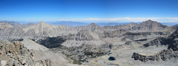
Mount Stanford is a very attractive mountain located on the Kings-Kern Divide straddling Kings Canyon and Sequoia National Parks. At 13,973 ft, it’s just shy of fourteen thousand feet so it doesn’t draw the attention comparable to Sierra fourteeners, but it’s just as impressive of a mountain in terms of stature, difficulty to surmount, and commanding views. The peak is extremely remote with long approaches via either the eastside utilizing Kearsarge Pass or University Pass or the westside from Road’s End in Kings Canyon. In fact, the westside of the peak harbors one of the most remote drainages in the High Sierra with rarely seen views of the Ericsson Crags and the west face of Stanford. As far as trail visibility, Mount Stanford is only prominent from a small stretch of the John Muir Trail from Forester Pass down to Center Basin. Via the southwest slopes originating in Upper Kern Basin, most of the elevation gain to climb Mount Stanford is fairly easy, but the summit itself is located along a narrow and precipitous ridgeline to the north of Gregory’s Monument. Strava route here.


Gregory’s marks the end of the easy scrambling and while it’s only 30 feet lower in altitude than Mount Stanford, Gregory’s is more like a point along the ridge instead of a true summit. The scramble between Gregory’s Monument and Stanford features an improbable ledge/ramp that allows Stanford to be climbed without technical gear from Gregory’s Monument (otherwise the cliffs are sheer). However, care must be taken due to immense exposure and some loose rock along the traverse and scramble. For my summit of Stanford, I decided to approach via Road’s End and make a loop including East Lake, Harrison Pass, Upper Kern Basin, Milly’s Foot Pass and gorgeous Lake Reflection. While my route entailed more miles and elevation gain to climb Stanford than the eastside approaches (or even if I chose to do it as an out-and-back), I’m certain it was the more aesthetic and scenic route.

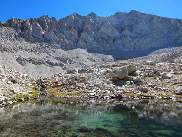
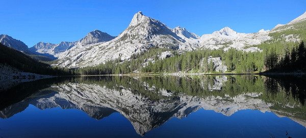
Along the way to Stanford I walked beneath the towering spires of the Ericsson Crags and passed by several high elevation tarns. Travel up the drainage to Harrison Pass was better than I expected and I managed to skirt most of the scary sketchy loose gravel on the steep slope heading up the final chute to Harrison Pass. Above Harrison Pass, I started to feel the altitude a bit having come directly from sea level and the cumulative effects of exertion to reach this point. It took a few minutes to negotiate the scramble portion and figure out the route, but I was soon atop Stanford enjoying the stunning panoramic views including the Kaweah Range, the Great Western Divide, Mount Brewer and the Sierra Crest. After departing Stanford, I headed down into Kern Basin and traversed around the shoulder of Mount Ericsson’s south ridge heading for Milly’s Foot Pass. I had been to Milly’s in 2009 and it was just as sketchy as I remembered it with kitty litter over the rock. I felt more safe climbing more difficult but solid rock on the side of the chute than descending down the chute itself. Fortunatley, this portion is only 100 feet or so and I was soon on gravel and talus slopes heading down toward breathtaking Lake Reflection, one of the finest alpine lakes in all of the Sierra. This heavenly lake features crystal clear waters and dramatic views of Mount Genevra and Mount Jordan, seemingly rising straight up from the pristine shores. I enjoyed a snack and rest at Lake Reflection and then continued back to East Lake, completing the lollipop loop of the Kings-Kern Divide. I met up with Erica just below East Lake and we enjoyed stellar evening light on Mount Bago as we descended toward Junction Meadow. The final 10 miles of trail back to Road’s End were enjoyable with net downhill and beautiful evening light. Next time I hope to climb Mount Ericsson and Mount Genevra. Overall, the route entailed nearly 38 miles and 11,000 feet of elevation gain. Strava route here.


inspiring and awesome, thanks for sharing
財布 アクセサリー マリメッコバッグ http://fushanwao.casiojpdonimpact.org/
Leor,
You are like a modern day Galen Rowell as an adventure photographer. What camera(s) lenses do you use?