
Recently I have been trying the new Clif Organic Energy Food on adventures and I really like the stuff for quick but quality calories on the go and they will definitely be a part of my nutrition plan on adventures this summer where REAL food is a necessity. Pizza Margarita and Sweet Potato Sea Salt are the salty flavors while Banana Beet and Banana Mango taste like delicious smoothies. I’m hosting a giveaway and the winner will get two samples of each flavor (eight total). Just post a comment and a random winner will be drawn sometime next week. Good luck!
The South Coast of Big Sur has some of the best scenery of the entire Big Sur coast. The majority of the region is protected by the Silver Peak Wilderness, a 31,555 acre wilderness established in 1992. While only a fraction of the size of the better known Ventana Wilderness to the north, there are several awesome trails and great opportunities for exploration in the Silver Peak Wilderness. The region has great biodiversity of vegetation including redwoods, chaparral, oak woodland, pine forest, and even some groves of the rare Santa Lucia Fir. This post contains photos from several destinations in the wilderness, including: (1) Pt. 2,866 or “Soda Peak“; (2) the wilderness’s namesake summit, 3,520 ft Silver Peak; and (3) Cinnamon Falls along Alder Creek. 

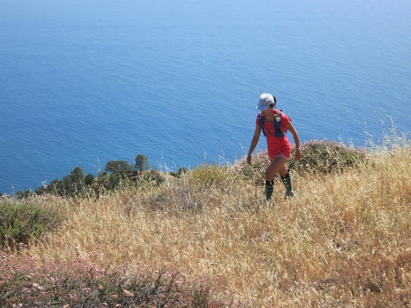
 Our first destination was Pt. 2,866, a vista I had seen last fall and was eager to see again. This point has no official name but “Soda Peak” makes geographical sense since it sits at the head of the Soda Creek drainage. Soda Peak is on the WSW ridge coming off Silver Peak. The ridge contains several high points but the last one and most dramatic is Point 2866. Since Soda Peak is the last point of prominence along the ridge it has a commanding view of the south Big Sur coast. The rocky limestone summit is also mostly free of brush enabling an excellent 360 degree panorama including San Martin Top, Silver Peak, Cone Peak and Mount Mars. The easiest way to reach Soda Peak is via the Soda Creek Trailhead and then the Buckeye Trail. At about 2,100 ft along the Buckeye Trail take a use trail that starts near a bent lone pine tree on the southern of two spur ridges coming off Soda Peak. The use path is fairly easy to follow and in about 750 vertical feet you’re on top and gazing across the Soda Creek drainage to Mount Mars and beyond, a truly spectacular vantage. It’s only about 3 miles each way to Soda Peak, but the few miles pack around 2,500 ft of elevation gain.

 I have been around Silver Peak many times but never summited until now. The Cruickshank Trail is beautiful as it traverses the hillside above Villa Canyon passing through numerous different plant and forest communities. It’s a nice trek from the Villa-Salmon Saddle to the peak passing through young forests of Sargeant’s Cypress and Coulter Pine with excellent views in both directions. Silver Peak contains an entertaining summit register placed by Boon Hughey who has accounted for many of the summit entries over the years. Erica and I were the 14th and 15th visitors this year so there is not too much traffic to this fairly remote summit. We enjoyed a unique view as a 2,500 ft marine layer filled the canyons and crested over Mount Mars and County Line Ridge into a fog bank cascade. Silver Peak also has a very nice view to Cone Peak.

 After enjoying the descent down Villa Canyon with its rugged reddish canyon rocks, I took the Buckeye Trail and then went off trail to check out a falls I had identified on the topographic map and satellite. It turns out this multi-step falls is one of the tallest on a main stem creek in the entire Big Sur region. The falls includes two main segments and a couple smaller ones totaling over 150 ft (a conservative estimate based on my watch altimeter). The rocks surrounding the falls are reddish brown, hence I have called the falls “Cinnamon Falls.” The descent down to the base of the falls was precarious on loose rock and very steep hardpan but I enjoyed the lowest two pools and imagined how tremendous this falls would be in high flow after winter rains. I will definitely put Cinnamon Falls on my calendar for next winter. With a strong El Nino developing for winter 2015-2016 there are some decent odds that this falls and other waterfalls in Big Sur will have some big flows next winter. Upon exiting the base of the falls, I found a better route which was still steep but had some oak trees to hang on to and reasonably solid rock to climb. This will be my route into the base of Cinnamon Falls in the future. Perhaps the best view of Cinnamon Falls is along the spine of this rocky sub-ridge where you can get a good overview of the falls and see most of it at once. From the bottom it is impossible to see the entire falls.


I’m overcoming my natural introversion to comment because I want to win the energy food! I’m an avid follower of this blog, which adds several additional dimensions to my sense of what’s possible. (You and I embark from many of the same trailheads, but from there I proceed much more timidly and slowly.) And I’m full of admiration not only of this spring’s tally of undocumented waterfalls, but also of your taste and discernment when it comes to naming them. Keep on keeping on!
Thanks for doing the giveaway Leor; come back to the North Cascades sometime!
I had three of the new Clif foods while pacing 38 miles at Westerns States this weekend, with terrific results!
I’m going to use them a lot next week for some running adventures in the Sierras, including the Rae Lakes loop!
Thanks for the dose of inspiration and continued discoveries!
your blog is a major inspiration and it’s got me dreaming of the west coast! some day soon, hopefully… thanks for the blog and the clif giveaway.
from Virginia… Tim